METAR & TAF KRHI
Current METAR
Observed 19:53Z
KRHI 271953Z AUTO 30006KT 10SM SCT033 31/21 A2970 RMK AO2 SLP046 T03060211
- Wind
- 300° @ 6 kt
- Visibility
- 10 SM
- Temp / Dew
- 31°C / 21°C
- Altimeter
- 29.70 inHg
- Clouds
- SCT
- Density alt
- 4,206 ft
- Ceiling
- Unlimited
- Rules
- VFR
Airport info & contacts
Manager on record, flight service, ARTCC, attendance schedule and pattern altitude — published by the FAA and refreshed every 28 days.
Location
- From city
- 2 NM SW
- VFR sectional
- GREEN BAY
- ARTCC
- ZMP · MINNEAPOLIS
- NOTAM facility
- RHI (NOTAM-D)
Airport manager
- Name
- MATTHEW LEITNER
- Phone
- 715-365-3418
- Address
- 3375 AIRPORT RD, RHINELANDER WI 54501
Flight service · Hours
- FSS GRB
- GREEN BAY1-800-WX-BRIEF
- Attendance
- 0600-1900
Frequencies
Tap any row to copy the frequency to your clipboard.
Runways & pattern
Full pagePattern entry · RWY 33
LEFT TRAFFIC| Runway | Heading (°M) | Length | Surface | Traffic |
|---|---|---|---|---|
| 09/27 | 85° / 265° | 6,800 ft | CONC | Standard L |
| 15/33Favored | 144° / 324° | 5,201 ft | ASPH | Standard L |
Runway end performance
| End | TORA | TODA | ASDA | LDA | VGSI | Approach lights | Obstruction |
|---|---|---|---|---|---|---|---|
| 09 | 6,799' | 6,799' | 6,799' | 6,799' | PAPI 4-box left(3°) | MALSR | — |
| 27 | 6,799' | 6,799' | 6,799' | 6,799' | PAPI 4-box left(3°) | — | — |
| 15 | 5,201' | 5,201' | 5,201' | 5,201' | VASI 4-box left(3.75°) | — | 75', tree, 1740' from thr, 200' R of cntrln, slope 20 |
| 33 | 5,201' | 5,201' | 5,201' | 5,201' | PAPI 4-box left(3°) | — | 30', tree, 1145' from thr, 160' R of cntrln, slope 31 |
Declared distances in feet. TORA = takeoff run available, TODA = takeoff distance, ASDA = accelerate-stop, LDA = landing distance.
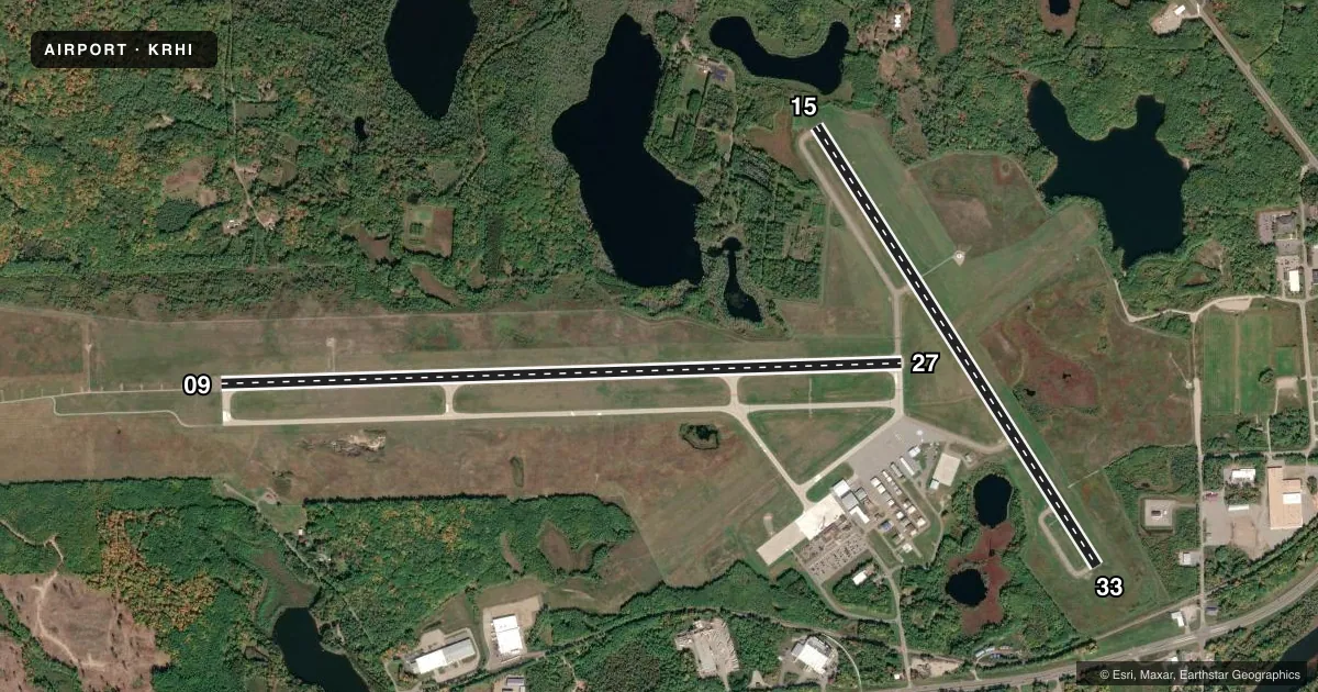
Airport sketch
Runways drawn to scale from FAA survey coordinates, rendered over satellite imagery. Not for navigation.
Approaches & charts
ILS · 1
Services on the field
Fuel grades, oxygen, maintenance, ramp storage and lighting — as declared to the FAA by the airport operator.
Fuel & services
- Fuel
- 100LLA
- Oxygen (bottled)
- Not available
- Oxygen (bulk)
- Not available
- Airframe repair
- Major
- Power plant repair
- Major
- Other services
- AFRT,AMB,CHTR,INSTR,RNTL,SALES
Ramp & ground
- Transient storage
- Tie-down
- Hangar
- Landing fee
- No fee published
- Customs
- Not available
- Lighting schedule
- SEE RMK
- Beacon schedule
- SS-SR
- Beacon
- White / Green (civil land)(WG)
- Wind indicator
- Lighted
- Segmented circle
- No
Fuel & FBOs
Cheapest 100LL and Jet A on the field and nearby. Always confirm with the FBO before taxi.
Airport notes
Surface conditions, obstructions, local procedures, lighting outages and other notes published with each FAA cycle.
General notes
- BIRDS & COYOTE ON & INVOF ARPT.
- FOR CD IF UNA TO CTC ON FSS FREQ, CTC MINNEAPOLIS ARTCC AT 651-463-5588.
- SFC CONDS NOT MONTRD BTWN 0000 - 0500 HRS.
Lighting notes
- HIRL RWY 9/27 PRESET LOW INTST; TO INCR INTST & ACTVT MALSR RWY 09; REIL RWY 15, 27 & 33; PAPI RWY 09 & 27; HIRL RWY 09/27 & 15/33 - CTAF. VASI RWY 15 & PAPI RWY 33 OPR CONSLY.
Fuel notes
- 100LLSELF SVC FUEL ABVL H24.
- ASELF SVC FUEL ABVL H24.
Runway surface & condition
- 09/27PCR VALUE: 390/R/B/W/T
- 15/33PCR VALUE: 380/F/B/X/T
Other notes
- PPR FOR UNSKED ACR OPNS WITH MORE THAN 9 PSGR SEATS CALL AMGR 715-550-3419 OR 715-550-3417.
VFR map & nearby airports
VFR sectional. Tap any ICAO chip to open that airport.
Key facts · KRHI
Answer card- ICAO
- KRHI
- Name
- RHINELANDER/ONEIDA COUNTY
- Location
- RHINELANDER, WISCONSIN
- Elevation
- 1,623.3 ft MSL
- Traffic pattern altitude
- 2,623.3 ft MSL (1,000 AGL)
- Control tower
- Non-towered (use CTAF)
- Total runways
- 2
- Longest runway
- 09/27 · 6,800 ft
- Published ILS approaches
- 1
- Published frequencies
- 2
- Magnetic variation
- 3°
- Current flight rules
- VFR
- Current wind
- 300° at 6 kt
- Favored runway now
- RWY 33
Rhinelander/Oneida County Airport sits in Rhinelander, Wisconsin. Field elevation is 1,623.3 ft MSL. The airport has two runways. The longest is runway 09/27 at 6,800 ft. Runway 15/33 is 5,201 ft. There is no control tower, so expect CTAF and UNICOM self-announce traffic on 123.0.
The field has one ILS approach. It serves runway 09. Pattern altitude is not published, so use the standard 1,000 ft AGL for light piston traffic unless current airport information says otherwise. Rhinelander Flying Service is on the field. It carries 100LL, Jet A and Jet A Prist. Self-serve fuel is available 24 hours a day for both 100LL and Jet A.
A few operational notes matter here. Birds and coyotes are reported on and near the airport. Surface conditions are not monitored between 0000 and 0500 hours. Runway lighting is CTAF-controlled on both runways. Runway 09 also has medium-intensity approach lighting with runway alignment indicator lights. If you are bringing in an unscheduled aircraft with more than 9 passenger seats, prior permission is required. For clearance delivery when Flight Service is not available, Minneapolis ARTCC is listed as the contact. Check the current FAA Chart Supplement before departure for any updates.