METAR & TAF KRAP
Current METAR
Observed 12:52Z
KRAP 271252Z 00000KT 10SM CLR 27/14 A2993 RMK AO2 SLP096 T02720139
- Wind
- 000° @ 0 kt
- Visibility
- 10 SM
- Temp / Dew
- 27°C / 14°C
- Altimeter
- 29.93 inHg
- Clouds
- CLR
- Density alt
- 5,400 ft
- Ceiling
- Unlimited
- Rules
- VFR
Airport info & contacts
Manager on record, flight service, ARTCC, attendance schedule and pattern altitude — published by the FAA and refreshed every 28 days.
Location
- From city
- 8 NM SE
- VFR sectional
- CHEYENNE
- ARTCC
- ZDV · DENVER
- NOTAM facility
- RAP (NOTAM-D)
Airport manager
- Name
- PATRICK DAME
- Phone
- 605-394-4195
- Address
- 4550 TERMINAL RD - STE 102, RAPID CITY SD 57703
Flight service · Hours
- FSS HON
- HURON1-800-WX-BRIEF
- Attendance
- ALL
Frequencies
Tap any row to copy the frequency to your clipboard.
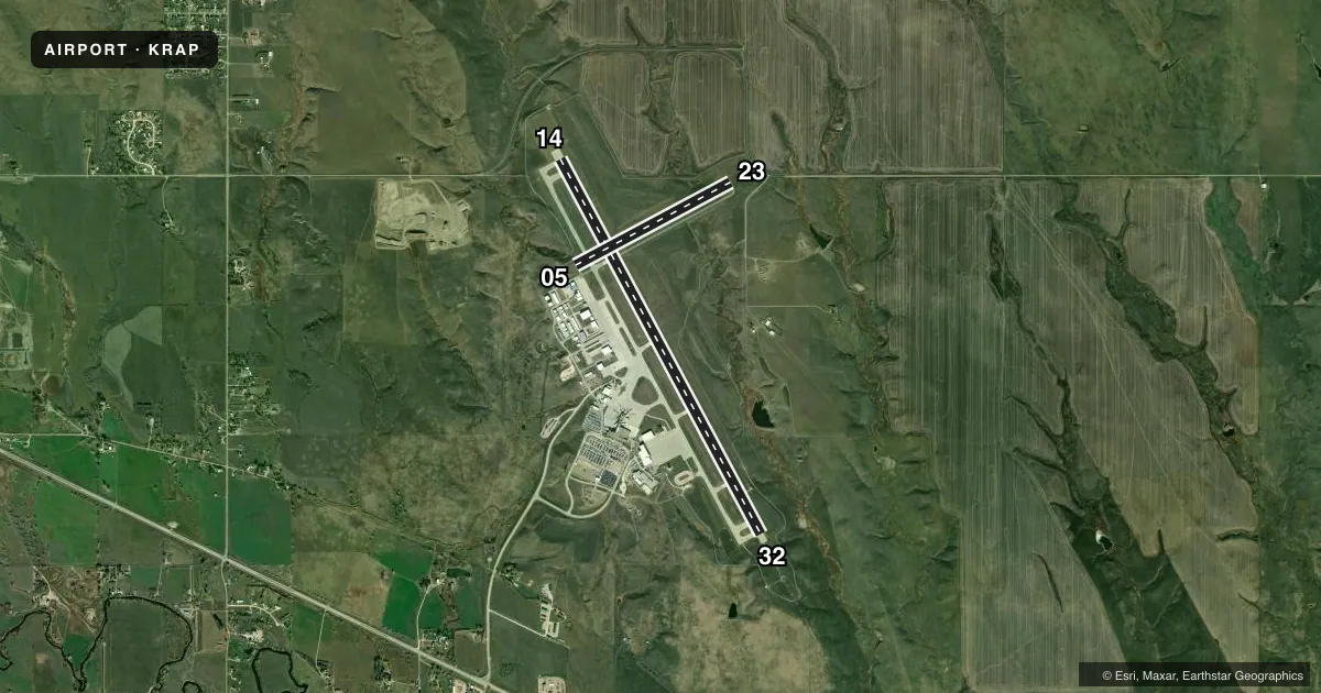
Runways & pattern
Full pagePattern entry · RWY 14
LEFT TRAFFIC| Runway | Heading (°M) | Length | Surface | Traffic |
|---|---|---|---|---|
| 14/32 | 144° / 324° | 8,701 ft | CONC | Standard L |
| 05/23 | 54° / 234° | 3,601 ft | ASPH | 05 R |
Runway end performance
| End | TORA | TODA | ASDA | LDA | VGSI | Approach lights | Obstruction |
|---|---|---|---|---|---|---|---|
| 14 | 8,701' | 8,701' | 8,701' | 8,701' | PAPI 4-box left(3°) | — | 25', fence, 1000' from thr, 435' R of cntrln, slope 32 |
| 32 | 8,701' | 8,701' | 8,701' | 8,701' | PAPI 4-box left(3°) | MALSR | — |
| 05 | 3,601' | 3,601' | 3,601' | 3,601' | PAPI 2-box left(3°) | — | — |
| 23 | 3,601' | 3,601' | 3,601' | 3,601' | PAPI 2-box left(3°) | — | 15', road, 628' from thr, 0' R of cntrln, slope 28 |
Declared distances in feet. TORA = takeoff run available, TODA = takeoff distance, ASDA = accelerate-stop, LDA = landing distance.
Airport sketch
Runways drawn to scale from FAA survey coordinates, rendered over satellite imagery. Not for navigation.
Approaches & charts
ILS · 1
Services on the field
Fuel grades, oxygen, maintenance, ramp storage and lighting — as declared to the FAA by the airport operator.
Fuel & services
- Fuel
- 100LLA
- Oxygen (bottled)
- High pressure
- Oxygen (bulk)
- Not available
- Airframe repair
- Major
- Power plant repair
- Major
- Other services
- AFRT,AMB,AVNCS,CHTR,INSTR,RNTL,SALES,SURV
Ramp & ground
- Transient storage
- Tie-down
- Hangar
- Landing fee
- Yes
- Customs
- Not available
- Lighting schedule
- SEE RMK
- Beacon schedule
- SS-SR
- Beacon
- White / Green (civil land)(WG)
- Wind indicator
- Lighted
- Segmented circle
- Yes
Fuel & FBOs
Cheapest 100LL and Jet A on the field and nearby. Always confirm with the FBO before taxi.
Airport notes
Surface conditions, obstructions, local procedures, lighting outages and other notes published with each FAA cycle.
General notes
- BIRDS ON & INVOF ARPT.
- BE ALERT: EXTENSIVE MILITARY JET TFC INVOF & NNW OF ARPT.
- LINE-OF-SIGHT IS RESTRICTED BETWEEN RY 14 & RY 23 PHYSICAL ENDS.
- 152 FT AGL TWR 2.5 NM NNW OF ARPT.
- BE ALERT DO NOT MISTAKE ELLSWORTH AFB, LOCATED 6.5 NM NNW FOR RAPID CITY RGNL.
- TWR HAS LIMITED VISIBILITY OF TWY T1 AND TWY T2 AND TWY B AT AER RWY 23
- USE OF ARMY NATIONAL GUARD (ANG) RAMP IS OFFICIAL BUSINESS ONLY; FOR PPR CALL ANG FLIGHT OPS AT (605) 737-6128. NORMAL ANG OPS ARE TUES-FRI 1400-0030Z++ EXCEPT HOLIDAYS.
- OVERNIGHT PARKING ALLOWED IN DESIGNATED TIEDOWN AREAS ONLY.
- CTC GROUND FOR FREE TIE-DOWN LOCATIONS, OR CALL ARPT OPNS AT 605-593-3419.
- ALL CHARTER SERVICED ACFT OVER 12,500 LBS MUST CTC ARPT OPNS AT 605-593-3419 AT LEAST 48 HOURS PRIOR TO ARRIVAL.
- DIVERTING NON-BASED AIR CARRIERS CTC ARPT OPS AT (605) 593-3419 PRIOR TO DIVERTING DUE TO LIMITED GATE SPACE. NO CUSTOMS SERVICE AVBL.
- FOR CD IF UNA ON FREQ, CTC ATCT AT 605-646-6921. WHEN ATCT CLSD, CTC ELLSWORTH APCH AT 605-385-6198. WHEN APCH CLSD, CTC DENVER ARTCC AT 303-651-4257.
- RWY 5/23 NOT AVBL TO ACFT OVER 12500 LBS TO TAXI.
- HIGH VOL OF HELI TOURS INVOF MT RUSHMORE AND CRAZY HORSE MONUMENTS AT OR BLW 7500 FT; ALL OTR ACFT SHOULD RMN AT OR ABOVE 7700 FT AND MAINTAIN 1 NM HORIZONTAL SEPARATION FROM THE MONUMENTS; PILOTS ARE ADVISED TO MONITOR 122.85 FOR TFC ADVISORIES.
Lighting notes
- WHEN ATCT CLSD ACTVT MALSR RWY 32; REIL RWY 14; HIRL RWY 14/32; MIRL RWY 05/23; TWY A & B LGTS - CTAF. PAPI RWYS 05, 14, 23, 32 OPR CONSLY.
Fuel notes
- A100LL & JETA SELF SVC AVBL 24 HRS WITH CREDIT CARD ONLY NE SIDE OF GA RAMP.
Runway surface & condition
- 05/23PCR VALUE: 80/F/C/X/T
- 14/32PCR VALUE: 635/R/D/W/T
- 05/23RWY 05/23 NOT AVBL FOR PART 121/PART 380 OPS WITH SKED PAX CARRYING OPS MORE THAN 9 PAX SEATS AND NON-SKED PAX CARRYING OPS MORE THAN 30 PAX SEATS.
Other notes
- ARFF INDEX C AVBL UPON REQ.
- LNDG FEES RQRD FOR AIRCRAFT 12,500 LBS OR GTR.
VFR map & nearby airports
VFR sectional. Tap any ICAO chip to open that airport.
Key facts · KRAP
Answer card- ICAO
- KRAP
- Name
- RAPID CITY RGNL
- Location
- RAPID CITY, SOUTH DAKOTA
- Elevation
- 3,203.5 ft MSL
- Traffic pattern altitude
- 4,203.5 ft MSL (1,000 AGL)
- Control tower
- Towered · 0600-2200
- Total runways
- 2
- Longest runway
- 14/32 · 8,701 ft
- Published ILS approaches
- 1
- Published frequencies
- 11
- Magnetic variation
- 8°
- Current flight rules
- VFR
- Current wind
- 000° at 0 kt
- Favored runway now
- –
Rapid City Rgnl sits in Rapid City, South Dakota. Field elevation is 3,203.5 ft MSL. The airport has two runways. The longest is 14/32 at 8,701 ft. Runway 05/23 is 3,601 ft. The tower is open 0600-2200. One ILS is published for runway 32. Pattern altitude is not published in the facts, so use the standard 1,000 ft AGL for light piston unless the current FAA Chart Supplement says otherwise.
This is a busy field with a lot of helicopter tour traffic near Mount Rushmore and Crazy Horse. The published guidance says other aircraft should stay at or above 7,700 ft. Keep 1 NM horizontal separation from the monuments. Birds are also reported on and near the airport, so keep a sharp scan on arrival and departure. The tower has limited visibility of taxiway T1, taxiway T2 and taxiway B near the approach end of runway 23.
On the field, Rapid Fuel and Westjet Air Center both carry 100LL and Jet A. Contact ground control for free tie-down locations or call airport operations if you need the current setup. If you are operating a chartered aircraft over 12,500 lb, call airport operations at least 48 hours before arrival. When the tower is closed, use the published lighting procedures and contact the listed approach or ARTCC numbers in the current Chart Supplement for clearances.