METAR & TAF KPVD
Current METAR
Observed 12:51Z
KPVD 271251Z 00000KT 10SM SCT100 BKN250 19/10 A2986 RMK AO2 SLP112 T01890100 $
- Wind
- 000° @ 0 kt
- Visibility
- 10 SM
- Temp / Dew
- 19°C / 10°C
- Altimeter
- 29.86 inHg
- Clouds
- BKN
- Density alt
- 621 ft
- Ceiling
- 25,000 ft AGL
- Rules
- VFR
Airport info & contacts
Manager on record, flight service, ARTCC, attendance schedule and pattern altitude — published by the FAA and refreshed every 28 days.
Location
- From city
- 6 NM S
- VFR sectional
- NEW YORK
- ARTCC
- ZBW · BOSTON
- NOTAM facility
- PVD (NOTAM-D)
Airport manager
- Name
- IFTIKHAR AHMAD
- Phone
- 401-691-2000
- Address
- RI AIRPORT CORP, 2000 POST RD, WARWICK RI 02886
Flight service · Hours
- FSS BDR
- BRIDGEPORT1-800-WX-BRIEF
- Attendance
- ALL
Frequencies
Tap any row to copy the frequency to your clipboard.
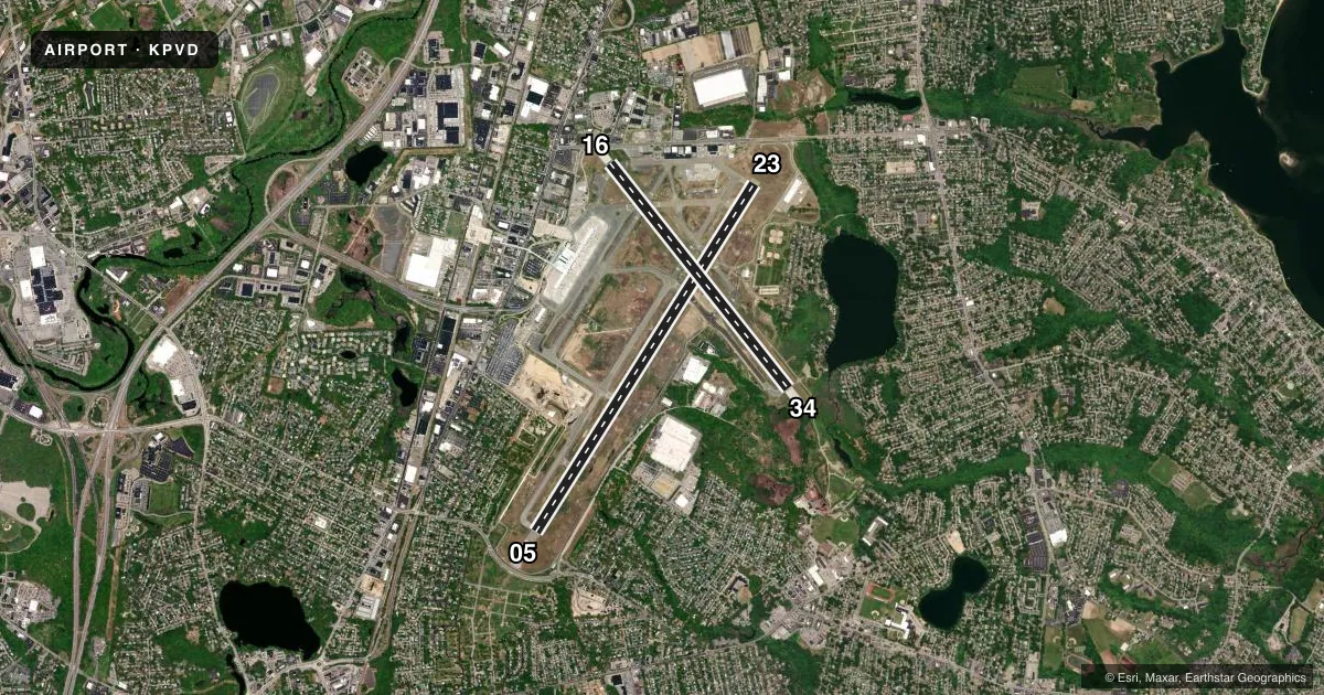
Runways & pattern
Full pagePattern entry · RWY 05
LEFT TRAFFIC| Runway | Heading (°M) | Length | Surface | Traffic |
|---|---|---|---|---|
| 05/23 | 17° / 197° | 8,700 ft | ASPH | Standard L |
| 16/34 | 127° / 307° | 6,081 ft | ASPH | Standard L |
Runway end performance
| End | TORA | TODA | ASDA | LDA | VGSI | Approach lights | Obstruction |
|---|---|---|---|---|---|---|---|
| 05 | 8,700' | 8,700' | 8,700' | 8,700' | PAPI 4-box right(3°) | ALSF2 | 56', trees, 2475' from thr, 600' R of cntrln, slope 40 |
| 23 | 8,700' | 8,700' | 8,700' | 8,700' | VASI 4-box left(3°) | MALSR | 50', trees, 2185' from thr, 790' R of cntrln, slope 39 |
| 16 | 6,081' | 6,081' | 6,081' | 5,516' | PAPI 4-box left(3°) | — | 19', pole, 560' from thr, 200' R of cntrln, slope 18 |
| 34 | 6,081' | 6,081' | 6,081' | 6,081' | PAPI 4-box left(3°) | MALSR | 39', trees, 1400' from thr, 300' R of cntrln, slope 30 |
Declared distances in feet. TORA = takeoff run available, TODA = takeoff distance, ASDA = accelerate-stop, LDA = landing distance.
Airport sketch
Runways drawn to scale from FAA survey coordinates, rendered over satellite imagery. Not for navigation.
Approaches & charts
ILS · 3
Services on the field
Fuel grades, oxygen, maintenance, ramp storage and lighting — as declared to the FAA by the airport operator.
Fuel & services
- Fuel
- 100LLA
- Oxygen (bottled)
- Not available
- Oxygen (bulk)
- Not available
- Airframe repair
- Major
- Power plant repair
- Major
- Other services
- AFRT,CARGO,CHTR,INSTR,RNTL,SALES
Ramp & ground
- Transient storage
- Tie-down
- Hangar
- Landing fee
- Yes
- Customs
- Not available
- Lighting schedule
- SEE RMK
- Beacon schedule
- SS-SR
- Beacon
- White / Green (civil land)(WG)
- Wind indicator
- Lighted
- Segmented circle
- Yes
Fuel & FBOs
Cheapest 100LL and Jet A on the field and nearby. Always confirm with the FBO before taxi.
Airport notes
Surface conditions, obstructions, local procedures, lighting outages and other notes published with each FAA cycle.
General notes
- GND VEHICLES MNT CTAF WHEN ATCT CLSD.
- DEER & BIRDS ON & INVOF ARPT.
- 110 FT UNMKD LGT POLES, 2700 FT FM THR RWY 34, 900 FT LEFT OF CNTRLN.
- RUN UP PAD FOR TWY F CLSD TO ACFT WITH WINGSPAN OVER 118 FT.
- NOISE ABATEMENT PROCS IN EFCT. HELS AVOID RESL AREAS WHEN BLW 1000 FT.
- NW RAMP ACFT WITH WINGSPAN GTR THAN 110 FT RQR GND CREW ASSISTANCE FOR THRU TAXI AND PRKG.
- TRML RAMP PROHIBITED FOR USE BY GA.
- TWY V CLSD DLY 2000-0800 BTN RWY 16/34 AND TWY C.
- PARKED ACFT ON THE NE RAMP WEST OF TWY A, BE ALERT. FQT FLT SCHOOL, TSNT JET ACFT, AND VER ACTVTY.
- NE RAMP ACFT WITH WINGSPAN GTR THAN 150 FT RQR GND CREW ASSISTANCE FOR THRU TAXI AND PRKG.
- FOR CD WHEN APCH CLSD CTC BOSTON ARTCC AT 603-879-6859.
- TWY A UNEVEN PAVEMENT BTN TWY M & RWY 23.
Lighting notes
- WHEN ATCT CLSD, ALSF-2 BCMS SSALS PRESET MED INTST ONLY. WHEN ATCT CLSD, ACTVT MALSR RWY 23 & 34; REIL RWY 16; PAPI RWY 05, 16 & 34; VASI RWY 23; TDZ RWY 05; CNTLN RWY 5/23; HIRL RWY 5/23 & 16/34 - CTAF.
Runway surface & condition
- 05/23PCR VALUE: 1010/F/A/X/T
- 16/34PCR VALUE: 780/F/B/X/T
Approach & departure obstructions
- 1654 FT TREES 700 FT R OF CNTRLN 2000 FT FM RWY END. 37:1 TO DTHR.
Arresting gear
- 16_EMASENGINEERED MATERIAL ARRESTING SYSTEM (EMAS) 462 FT IN LENGTH BY 178 FT IN WIDTH LCTD AT THE DER 16.
- 23_EMASENGINEERED MATERIAL ARRESTING SYSTEM (EMAS) 417 FT IN LENGTH BY 178 FT IN WIDTH LCTD AT THE DER 23.
- 34_EMASENGINEERED MATERIAL ARRESTING SYSTEM (EMAS) 255 FT IN LENGTH BY 170 FT IN WIDTH LCTD AT THE DER 34.
Other notes
- EXISTED PRIOR TO 1959.
VFR map & nearby airports
VFR sectional. Tap any ICAO chip to open that airport.
Key facts · KPVD
Answer card- ICAO
- KPVD
- Name
- RHODE ISLAND TF GREEN INTL
- Location
- PROVIDENCE, RHODE ISLAND
- Elevation
- 54 ft MSL
- Traffic pattern altitude
- 1,054 ft MSL (1,000 AGL)
- Control tower
- Towered · SUN-FRI 0530-0030 SAT 0530-0000
- Total runways
- 2
- Longest runway
- 05/23 · 8,700 ft
- Published ILS approaches
- 3
- Published frequencies
- 14
- Magnetic variation
- 15°
- Current flight rules
- VFR
- Current wind
- 000° at 0 kt
- Favored runway now
- –
Rhode Island TF Green Intl sits in Providence, Rhode Island. Field elevation is 54 ft MSL. The airport has two asphalt runways. The longest is 05/23 at 8,700 ft. Runway 16/34 is 6,081 ft. The tower is open Sun-Fri 0530-0030 and Sat 0530-0000. Three ILS approaches are published for runway ends 05, 23 and 34. Pattern altitude is not published in the facts block. Use 1,000 ft AGL for light piston traffic unless ATC or the current Chart Supplement says otherwise.
Atlantic Aviation is on the field. It carries 100LL and Jet A. Call them at (401) 738-2600 before arrival if you need ramp or fuel details. This is a busy Class C field with frequent flight school traffic and transient jets. Taxiway A has uneven pavement between taxiway M and runway 23. Taxiway V is closed daily from 2000 to 0800 between runway 16/34 and taxiway C. The northeast ramp also needs close attention because parked aircraft and large wingspans can make taxi more demanding. When the tower is closed, lighting is activated on CTAF. The airport also has EMAS at the departure ends of runways 16 and 34. Check the current Chart Supplement for any published noise or curfew restrictions before flying into the field.