METAR & TAF KOWB
Current METAR
Observed 10:56Z
KOWB 271056Z 31007KT 10SM CLR 22/22 A2992 RMK AO2 SLP128 T02220217
- Wind
- 310° @ 7 kt
- Visibility
- 10 SM
- Temp / Dew
- 22°C / 22°C
- Altimeter
- 29.92 inHg
- Clouds
- CLR
- Density alt
- 1,345 ft
- Ceiling
- Unlimited
- Rules
- VFR
Airport info & contacts
Manager on record, flight service, ARTCC, attendance schedule and pattern altitude — published by the FAA and refreshed every 28 days.
Location
- From city
- 3 NM SW
- VFR sectional
- ST LOUIS
- ARTCC
- ZID · INDIANAPOLIS
- NOTAM facility
- OWB (NOTAM-D)
Airport manager
- Name
- TRISTAN DURBIN
- Phone
- 270-685-4179
- Address
- 2200 AIRPORT ROAD, OWENSBORO KY 42303
Flight service · Hours
- FSS LOU
- LOUISVILLE1-800-WX-BRIEF
- Attendance
- 0600-2000
Frequencies
Tap any row to copy the frequency to your clipboard.
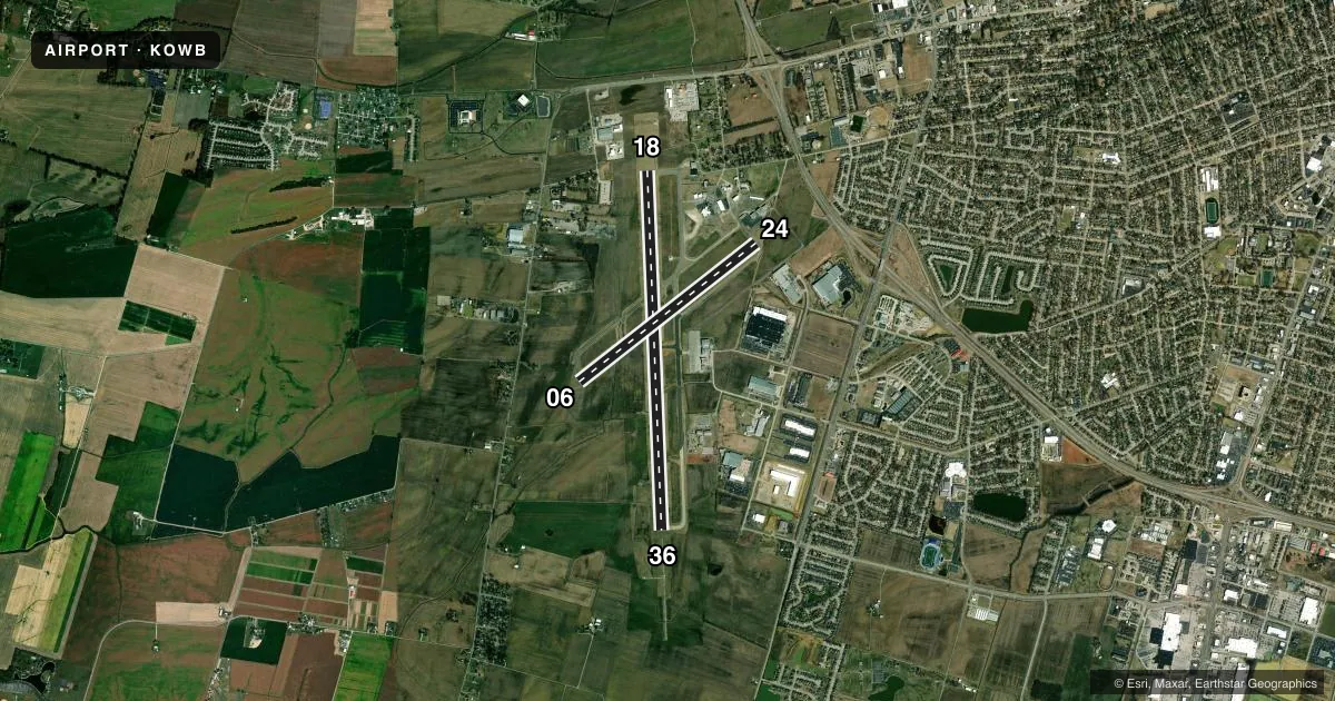
Runways & pattern
Full pagePattern entry · RWY 36
LEFT TRAFFIC| Runway | Heading (°M) | Length | Surface | Traffic |
|---|---|---|---|---|
| 18/36Favored | 174° / 354° | 8,000 ft | CONC | Standard L |
| 06/24 | 48° / 228° | 5,000 ft | ASPH-CONC | Standard L |
Runway end performance
| End | TORA | TODA | ASDA | LDA | VGSI | Approach lights | Obstruction |
|---|---|---|---|---|---|---|---|
| 18 | 8,000' | 8,000' | 8,000' | 8,000' | PAPI 4-box left(3°) | — | — |
| 36 | 8,000' | 8,000' | 8,000' | 8,000' | PAPI 4-box left(3°) | MALSR | — |
| 06 | 5,000' | 5,000' | 5,000' | 5,000' | PAPI 2-box left(3°) | — | — |
| 24 | 5,000' | 5,000' | 5,000' | 5,000' | PAPI 2-box left(3°) | — | — |
Declared distances in feet. TORA = takeoff run available, TODA = takeoff distance, ASDA = accelerate-stop, LDA = landing distance.
Airport sketch
Runways drawn to scale from FAA survey coordinates, rendered over satellite imagery. Not for navigation.
Approaches & charts
ILS · 1
Services on the field
Fuel grades, oxygen, maintenance, ramp storage and lighting — as declared to the FAA by the airport operator.
Fuel & services
- Fuel
- 100LLA
- Oxygen (bottled)
- Low pressure
- Airframe repair
- Major
- Power plant repair
- Major
- Other services
- AFRT,CHTR,INSTR
Ramp & ground
- Transient storage
- Tie-down
- Hangar
- Landing fee
- No fee published
- Customs
- Not available
- Lighting schedule
- SEE RMK
- Beacon schedule
- SS-SR
- Beacon
- White / Green (civil land)(WG)
- Wind indicator
- Lighted
- Segmented circle
- Yes
Fuel & FBOs
Cheapest 100LL and Jet A on the field and nearby. Always confirm with the FBO before taxi.
Airport notes
Surface conditions, obstructions, local procedures, lighting outages and other notes published with each FAA cycle.
General notes
- WILDLIFE & AGRICULTURE OPS ON & INVOF ARPT.
- FOR CD WHEN ATCT CLSD CTC EVANSVILLE APCH AT 812-436-4690, WHEN APCH CLSD CTC INDIANAPOLIS ARTCC AT 317-247-2411.
Lighting notes
- WHEN ATCT CLSD ACTVT MALSR RWY 36; REIL RWY 06, 18, 24; PAPI RWY 6, 18, 24, 36; MIRL RWY 6/24; HIRL RWY 18/36; TWY; WINDCONE - CTAF.
Runway surface & condition
- 06/24PCR VALUE: 180/R/C/W/T
- 18/36PCR VALUE: 470/R/C/W/T
- 06/24RWY 06/24 NOT AVBL FOR PART 121/PART 380 OPS WITH SKED PAX CARRYING OPS MORE THAN 9 PAX SEATS AND NON-SKED PAX CARRYING OPS MORE THAN 30 PAX SEATS.
Other notes
- EXISTED PRIOR TO 1959.
- PPR 24 HR FOR UNSKED ACR OPS WITH MORE THAN 30 PAX - AMGR.
VFR map & nearby airports
VFR sectional. Tap any ICAO chip to open that airport.
Key facts · KOWB
Answer card- ICAO
- KOWB
- Name
- OWENSBORO/DAVIESS COUNTY RGNL
- Location
- OWENSBORO, KENTUCKY
- Elevation
- 407.3 ft MSL
- Traffic pattern altitude
- 1,407.3 ft MSL (1,000 AGL)
- Control tower
- Towered · 0600-2200
- Total runways
- 2
- Longest runway
- 18/36 · 8,000 ft
- Published ILS approaches
- 1
- Published frequencies
- 9
- Magnetic variation
- 4°
- Current flight rules
- VFR
- Current wind
- 310° at 7 kt
- Favored runway now
- RWY 36
KOWB is in Owensboro, Kentucky. The field elevation is 407.3 ft MSL. It has two runways. The longest is 18/36 at 8,000 ft. The tower is open daily from 0600 to 2200. One ILS is published for runway 36.
Pattern altitude is not published in the facts. Use the standard 1,000 ft AGL pattern for light piston traffic unless ATC or the current Chart Supplement says otherwise. The airport sits in a busy part of western Kentucky. Wildlife and agriculture activity are both noted in the published remarks. Keep a sharp scan on arrival and departure.
MidAmerica Jet is on the field. It carries 100LL, Jet A and Jet A Prist. Owensboro-Daviess County Regional Airport is also on the field. It carries 100LL. When the tower is closed, lighting is available for both runways plus the approach lighting system and PAPI on the listed ends. Runway 06/24 is not available for certain large scheduled passenger operations. Prior permission is required 24 hours in advance for some unscheduled passenger flights with more than 30 passengers. Check the current Chart Supplement for any current airport restrictions before flying in.