METAR & TAF KOUN
Current METAR
Observed 16:45Z
KOUN 271645Z 18014KT 10SM CLR 34/19 A2992
- Wind
- 180° @ 14 kt
- Visibility
- 10 SM
- Temp / Dew
- 34°C / 19°C
- Altimeter
- 29.92 inHg
- Clouds
- CLR
- Density alt
- 3,745 ft
- Ceiling
- Unlimited
- Rules
- VFR
Airport info & contacts
Manager on record, flight service, ARTCC, attendance schedule and pattern altitude — published by the FAA and refreshed every 28 days.
Location
- From city
- 3 NM NW
- VFR sectional
- DALLAS-FT WORTH
- ARTCC
- ZFW · FORT WORTH
- NOTAM facility
- OUN (NOTAM-D)
Airport manager
- Name
- LANCE LAMKIN
- Phone
- 405-325-7233
- Address
- 1700 LEXINGTON AVE, SUITE 212, NORMAN OK 73069
Flight service · Hours
- FSS MLC
- MC ALESTER1-800-WX-BRIEF
- Attendance
- 0600-2200
Frequencies
Tap any row to copy the frequency to your clipboard.
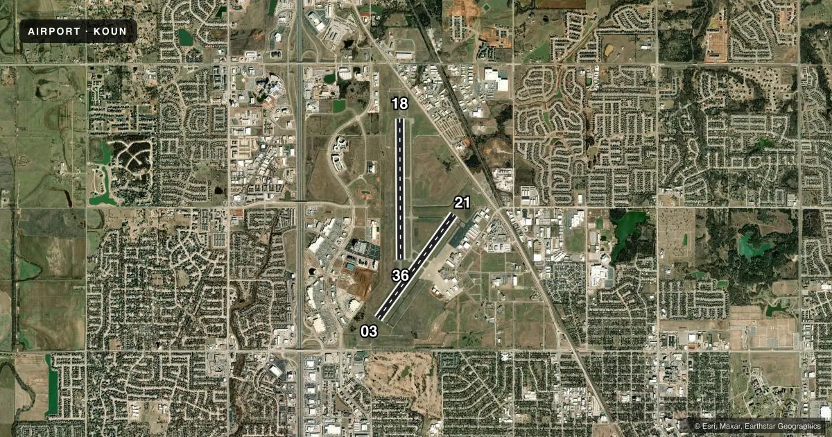
Runways & pattern
Full pagePattern entry · RWY 18
RIGHT TRAFFIC| Runway | Heading (°M) | Length | Surface | Traffic |
|---|---|---|---|---|
| 18/36Favored | 177° / 357° | 5,199 ft | ASPH | 18 R |
| 03/21 | 33° / 213° | 4,748 ft | ASPH | 21 R |
Runway end performance
| End | TORA | TODA | ASDA | LDA | VGSI | Approach lights | Obstruction |
|---|---|---|---|---|---|---|---|
| 18 | — | — | — | — | PAPI 4-box left(3°) | MALSR | — |
| 36 | — | — | — | — | PAPI 4-box left(3°) | — | — |
| 03 | — | — | — | — | PAPI 4-box left(3°) | MALS | — |
| 21 | — | — | — | — | PAPI 4-box left(3°) | — | — |
Declared distances in feet. TORA = takeoff run available, TODA = takeoff distance, ASDA = accelerate-stop, LDA = landing distance.
Airport sketch
Runways drawn to scale from FAA survey coordinates, rendered over satellite imagery. Not for navigation.
Approaches & charts
ILS · 2
Services on the field
Fuel grades, oxygen, maintenance, ramp storage and lighting — as declared to the FAA by the airport operator.
Fuel & services
- Fuel
- 100LLA+
- Oxygen (bottled)
- Not available
- Oxygen (bulk)
- Not available
- Airframe repair
- Major
- Power plant repair
- Major
- Other services
- AVNCS,INSTR,RNTL
Ramp & ground
- Transient storage
- Tie-down
- Hangar
- Landing fee
- Yes
- Customs
- Not available
- Lighting schedule
- SEE RMK
- Beacon schedule
- SS-SR
- Beacon
- White / Green (civil land)(WG)
- Wind indicator
- Lighted
- Segmented circle
- Yes
Fuel & FBOs
Cheapest 100LL and Jet A on the field and nearby. Always confirm with the FBO before taxi.
Airport notes
Surface conditions, obstructions, local procedures, lighting outages and other notes published with each FAA cycle.
General notes
- 180 DEG TURNS PROHIBITED ON RWYS FOR ALL OTHER THAN SINGLE ENGINE LIGHT ACFT.
- CTN: COYOTES & BIRDS ON & INVOF OF RWYS.
- HIGH DENSITY STUDENT OPNS INVOF ARPT & 5 MILES SOUTH.
- TPA FOR HELS 500 FT AGL; SINGLE ENGINE 1000 FT AGL; MULTI-ENGINE & JETS 1500 FT AGL.
- FOR CD IFUN TO CTC TWR, CTC OKE CITY APCH AT 405-681-5683.
- PPR RQRD ALL TSNT ACFT DAY BFR & DAY OF UNIVERSITY HOME FOOTBALL GAME AT 405-360-3900.
- PILOTS CONDUCTING EFVS OPS; BE AWARE LED ALS IN USE RWY 03.
Lighting notes
- WHEN ATCT CLSD ACTVT MIRL RYS 03/21 & 18/36; REIL RY 36;MALSR RY 18 & MALS RY 03 - CTAF.
Other notes
- THIS AIRPORT HAS BEEN SURVEYED BY THE NATIONAL GEODETIC SURVEY.
- PRE DATES THE ACT.
- SPL EVENT FEE FOR ALL ACFT THE DAY BEFORE AND DAY OF A UNIVERSITY HOME FOOTBALL GAME.
VFR map & nearby airports
VFR sectional. Tap any ICAO chip to open that airport.
Key facts · KOUN
Answer card- ICAO
- KOUN
- Name
- UNIVERSITY OF OKLAHOMA WESTHEIMER
- Location
- NORMAN, OKLAHOMA
- Elevation
- 1,181.7 ft MSL
- Traffic pattern altitude
- 2,181.7 ft MSL (1,000 AGL)
- Control tower
- Towered · 0800-2200
- Total runways
- 2
- Longest runway
- 18/36 · 5,199 ft
- Published ILS approaches
- 2
- Published frequencies
- 6
- Magnetic variation
- 3°
- Current flight rules
- VFR
- Current wind
- 180° at 14 kt
- Favored runway now
- RWY 18
University of Oklahoma Westheimer is in Norman, Oklahoma. Field elevation is 1,181.7 ft MSL. The airport has two asphalt runways. The longest is 18/36 at 5,199 ft. The tower is open 0800-2200. When the tower is closed, use CTAF 118.0 for lighting activation and traffic calls.
There are 2 ILS approaches. They serve runway ends 03 and 18. Pattern altitude is not published in the facts block. Use the standard 1,000 ft AGL for light piston aircraft unless the current Chart Supplement says otherwise. Published helicopter pattern altitude is 500 ft AGL. Single-engine aircraft use 1,000 ft AGL. Multi-engine aircraft and jets use 1,500 ft AGL.
Cruise Aviation is on the field. It carries 100LL and Jet A. Call (405) 360-3900 for current services. The remarks also note high-density student traffic in the area and five miles south. Expect that to matter on a busy day. There are also coyotes and birds on or near the runways. Keep a sharp scan on taxi, takeoff and landing. Special event fees and prior permission apply the day before and day of a university home football game. Check with the airport operator or the FBO directly before you go.