METAR & TAF KMOT
Current METAR
Observed 18:54Z
KMOT 271854Z VRB04KT 10SM CLR 31/17 A2989 RMK AO2 SLP110 T03060172
- Wind
- VAR @ 4 kt
- Visibility
- 10 SM
- Temp / Dew
- 31°C / 17°C
- Altimeter
- 29.89 inHg
- Clouds
- CLR
- Density alt
- 4,085 ft
- Ceiling
- Unlimited
- Rules
- VFR
Airport info & contacts
Manager on record, flight service, ARTCC, attendance schedule and pattern altitude — published by the FAA and refreshed every 28 days.
Location
- From city
- 2 NM N
- VFR sectional
- BILLINGS
- ARTCC
- ZMP · MINNEAPOLIS
- NOTAM facility
- MOT (NOTAM-D)
Airport manager
- Name
- JENNIFER ECKMAN
- Phone
- 701-857-4724
- Address
- 305 AIRPORT RD, SUITE 216, MINOT ND 58703
Flight service · Hours
- FSS GFK
- GRAND FORKS1-800-WX-BRIEF
- Attendance
- ALL
Frequencies
Tap any row to copy the frequency to your clipboard.
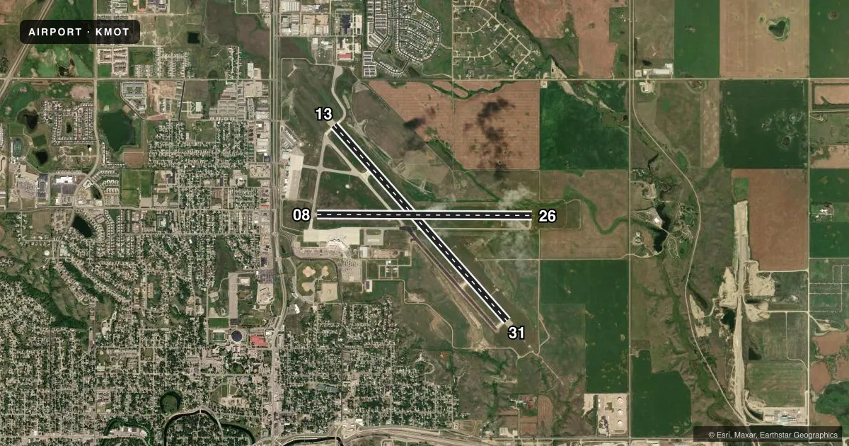
Runways & pattern
Full pagePattern entry · RWY 31
LEFT TRAFFIC| Runway | Heading (°M) | Length | Surface | Traffic |
|---|---|---|---|---|
| 13/31Favored | 132° / 312° | 7,700 ft | CONC | Standard L |
| 08/26 | 84° / 264° | 6,348 ft | ASPH | Standard L |
Runway end performance
| End | TORA | TODA | ASDA | LDA | VGSI | Approach lights | Obstruction |
|---|---|---|---|---|---|---|---|
| 13 | 7,700' | 7,700' | 7,700' | 7,700' | PAPI 4-box left(3°) | — | — |
| 31 | 7,700' | 7,700' | 7,700' | 7,700' | — | MALSR | — |
| 08 | 6,348' | 6,348' | 6,348' | 5,958' | PAPI 4-box left(3°) | — | 57', trees, 1790' from thr, 460' R of cntrln, slope 27 |
| 26 | 5,958' | 5,958' | 6,348' | 6,348' | PAPI 4-box left(3°) | — | — |
Declared distances in feet. TORA = takeoff run available, TODA = takeoff distance, ASDA = accelerate-stop, LDA = landing distance.
Airport sketch
Runways drawn to scale from FAA survey coordinates, rendered over satellite imagery. Not for navigation.
Approaches & charts
ILS · 1
Services on the field
Fuel grades, oxygen, maintenance, ramp storage and lighting — as declared to the FAA by the airport operator.
Fuel & services
- Fuel
- 100LLA
- Oxygen (bottled)
- High pressure
- Airframe repair
- Major
- Power plant repair
- Major
- Other services
- AGRI,AMB,AVNCS,CHTR,INSTR,RNTL,SALES
Ramp & ground
- Transient storage
- Tie-down
- Landing fee
- Yes
- Customs
- Available
- Lighting schedule
- SEE RMK
- Beacon schedule
- SS-SR
- Beacon
- White / Green (civil land)(WG)
- Wind indicator
- Lighted
- Segmented circle
- Yes
Fuel & FBOs
Cheapest 100LL and Jet A on the field and nearby. Always confirm with the FBO before taxi.
Airport notes
Surface conditions, obstructions, local procedures, lighting outages and other notes published with each FAA cycle.
General notes
- DEER & BIRDS INVOF ARPT.
- TWYS E, B2, F, AND A ARE MKD WITH EDGE REFLECTORS.
- CUSTOMS SVC AVBL 24 HRS; FOR CUSTOMS CALL 701-838-6704.
- MINOT AFB (MIB) ASR OTS FOR PREVENTIVE MAINTENANCE FRIDAYS 0700-0900 & ALTN TUESDAYS 0630-0830.
- RDO EQUIPD ACFT MUST ANNC ON CTAF - 118.2 WHEN TWR IS CLSD.
- FOR CD IF UNA TO CTC ON FSS FREQ, CTC MINNEAPOLIS ARTCC AT 651-463-5588.
- AIRFIELD STD TFC PATTERN ALT 1000 FT; OVERFLY ALT 1500 FT.
- WHEN ATCT CLSD CTC - CTAF.
Lighting notes
- WHEN ATCT IS CLSD, ACTVT MALSR RWY 31; REIL RWYS 08 & 26; HIRL RWYS 08/26 & 13/31 - CTAF. PAPI RWYS 08, 13, & 26 OPR CONSLY.
Runway surface & condition
- 08/26PCR VALUE: 320/F/C/X/T
- 13/31PCR VALUE: 500/R/C/W/T
Approach & departure obstructions
- 08RWY 08 APCH RATIO 32:1 FM DSPLCD THLD.
Other notes
- LDG FEE FOR ALL COML FREIGHT AND COMMUTER ACFT AND ALL ACFT OVR 12500 LB.
VFR map & nearby airports
VFR sectional. Tap any ICAO chip to open that airport.
Key facts · KMOT
Answer card- ICAO
- KMOT
- Name
- MINOT INTL
- Location
- MINOT, NORTH DAKOTA
- Elevation
- 1,715.7 ft MSL
- Traffic pattern altitude
- 2,715.7 ft MSL (1,000 AGL)
- Control tower
- Towered · 0700-2200
- Total runways
- 2
- Longest runway
- 13/31 · 7,700 ft
- Published ILS approaches
- 1
- Published frequencies
- 8
- Magnetic variation
- 6°
- Current flight rules
- VFR
- Current wind
- 000° at 4 kt
- Favored runway now
- RWY 31
Minot Intl is in Minot, North Dakota. The field elevation is 1,715.7 ft MSL. It has two runways. The longest is 13/31 at 7,700 ft. Runway 08/26 is 6,348 ft. The tower is open daily from 0700 to 2200. One ILS is published for runway 31.
The standard traffic pattern altitude is 1,000 ft AGL. That puts the pattern at 2,715.7 ft MSL. Avflight Minot is the on-field FBO. It carries 100LL, Jet A and Jet A Prist. If you are planning a stop, that covers the fuel options confirmed in the facts.
A few operational items matter here. The airport sits in Minot. Expect a busy controlled environment when the tower is open. When the tower is closed, radio-equipped aircraft must announce on CTAF 118.2. The published remarks also call out deer and birds in the area. Runway 08 has a noted approach clearance slope from the displaced threshold. Taxiway edge reflectors are marked on E, B2, F and A. If you need current noise, curfew, or airspace details beyond what is listed here, check the current FAA Chart Supplement before you go.