METAR & TAF KMMU
Current METAR
Observed 12:50Z
KMMU 271250Z 00000KT 10SM SKC 24/19 A2985
- Wind
- 000° @ 0 kt
- Visibility
- 10 SM
- Temp / Dew
- 24°C / 19°C
- Altimeter
- 29.85 inHg
- Clouds
- SKC
- Density alt
- 1,398 ft
- Ceiling
- Unlimited
- Rules
- VFR
Airport info & contacts
Manager on record, flight service, ARTCC, attendance schedule and pattern altitude — published by the FAA and refreshed every 28 days.
Location
- From city
- 3 NM E
- VFR sectional
- NEW YORK
- ARTCC
- ZNY · NEW YORK
- NOTAM facility
- MMU (NOTAM-D)
Airport manager
- Name
- SCOTT MCMAHON
- Phone
- 973-538-6400
- Address
- DM AIRPORTS, LTD., 8 AIRPORT ROAD, MORRISTOWN NJ 07960
Flight service · Hours
- FSS MIV
- MILLVILLE1-800-WX-BRIEF
- Attendance
- 0645-2230
Frequencies
Tap any row to copy the frequency to your clipboard.
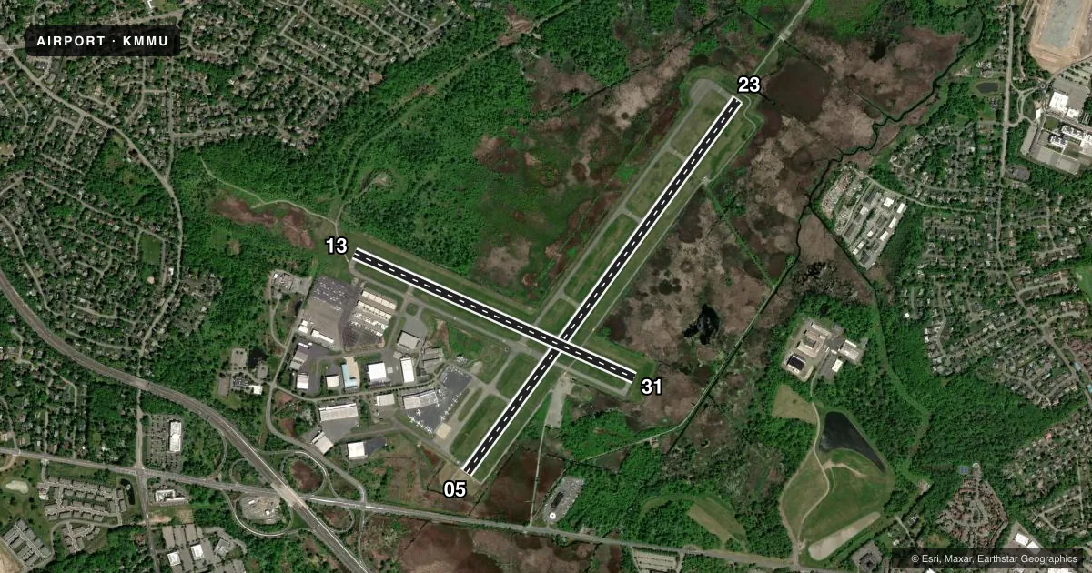
Runways & pattern
Full pagePattern entry · RWY 05
LEFT TRAFFIC| Runway | Heading (°M) | Length | Surface | Traffic |
|---|---|---|---|---|
| 05/23 | 23° / 203° | 5,998 ft | ASPH | Standard L |
| 13/31 | 101° / 281° | 3,997 ft | ASPH | Standard L |
Runway end performance
| End | TORA | TODA | ASDA | LDA | VGSI | Approach lights | Obstruction |
|---|---|---|---|---|---|---|---|
| 05 | — | — | — | — | — | — | 102', trees, 2100' from thr, 0' R of cntrln, slope 18 |
| 23 | — | — | — | — | — | MALSR | — |
| 13 | — | — | — | — | — | — | 49', trees, 320' from thr, 240' R of cntrln, slope 2 |
| 31 | — | — | — | — | PAPI 2-box left(3.5°) | — | 91', trees, 1690' from thr, 330' R of cntrln, slope 16 |
Declared distances in feet. TORA = takeoff run available, TODA = takeoff distance, ASDA = accelerate-stop, LDA = landing distance.
Airport sketch
Runways drawn to scale from FAA survey coordinates, rendered over satellite imagery. Not for navigation.
Approaches & charts
ILS · 1
Services on the field
Fuel grades, oxygen, maintenance, ramp storage and lighting — as declared to the FAA by the airport operator.
Fuel & services
- Fuel
- 100LLAA+
- Oxygen (bottled)
- HIGH/LOW
- Oxygen (bulk)
- HIGH/LOW
- Airframe repair
- Not available
- Power plant repair
- Not available
- Other services
- CHTR,INSTR,RNTL
Ramp & ground
- Transient storage
- Tie-down
- Hangar
- Landing fee
- Yes
- Customs
- Not available
- Lighting schedule
- SEE RMK
- Beacon schedule
- SS-SR
- Beacon
- White / Green (civil land)(WG)
- Wind indicator
- Lighted
- Segmented circle
- Yes
Fuel & FBOs
Cheapest 100LL and Jet A on the field and nearby. Always confirm with the FBO before taxi.
Airport notes
Surface conditions, obstructions, local procedures, lighting outages and other notes published with each FAA cycle.
General notes
- BIRDS & DEER ON & INVOF ARPT.
- NOISE ABATEMENT PROC IN EFCT; CTC NOISE ABATEMENT OFFICE 973-538-3366 EXTN 122.
- US CUSTOMS AVBL MON-FRI 0800-1600; BTN 1601-0759 & WKENDS CALL 973-267-0302 FOR APPOINTMENT. MORRISTOWN CUSTOMS ASSOCIATION FEES APPLY; CTC AMGR 973-538-6400 FOR DETAILS.
- NO TURBOJET LNDG ON RWY 13 & 31 UNLESS THE X-WIND VELOCITY FOR RWY 5/23 EXCEEDS 16 KNOTS.
- ACFT CARRYING EXPLOSIVE CARGO PPR BEFORE LDG - CALL 973-538-6400.
- FLIGHT NOTIFICATION SVC (ADCUS) AVBL.
- U.S. CUSTOMS USER FEE ARPT.
- ARFF SVCS AVBL 24 HRS DAILY. FOR ARFF SVCS WHEN ATCT CLSD CTC ARFF STATION; CTAF OR 973-455-1953.
- ALL ARRIVAL/DEPARTURE ACFT FOLLOW MANUFACTURERS RECOMMENDED PROCEDURES FOR QUIET OPNS & MINIMUM NOISE.
- ROUTE 80 VISUAL APCH PREFERRED FOR RY 23.
- HELICOPTER OPNS OVER RESIDENTIAL AREAS BLO 1000 FT MSL SHOULD BE AVOIDED.
- STAGE I DEPARTURE FEE 2300-0645.
- DURG SNOW REMOVAL OPNS 15 MINUTE PRIOR NOTICE REQUIRED ON 118.1 & NO PRACTICE LOW APCHS OR TOUCH & GO LDGS.
- INBOUND TFC REQUEST FBO SVCS, INSTRUCTIONS & RAMP ADVISORIES 30 MINUTES PRIOR TO ARRIVAL. AFTER LDG CTC FBO AGAIN 129.6 FOR PREFERRED RAMP ENTRANCE TO DELTA OR JULIET TWYS.
- VOLUNTARY NOISE ABATEMENT PROC INCLUDE AVOIDING TGL OPS ON RWY 13-31.
- FOR CD WHEN ATCT IS CLSD CTC NEWARK APCH AT 800-645-3206.
- NO TGL ON RWY 13/31 UNLESS THE CROSSWIND VLCTY FOR RWY 05/23 EXCEEDS 10 KTS.
- TAXILANE K BTN ATLANTIC FBO RAMP AND TAXIWAY L, NO HEL OR ACFT WITH A WINGSPAN GTR THAN 79 FT.
Lighting notes
- DUSK-DAWN; ACTVT HIRL RWY 05/23, MIRL RW 13/31, REIL RWY 05 & 31, MALSR RWY 23 & PAPI RWY 31 - CTAF.
Fuel notes
- AO-128 AVOIL AVBL.
Other notes
- WHEN TWR CLSD ALL ACFT AND VEHICLES MUST STATE INTNS ON CTAF BFR OPS ON ANY RWY.
- TPA 1013 LIGHT ACFT, 1513 HEAVY ACFT.
VFR map & nearby airports
VFR sectional. Tap any ICAO chip to open that airport.
Key facts · KMMU
Answer card- ICAO
- KMMU
- Name
- MORRISTOWN MUNI
- Location
- MORRISTOWN, NEW JERSEY
- Elevation
- 186.6 ft MSL
- Traffic pattern altitude
- 1,186.6 ft MSL (1,000 AGL)
- Control tower
- Towered · 0645-2230
- Total runways
- 2
- Longest runway
- 05/23 · 5,998 ft
- Published ILS approaches
- 1
- Published frequencies
- 11
- Magnetic variation
- 13°
- Current flight rules
- VFR
- Current wind
- 000° at 0 kt
- Favored runway now
- –
Morristown Muni is in Morristown, New Jersey. The field elevation is 186.6 ft MSL. It has two asphalt runways. The longest is runway 05/23 at 5,998 ft. Runway 13/31 is 3,997 ft. The tower is open daily from 0645 to 2230.
This airport has one ILS approach on runway 23. Pattern altitude is 1,013 ft MSL for light aircraft. Heavy aircraft use 1,513 ft MSL. Expect a busy controlled field with noise abatement in effect. The airport also publishes that it is a U.S. Customs user fee airport. Birds and deer are reported on and near the airport. Keep a sharp scan on taxi, takeoff and landing.
On the field, Signature Aviation carries 100LL and Jet A. Atlantic Aviation also carries 100LL and Jet A. Inbound traffic should call for FBO services, instructions and ramp advisories 30 minutes before arrival. After landing, contact the FBO again on frequency 129.6 for the preferred ramp entrance to Delta or Juliet taxiways. At night, runway 05/23 has high intensity lighting. Runway 13/31 has medium intensity lighting. If the tower is closed, make all intentions on CTAF before moving on any runway. Check the current FAA Chart Supplement for any current noise or operational restrictions before flying in.