METAR & TAF KMHV
Current METAR
Observed 11:55Z
KMHV 271155Z AUTO VRB03KT 10SM CLR 26/05 A2998 RMK AO2 T02570051 10281 20256 57002
- Wind
- VAR @ 3 kt
- Visibility
- 10 SM
- Temp / Dew
- 26°C / 5°C
- Altimeter
- 29.98 inHg
- Clouds
- CLR
- Density alt
- 4,719 ft
- Ceiling
- Unlimited
- Rules
- VFR
Airport info & contacts
Manager on record, flight service, ARTCC, attendance schedule and pattern altitude — published by the FAA and refreshed every 28 days.
Location
- From city
- 1 NM E
- VFR sectional
- LOS ANGELES
- ARTCC
- ZLA · LOS ANGELES
- NOTAM facility
- MHV (NOTAM-D)
Airport manager
- Name
- DAVID SMITH
- Phone
- 661-824-2433
- Address
- 1434 FLIGHTLINE, MOJAVE CA 93501
Flight service · Hours
- FSS RAL
- RIVERSIDE1-800-WX-BRIEF
- Attendance
- ALL
Frequencies
Tap any row to copy the frequency to your clipboard.
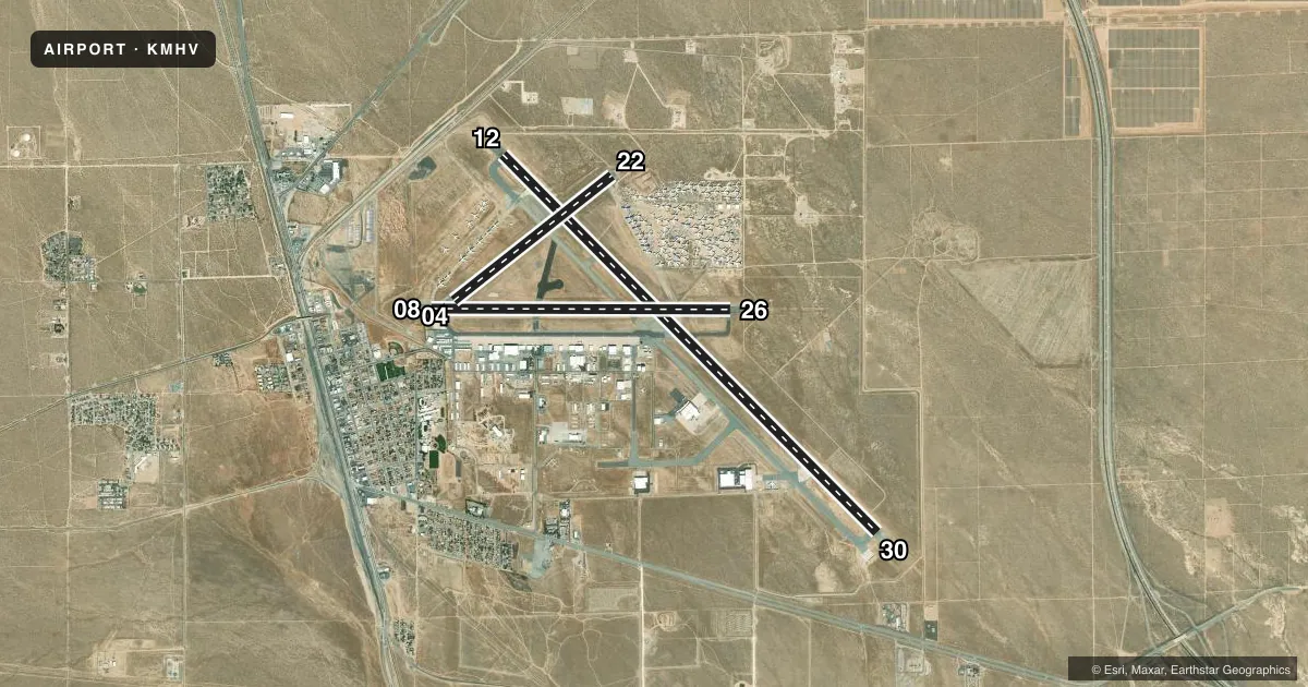
Runways & pattern
Full pagePattern entry · RWY 30
RIGHT TRAFFIC| Runway | Heading (°M) | Length | Surface | Traffic |
|---|---|---|---|---|
| 12/30Favored | 121° / 301° | 12,503 ft | ASPH | 30 R |
| 08/26 | 76° / 256° | 7,049 ft | ASPH | 26 R |
| 04/22 | 38° / 218° | 4,747 ft | ASPH | 22 R |
Runway end performance
| End | TORA | TODA | ASDA | LDA | VGSI | Approach lights | Obstruction |
|---|---|---|---|---|---|---|---|
| 12 | — | — | — | — | PAPI 4-box left(3.5°) | — | 375', other, 14400' from thr, 250' R of cntrln, slope 37 |
| 30 | — | — | — | — | PAPI 4-box left(3°) | — | — |
| 08 | — | — | — | — | PAPI 2-box left(4°) | — | — |
| 26 | — | — | — | — | PAPI 2-box left(3°) | — | — |
| 04 | — | — | — | — | PAPI 2-box left(4°) | — | 44', pole, 2200' from thr, 0' R of cntrln, slope 45 |
| 22 | — | — | — | — | PAPI 2-box left(3°) | — | — |
Declared distances in feet. TORA = takeoff run available, TODA = takeoff distance, ASDA = accelerate-stop, LDA = landing distance.
Airport sketch
Runways drawn to scale from FAA survey coordinates, rendered over satellite imagery. Not for navigation.
Approaches & charts
Services on the field
Fuel grades, oxygen, maintenance, ramp storage and lighting — as declared to the FAA by the airport operator.
Fuel & services
- Fuel
- 100LLAA+
- Oxygen (bottled)
- Not available
- Oxygen (bulk)
- Not available
- Airframe repair
- Major
- Power plant repair
- Major
- Other services
- AVNCS,INSTR
Ramp & ground
- Transient storage
- Tie-down
- Landing fee
- No fee published
- Customs
- Not available
- Lighting schedule
- SEE RMK
- Beacon schedule
- SS-SR
- Beacon
- White / Green (civil land)(WG)
- Wind indicator
- Lighted
- Segmented circle
- Yes
Fuel & FBOs
Cheapest 100LL and Jet A on the field and nearby. Always confirm with the FBO before taxi.
Airport notes
Surface conditions, obstructions, local procedures, lighting outages and other notes published with each FAA cycle.
General notes
- BE ALERT TO HIGH SPEED ACTIVITY INVOF ARPT.
- DUE TO RAPIDLY RISING TERRAIN AND WIND TURBINES W - NW OF ARPT, CAT C/D & ALL TURBOJET ACFT LDG RWY 8 MUST REMAIN AT OR ABOVE 4301 FT MSL UNTIL COMMENCING BASE LEG TURN AND AT OR ABOVE 3800 FT MSL UNTIL ESTABLISHED ON A 2.25 NM FINAL.
- TWY F IS CLSD WEST OF TWY A.
Lighting notes
- ACTVT REIL RWYS 12 & 30; MIRL RWYS 08/26 & 04/22; HIRL RWY 12/30 - CTAF.
Fuel notes
- 100LLFUEL AVBL 0700-1700, MON-SAT. OTR TIMES CTC ARPT OPNS ON CTAF OR CALL 661-824-2434; FEE CHARGED.
- A+FUEL AVBL 0700-1700, MON-SAT. OTR TIMES CTC ARPT OPNS ON CTAF OR CALL 661-824-2434; FEE CHARGED.
Runway surface & condition
- 08/26300 FT PAVED OVERRUN EAST END OF RY; 300 FT PAVED OVERRUN WEST END OF RY.
Approach & departure obstructions
- 12PAPI UNUSBL BYD 2.5 NM.
- 12APPROACH SLOPE 40:1 TO THE DSPLCD THR.
- 12WIND TURBINE
Other notes
- CAT C/D & ALL TBJT ACFT TPA 4301 FT MSL (1500 FT AGL); CAT A/B ACFT TPA 3801 FT MSL (1000 FT AGL); HEL TPA 3301 FT MSL (500 FT AGL) AND USE SOUTH ENTRY AND DEP.
VFR map & nearby airports
VFR sectional. Tap any ICAO chip to open that airport.
Key facts · KMHV
Answer card- ICAO
- KMHV
- Name
- MOJAVE AIR & SPACE PORT/RUTAN FLD
- Location
- MOJAVE, CALIFORNIA
- Elevation
- 2,801.3 ft MSL
- Traffic pattern altitude
- 3,801.3 ft MSL (1,000 AGL)
- Control tower
- Towered · 0700-1700 MON-FRI
- Total runways
- 3
- Longest runway
- 12/30 · 12,503 ft
- Published ILS approaches
- 0
- Published frequencies
- 6
- Magnetic variation
- 14°
- Current flight rules
- VFR
- Current wind
- 000° at 3 kt
- Favored runway now
- RWY 30
KMHV is Mojave Air & Space Port / Rutan Field in Mojave, California. The field elevation is 2,801.3 ft MSL. It has three asphalt runways. The longest is 12,503 ft on 12/30. The airport has a control tower. Tower hours are 0700-1700 Monday through Friday. No ILS approaches are published.
Pattern altitude is not published as a single value. Use the published category-specific traffic pattern altitudes. Category A and B aircraft use 3,801 ft MSL. Category C and D aircraft use 4,301 ft MSL. Helicopters use 3,301 ft MSL and use south entry and departure. That matters here because the field sits high. The area has rapidly rising terrain and wind turbines west to northwest of the airport. Runway 8 has a published arrival restriction for Category C and D aircraft and all turbojets. Taxiway F is closed west of Taxiway A.
The on-field FBO is Mojave Air & Space Port at Rutan Field. It carries 100LL, Jet A and Jet A Prist. Fuel is available from 0700 to 1700 Monday through Saturday. For other times, contact airport operations on CTAF or call the field directly. Runway 12 and 30 lighting includes REIL and high intensity lighting. Runway 08/26 and 04/22 have medium intensity runway lighting. Be alert for high speed activity in the airport area.