METAR & TAF KMGG
Current METAR
Observed 00:35Z
KMGG 280035Z AUTO 02006KT 10SM CLR 31/22 A2978 RMK AO2 T03100215
- Wind
- 020° @ 6 kt
- Visibility
- 10 SM
- Temp / Dew
- 31°C / 22°C
- Altimeter
- 29.78 inHg
- Clouds
- CLR
- Density alt
- 3,368 ft
- Ceiling
- Unlimited
- Rules
- VFR
Airport info & contacts
Manager on record, flight service, ARTCC, attendance schedule and pattern altitude — published by the FAA and refreshed every 28 days.
Location
- From city
- 1 NM NE
- VFR sectional
- TWIN CITIES
- ARTCC
- ZMP · MINNEAPOLIS
- NOTAM facility
- MGG (NOTAM-D)
Airport manager
- Name
- ALAN HUDEK
- Phone
- 612-490-8461
- Address
- PO BOX 757, 10 MAPLE AVE S, MAPLE LAKE MN 55358
Flight service · Hours
- FSS PNM
- PRINCETON1-800-WX-BRIEF
- Attendance
- Unattended
Frequencies
Tap any row to copy the frequency to your clipboard.
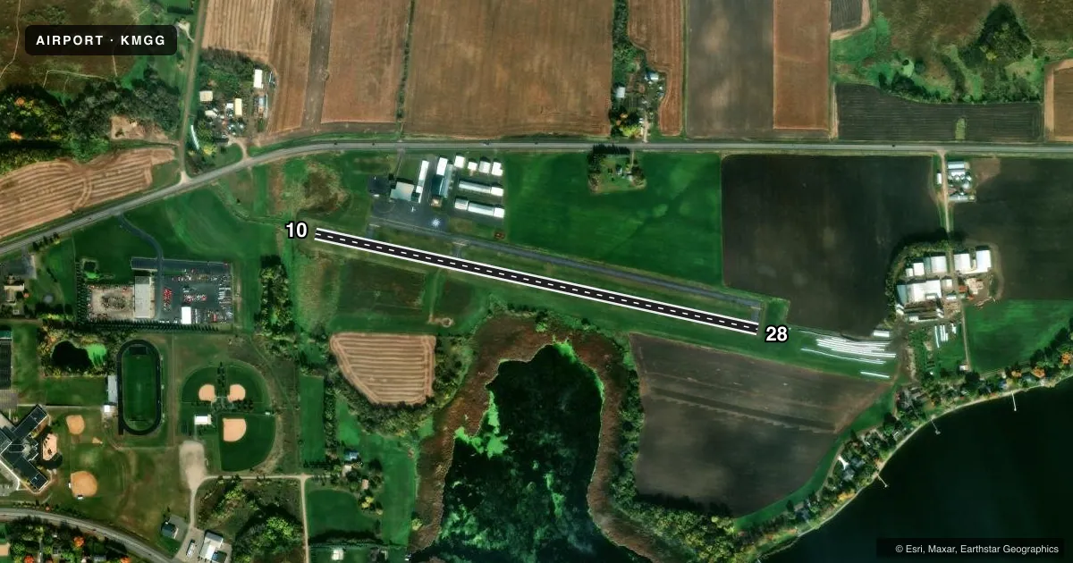
Runways & pattern
Full pagePattern entry · RWY 10
LEFT TRAFFICRunway end performance
| End | TORA | TODA | ASDA | LDA | VGSI | Approach lights | Obstruction |
|---|---|---|---|---|---|---|---|
| 10 | — | — | — | — | — | — | 39', pline, 535' from thr, 143' R of cntrln, slope 8 |
| 28 | — | — | — | — | — | — | 40', trees, 822' from thr, 176' R of cntrln, slope 15 |
Declared distances in feet. TORA = takeoff run available, TODA = takeoff distance, ASDA = accelerate-stop, LDA = landing distance.
Airport sketch
Runways drawn to scale from FAA survey coordinates, rendered over satellite imagery. Not for navigation.
Approaches & charts
Services on the field
Fuel grades, oxygen, maintenance, ramp storage and lighting — as declared to the FAA by the airport operator.
Fuel & services
- Fuel
- 100LL
- Oxygen (bottled)
- Not available
- Oxygen (bulk)
- Not available
- Airframe repair
- Not available
- Power plant repair
- Not available
Ramp & ground
- Transient storage
- Tie-down
- Landing fee
- No fee published
- Customs
- Not available
- Lighting schedule
- SS-SR
- Beacon schedule
- SS-SR
- Beacon
- White / Green (civil land)(WG)
- Wind indicator
- Lighted
- Segmented circle
- No
Fuel & FBOs
Cheapest 100LL and Jet A on the field and nearby. Always confirm with the FBO before taxi.
Airport notes
Surface conditions, obstructions, local procedures, lighting outages and other notes published with each FAA cycle.
General notes
- ONE TKOF/LDG PER FLT OPRN, NO TGL OR TRG.
- MIGRATORY WATERFOWL ON & INVOF ARPT.
- FOR CD CTC MINNEAPOLIS APCH AT 612-713-4016.
Fuel notes
- 100LLFUEL AVBL H24 WITH CREDIT CARD.
Runway surface & condition
- 10/28NSTD LIRL DUE TO 400 FT SPACING BTN LGTS, 20 FT FM EDGE.
Approach & departure obstructions
- 28+8 FT RSG TRRN, 170 FT DIST, 80 FT R.
Other notes
- MANAGEROR 612-490-8459.
- OWNERLEEANN.YAGER@CI.MAPLE-LAKE.MN.US.
VFR map & nearby airports
VFR sectional. Tap any ICAO chip to open that airport.
Key facts · KMGG
Answer card- ICAO
- KMGG
- Name
- MAPLE LAKE MUNI-BILL MAVENCAMP SR FLD
- Location
- MAPLE LAKE, MINNESOTA
- Elevation
- 1,028 ft MSL
- Traffic pattern altitude
- 2,028 ft MSL (1,000 AGL)
- Control tower
- Non-towered (use CTAF)
- Total runways
- 1
- Longest runway
- 10/28 · 2,796 ft
- Published ILS approaches
- 0
- Published frequencies
- 4
- Magnetic variation
- 3°
- Current flight rules
- VFR
- Current wind
- 020° at 6 kt
- Favored runway now
- RWY 10
Maple Lake Muni-Bill Mavencamp Sr Fld is in Maple Lake, Minnesota. The field elevation is 1,028 ft MSL. It has one runway. Runway 10/28 is 2,796 ft asphalt, so plan for a short-field mindset if you are bringing in a heavier airplane. There is no control tower. CTAF and UNICOM are both 122.8. Minneapolis Approach uses 126.5 and 335.65 for approach and departure. Clearance delivery is handled through Minneapolis Approach at 612-726-9086.
No ILS approaches are published here. Pattern altitude is not published in the facts, so use the standard 1,000 ft AGL for light piston operations unless the current FAA Chart Supplement says otherwise. The on-field FBO is Maple Lake Municipal Airport. It carries 100LL. Fuel is available 24 hours a day with credit card. The runway lights are nonstandard low-intensity lights because of the 400-foot spacing and the 20-foot offset from the edge.
A first-time pilot should also watch for migratory waterfowl in and around the airport. There is an 8-foot rising terrain feature near runway 28, 170 ft from the threshold and 80 ft right of centerline. Only one takeoff or landing per flight operation is permitted. No touch-and-go or training operations are allowed. Check the current Chart Supplement before you go for any changes or local procedures.