METAR & TAF KMEM
Current METAR
Observed 15:54Z
KMEM 271554Z 20007KT 150V210 10SM CLR 32/23 A2994 RMK AO2 SLP134 T03220233 $
- Wind
- 200° @ 7 kt
- Visibility
- 10 SM
- Temp / Dew
- 32°C / 23°C
- Altimeter
- 29.94 inHg
- Clouds
- CLR
- Density alt
- 2,438 ft
- Ceiling
- Unlimited
- Rules
- VFR
Airport info & contacts
Manager on record, flight service, ARTCC, attendance schedule and pattern altitude — published by the FAA and refreshed every 28 days.
Location
- From city
- 3 NM S
- VFR sectional
- MEMPHIS
- ARTCC
- ZME · MEMPHIS
- NOTAM facility
- MEM (NOTAM-D)
Airport manager
- Name
- TERRY BLUE
- Phone
- 901-922-8000
- Address
- 2491 WINCHESTER RD., SUITE 113, MEMPHIS TN 38116-3856
Flight service · Hours
- FSS MKL
- JACKSON1-800-WX-BRIEF
- Attendance
- ALL
Frequencies
Tap any row to copy the frequency to your clipboard.
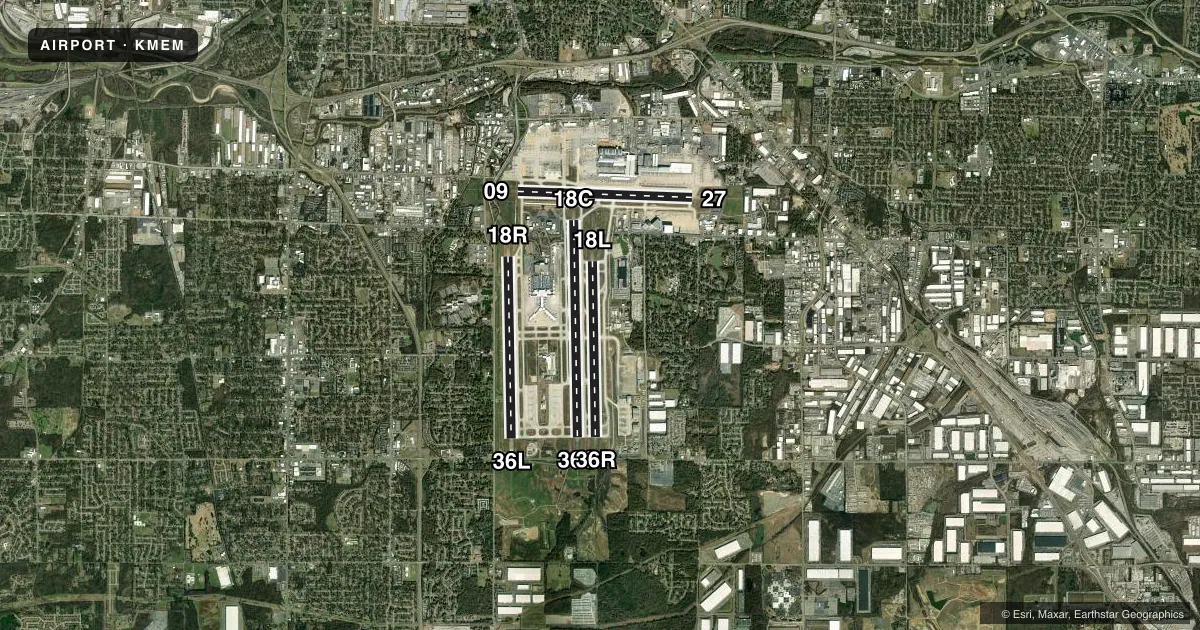
Runways & pattern
Full pagePattern entry · RWY 18C
LEFT TRAFFIC| Runway | Heading (°M) | Length | Surface | Traffic |
|---|---|---|---|---|
| 18C/36CFavored | 178° / 358° | 11,120 ft | CONC | 36C R |
| 18R/36L | 178° / 358° | 9,320 ft | CONC | 18R R |
| 18L/36R | 178° / 358° | 9,000 ft | CONC | Standard L |
| 09/27 | 91° / 271° | 8,946 ft | CONC | Standard L |
Runway end performance
| End | TORA | TODA | ASDA | LDA | VGSI | Approach lights | Obstruction |
|---|---|---|---|---|---|---|---|
| 18C | 11,120' | 11,120' | 11,120' | 11,120' | — | MALSR | 64', pole, 2593' from thr, 804' R of cntrln, slope 37 |
| 36C | 11,120' | 11,120' | 10,715' | 10,715' | PAPI 4-box left(3°) | ALSF2 | 36', tree, 1849' from thr, 745' R of cntrln, slope 45 |
| 18R | 9,320' | 9,320' | 9,320' | 9,320' | — | MALSR | — |
| 36L | 9,320' | 9,320' | 9,320' | 9,320' | PAPI 4-box left(3°) | ALSF2 | 30', tree, 1284' from thr, 662' R of cntrln, slope 36 |
| 18L | 9,000' | 9,000' | 9,000' | 9,000' | PAPI 4-box left(3°) | MALSR | — |
| 36R | 9,000' | 9,000' | 9,000' | 9,000' | PAPI 4-box right(3°) | ALSF2 | 101', trees, 2780' from thr, 739' R of cntrln, slope 25 |
| 09 | 8,946' | 8,946' | 8,946' | 8,946' | — | MALSR | 27', pole, 1243' from thr, 607' R of cntrln, slope 38 |
| 27 | 8,946' | 8,946' | 8,946' | 8,946' | PAPI 4-box left(3°) | MALSR | 50', pole, 1707' from thr, 662' R of cntrln, slope 30 |
Declared distances in feet. TORA = takeoff run available, TODA = takeoff distance, ASDA = accelerate-stop, LDA = landing distance.
Airport sketch
Runways drawn to scale from FAA survey coordinates, rendered over satellite imagery. Not for navigation.
Approaches & charts
ILS · 8
Services on the field
Fuel grades, oxygen, maintenance, ramp storage and lighting — as declared to the FAA by the airport operator.
Fuel & services
- Fuel
- 100LLAA+A++
- Oxygen (bulk)
- HIGH/LOW
- Airframe repair
- Major
- Power plant repair
- Major
- Other services
- AFRT,AVNCS,CARGO,CHTR,RNTL,SALES
Ramp & ground
- Transient storage
- Tie-down
- Hangar
- Landing fee
- No fee published
- Customs
- Not available
- Lighting schedule
- SS-SR
- Beacon schedule
- SS-SR
- Beacon
- White / Green (civil land)(WG)
- Wind indicator
- Lighted
- Segmented circle
- No
Fuel & FBOs
Cheapest 100LL and Jet A on the field and nearby. Always confirm with the FBO before taxi.
Airport notes
Surface conditions, obstructions, local procedures, lighting outages and other notes published with each FAA cycle.
General notes
- ANG RAMP OFFL BUS ONLY; PPR - V966-8131. TSNT ACFT RQR FOLLOW ME ASSIST ENTERING ANG RAMP.
- HELI OPS TO/FM TRML BLDG NA.
- BIRDS INVOF ARPT.
- TWY N NORTH OF TWY V, TWY C NORTH OF TWY V, TWY S NORTH OF TWY V AND TWY V WEST OF TWY N DESIGNATED AS NON-MOVEMENT AREAS.
- LRG & HVY EBND ACFT ON TWY V FOR RWY 27 HOLD SHORT AT MNM THRUST AREA SIGN.
- PPR FOR TAXI CLNC ON TWY N NORTH OF TWY V, TWY S NORTH TWY V & TWY C NORTH OF TWY V - FEDEX RAMP ATCT 131.5.
- TWY V BTN SPOT 7W & RWY 27 RSTR TO ACFT WITH WINGSPAN OF 171 FT 6 IN OR LESS.
- TWY V BTN TWY S & Y RSTR TO ACFT WITH TAIL HEIGHT 65 FT 10 IN OR LESS.
- ANG-PPR DSN 726-7131/7505, C901-291-7131/7505. MIL RAMP OPS 1400-0400Z++ MON-FRI; CLSD ALTN MON & HOL. MIL RAMP CLSD OUTSIDE OF PUB HR WITHOUT OG/CC APVL DSN 726-7557, C901-291-7557. TSNT ACFT MAINT NOT AVBL. REFUEL SVC FOR OTR THAN C17 ACFT RQR QUALIFIED CREW CHIEF OR CREWMEMBERS. NON-C17 ACFT SUPPORT PRVDD BY CONTRACT FBO ON FLD. SECURITY AVBL 24 HRS, DSN 726-7101, C901-291-7101. COMD POST DSN 726-7148/7311/7312, C901-291-7148/7311/7312. OPR 1230-0430Z++ MON-FRI, CLSD ALTN MON AND HOL DUE TO ALTN WORK SCHED. AFLD MGR DOES NOT ISSUE OR STORE COMSEC FOR TRAN CRES. TMPRY STOR OF CLASSIFIED MATERIALS UP TO TOP SECRET AT COMD POST.
- CTC RAMP CONTROL 121.8 FOR ENTRY ON ANG RAMP. ANG FREQS 138.95 353.45. AFT HR CTC COMMAND POST - DSN 726-7148; C901-291-7311/7312 OR SECURITY FORCES - DSN 726-7101; C901-291-7101/7133.
- HOLD SHORT INSTRN READ BACK RQR.
- BASH PHASE II APR-MAY & AUG-OCT; CURRENT BIRD WATCH COND NOT ON ATIS.
- PPR FOR TAXI CLNC FM N & S CARGO RAMP PRKG - 121.9.
- COMMUNICATIONS-ANG COMD POST: RADIO CALL GRACELAND OPS.
- NOISE ABATEMENT PROC IN EFCT. SUCCESSIVE AND/OR SIMUL DEP APVD ON RWY 36L-18R & RWY 36C-18C OR RWY 36L-18R & RWY 36R-18L WITH COURSE DVRGNC NO LATER THAN 2.27 NM FROM RWY END.
- ANG: PPR 24 HR PN RQR; OFFL BUS ONLY.
- AIRCRAFT WITH WINGSPANS GREATER THAN 118 FEET RESTRICTED FROM TAXIING ON TWY J NORTH OF TWY U.
- ANG-ATIS INFO RPRTS BIRD ACT H24.
- MIL: MIL RAMP OPS AT REDUCED ARFF, DOWNGRADED TO YELLOW.
- TWY N BTN TWY M & TWY M7 CLSD TO WINGSPAN MORE THAN 171.5 FT EXC TAX SPEED LESS THAN 15 MPH.
- MEM AD AP ALL SAFETY AREA NOT STD GRADING.
- MIL: ANG - HAZ1.1 & 1.2 NOT ALLOWED ON MSCAA OR TANG.
Runway surface & condition
- 18C/36CSINGLE BELLY TWIN TANDEM LNDG GEAR - 621.
- 18L/36RSINGLE BELLY TWIN TANDEM LNDG GEAR - 621.
- 18R/36LSINGLE BELLY TWIN TANDEM LNDG GEAR - 621.
- 09/27PCR VALUE: 1253/R/C/W/T
- 18C/36CPCR VALUE: 1253/R/C/W/T
- 18L/36RPCR VALUE: 1207/R/C/W/T
- 18R/36LPCR VALUE: 1253/R/C/W/T
- 18R/36LA-GEAR: ENGRD MTRL EMAS 316 FT LEN 178 FT WID DEP END RWY 18R.
Approach & departure obstructions
- 36RALSF2 UNMNTD.
Other notes
- INDEX D ARFF EQUIP H24.
VFR map & nearby airports
VFR sectional. Tap any ICAO chip to open that airport.
Key facts · KMEM
Answer card- ICAO
- KMEM
- Name
- FREDERICK W SMITH INTL/MEMPHIS
- Location
- MEMPHIS, TENNESSEE
- Elevation
- 340.9 ft MSL
- Traffic pattern altitude
- 1,340.9 ft MSL (1,000 AGL)
- Control tower
- Towered · 24
- Total runways
- 4
- Longest runway
- 18C/36C · 11,120 ft
- Published ILS approaches
- 8
- Published frequencies
- 26
- Magnetic variation
- 1°
- Current flight rules
- VFR
- Current wind
- 200° at 7 kt
- Favored runway now
- RWY 18C
FREDERICK W SMITH INTL/MEMPHIS sits in Memphis, Tennessee at 340.9 ft MSL. It is a busy towered field with 24-hour control. There are 4 runways. The longest is 18C/36C at 11,120 ft. The other concrete runways are 09/27 at 8,946 ft. 18R/36L is 9,320 ft. 18L/36R is 9,000 ft. ILS approaches are available, with published ILS coverage on 09, 18C, 18L, 18R, 27, 36C, 36L and 36R. Pattern altitude is not published in the facts, so use the standard 1,000 ft AGL for light piston traffic unless ATC or the current Chart Supplement says otherwise.
This is Class B airspace, so plan for a busy IFR environment and stay sharp on readbacks. Signature Aviation is on the field. It carries 100LL and Jet A. Wilson Air Center is also on the field. It carries 100LL, Jet A and Jet A Prist. First-time visitors should pay close attention to taxi instructions. The remarks call out prior permission areas, ramp control and several taxiway restrictions for wingspan and tail height. Bird activity is reported around the clock on the ANG ATIS. BASH phase two is in spring and fall. If you are heading into cargo or ANG areas, verify the current Chart Supplement and coordinate with the airport operator or the FBO directly before arrival.