METAR & TAF KLRU
Current METAR
Observed 21:15Z
KLRU 272115Z AUTO 00000KT 10SM CLR 40/07 A3000 RMK AO2 T03970070
- Wind
- 000° @ 0 kt
- Visibility
- 10 SM
- Temp / Dew
- 40°C / 7°C
- Altimeter
- 30.00 inHg
- Clouds
- CLR
- Density alt
- 8,427 ft
- Ceiling
- Unlimited
- Rules
- VFR
Airport info & contacts
Manager on record, flight service, ARTCC, attendance schedule and pattern altitude — published by the FAA and refreshed every 28 days.
Location
- From city
- 8 NM W
- VFR sectional
- ALBUQUERQUE
- ARTCC
- ZAB · ALBUQUERQUE
- NOTAM facility
- LRU (NOTAM-D)
Airport manager
- Name
- ANDY HUME
- Phone
- (575) 541-2473
- Address
- PO BOX 20000, LAS CRUCES NM 88004
Flight service · Hours
- FSS ABQ
- ALBUQUERQUE1-800-WX-BRIEF
- Attendance
- ALL
Frequencies
Tap any row to copy the frequency to your clipboard.
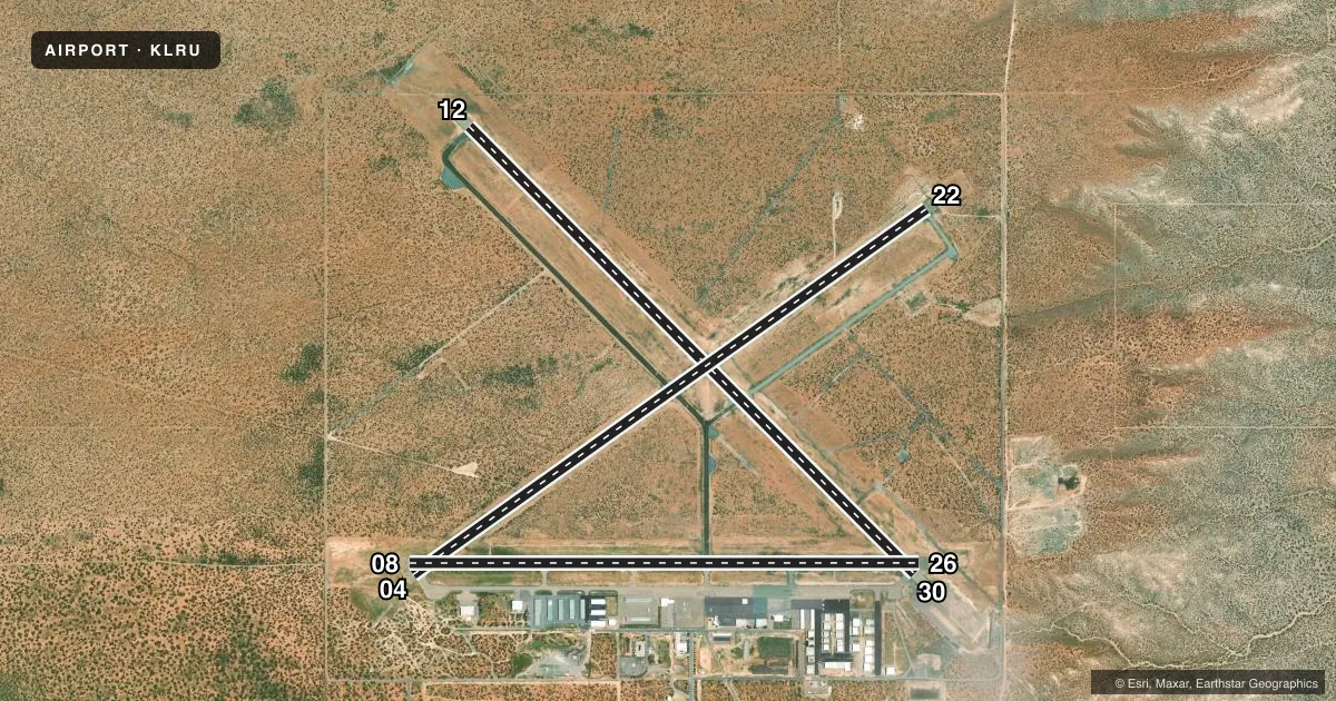
Runways & pattern
Full pagePattern entry · RWY 12
LEFT TRAFFIC| Runway | Heading (°M) | Length | Surface | Traffic |
|---|---|---|---|---|
| 12/30 | 127° / 307° | 7,506 ft | CONC | Standard L |
| 04/22 | 47° / 227° | 7,501 ft | ASPH | Standard L |
| 08/26 | 82° / 262° | 6,069 ft | ASPH | Standard L |
Runway end performance
| End | TORA | TODA | ASDA | LDA | VGSI | Approach lights | Obstruction |
|---|---|---|---|---|---|---|---|
| 12 | 7,506' | 7,506' | 7,506' | 7,506' | — | — | — |
| 30 | 7,506' | 7,506' | 7,500' | 7,500' | — | MALSR | — |
| 04 | 7,499' | 7,499' | 7,499' | 7,499' | — | — | — |
| 22 | 7,499' | 7,499' | 7,499' | 7,499' | VASI 4-box left(3°) | — | — |
| 08 | 6,069' | 6,069' | 6,050' | 6,050' | PAPI 4-box left(3°) | — | — |
| 26 | 6,069' | 6,069' | 6,069' | 6,069' | PAPI 4-box left(3°) | — | — |
Declared distances in feet. TORA = takeoff run available, TODA = takeoff distance, ASDA = accelerate-stop, LDA = landing distance.
Airport sketch
Runways drawn to scale from FAA survey coordinates, rendered over satellite imagery. Not for navigation.
Approaches & charts
ILS · 1
Services on the field
Fuel grades, oxygen, maintenance, ramp storage and lighting — as declared to the FAA by the airport operator.
Fuel & services
- Fuel
- 100LLA1+
- Oxygen (bottled)
- High pressure
- Oxygen (bulk)
- High pressure
- Airframe repair
- Major
- Power plant repair
- Major
- Other services
- AFRT,AMB,INSTR,RNTL
Ramp & ground
- Transient storage
- Tie-down
- Hangar
- Landing fee
- No fee published
- Customs
- Not available
- Lighting schedule
- SEE RMK
- Beacon schedule
- SS-SR
- Beacon
- White / Green (civil land)(WG)
- Wind indicator
- Lighted
- Segmented circle
- Yes
Fuel & FBOs
Cheapest 100LL and Jet A on the field and nearby. Always confirm with the FBO before taxi.
Airport notes
Surface conditions, obstructions, local procedures, lighting outages and other notes published with each FAA cycle.
General notes
- BIRDS ON & INVOF ARPT SEP-MAR. UAS TRNG ON ARPT.
- UAS TRNG & FOR CD CTC ALBUQUERQUE ARTCC AT 505-856-4861.
Lighting notes
- ACTVT MALSR RWY 30; MIRL RWY 04/22 & 8/26; HIRL RWY 12/30 - CTAF. REIL RWY 12 SS-SR. PAPI RWY 08, 26 & VASI RWY 22 ON CONSLY. MIRL RWY 08/26 PRESET LOW INTST; INCR INTST - CTAF.
Runway surface & condition
- 04/22PCR VALUE: 90/F/D/X/T
- 08/26PCR VALUE: 240/F/C/X/T
- 12/30PCR VALUE: 520/R/B/W/T
- 04/22ACR & ACFT OVER 30000 LBS NA.
- 12/30RWY 30 CALM WIND RWY.
Other notes
- 48 HR PPR FOR ACR ACFT WITH MORE THAN 30 PAX SEATS - 575-541-2471/2473.
- 04/22BLOCK CRACKING UP TO 3 IN WIDE CRACKS, RAVELING, AND WEATHERING.
VFR map & nearby airports
VFR sectional. Tap any ICAO chip to open that airport.
Key facts · KLRU
Answer card- ICAO
- KLRU
- Name
- LAS CRUCES INTL
- Location
- LAS CRUCES, NEW MEXICO
- Elevation
- 4,456.9 ft MSL
- Traffic pattern altitude
- 5,456.9 ft MSL (1,000 AGL)
- Control tower
- Non-towered (use CTAF)
- Total runways
- 3
- Longest runway
- 12/30 · 7,506 ft
- Published ILS approaches
- 1
- Published frequencies
- 2
- Magnetic variation
- 8°
- Current flight rules
- VFR
- Current wind
- 000° at 0 kt
- Favored runway now
- –
Las Cruces Intl is in Las Cruces, New Mexico. The field elevation is 4,456.9 ft MSL. It has three runways. The longest is runway 12/30 at 7,506 ft. There is no control tower. CTAF and UNICOM are both 122.7.
One ILS approach is published for runway 30. Runway 30 is also the calm wind runway. The pattern altitude is not published, so plan on the standard 1,000 ft AGL for light piston traffic unless the current FAA Chart Supplement says otherwise. That puts the traffic pattern around 5,457 ft MSL.
Francis Aviation is on the field. It carries 100LL and Jet A Prist. Southwest Aviation is also on the field. It carries 100LL and Jet A Prist. Frost Aviation Services is on the field too. It carries 100LL.
The lighting setup is worth a look before arrival. Runway 30 has medium intensity approach lights with runway alignment indicator lights. Runway 12/30 has high intensity runway lights. Runway 08/26 uses preset low intensity lights that can be increased on CTAF. Runway 22 has visual approach slope indicators that stay on continuously. Birds are reported on and near the airport from September through March. UAS training also takes place on the airport. The field sits at elevation in southern New Mexico, so density altitude can be a factor on warm days. Check performance before departure.