METAR & TAF KLCH
Current METAR
Observed 12:53Z
KLCH 271253Z 31004KT 10SM CLR 28/26 A3000 RMK AO2 SLP167 T02780256
- Wind
- 310° @ 4 kt
- Visibility
- 10 SM
- Temp / Dew
- 28°C / 26°C
- Altimeter
- 30.00 inHg
- Clouds
- CLR
- Density alt
- 1,479 ft
- Ceiling
- Unlimited
- Rules
- VFR
Airport info & contacts
Manager on record, flight service, ARTCC, attendance schedule and pattern altitude — published by the FAA and refreshed every 28 days.
Location
- From city
- 5 NM S
- VFR sectional
- HOUSTON
- ARTCC
- ZHU · HOUSTON
- NOTAM facility
- LCH (NOTAM-D)
Airport manager
- Name
- HEATH ALLEN
- Phone
- 337-477-6051
- Address
- PO DRAWER 5820, LAKE CHARLES LA 70607-5820
Flight service · Hours
- FSS DRI
- DE RIDDER1-800-WX-BRIEF
- Attendance
- 0500-2230
Frequencies
Tap any row to copy the frequency to your clipboard.
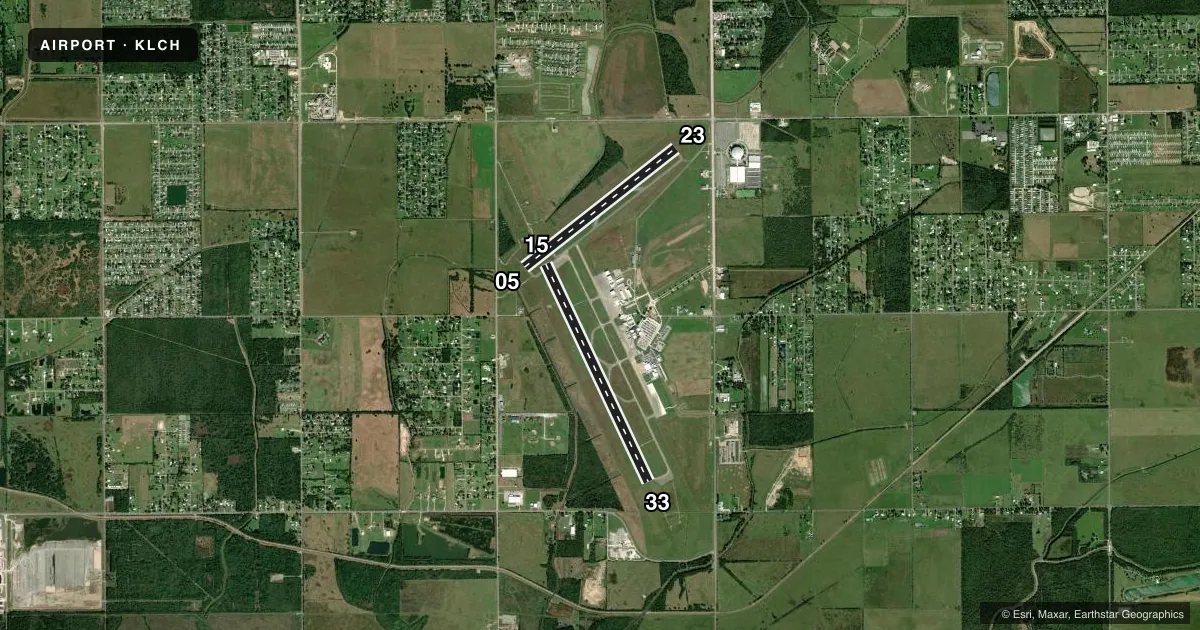
Runways & pattern
Full pagePattern entry · RWY 33
LEFT TRAFFIC| Runway | Heading (°M) | Length | Surface | Traffic |
|---|---|---|---|---|
| 15/33Favored | 152° / 332° | 6,500 ft | CONC | 15 R |
| 05/23 | 49° / 229° | 5,200 ft | ASPH | 23 R |
Runway end performance
| End | TORA | TODA | ASDA | LDA | VGSI | Approach lights | Obstruction |
|---|---|---|---|---|---|---|---|
| 15 | 6,500' | 6,500' | 6,500' | 6,500' | PAPI 4-box left(3°) | MALSR | 28', pole, 1412' from thr, 421' R of cntrln, slope 46 |
| 33 | 6,500' | 6,500' | 6,500' | 6,500' | PAPI 4-box right(3°) | MALSF | — |
| 05 | 5,200' | 5,200' | 5,200' | 5,200' | PAPI 4-box left(3°) | — | 65', tree, 1620' from thr, 455' R of cntrln, slope 21 |
| 23 | 5,200' | 5,200' | 5,200' | 5,200' | VASI 4-box left(3°) | — | — |
Declared distances in feet. TORA = takeoff run available, TODA = takeoff distance, ASDA = accelerate-stop, LDA = landing distance.
Airport sketch
Runways drawn to scale from FAA survey coordinates, rendered over satellite imagery. Not for navigation.
Approaches & charts
ILS · 1
Services on the field
Fuel grades, oxygen, maintenance, ramp storage and lighting — as declared to the FAA by the airport operator.
Fuel & services
- Fuel
- 100LLA1+
- Oxygen (bottled)
- Not available
- Oxygen (bulk)
- Not available
- Airframe repair
- Major
- Power plant repair
- Major
- Other services
- AFRT,AVNCS,CHTR,INSTR,RNTL
Ramp & ground
- Transient storage
- Tie-down
- Hangar
- Landing fee
- No fee published
- Customs
- Not available
- Lighting schedule
- SEE RMK
- Beacon schedule
- SS-SR
- Beacon
- White / Green (civil land)(WG)
- Wind indicator
- Lighted
- Segmented circle
- Yes
Fuel & FBOs
Cheapest 100LL and Jet A on the field and nearby. Always confirm with the FBO before taxi.
Airport notes
Surface conditions, obstructions, local procedures, lighting outages and other notes published with each FAA cycle.
General notes
- ATCT BLIND SPOT ON TWY J.
- BIRDS ON & INVOF ARPT.
- FOR CD IF UNA TO CTC ON FSS FREQ, CTC HOUSTON ARTCC AT 281-230-5622.
Lighting notes
- WHEN ATCT CLSD ACTVT MALSR RWY 15; MALSF RWY 33; HIRL RWY 15/33; MIRL RWY 05/23 - CTAF. PAPI RWY 33 OPR CONSLY.
Runway surface & condition
- 05/23PCR VALUE: 89/F/D/X/T
- 15/33PCR VALUE: 287/R/D/X/T
Other notes
- 15/33SOUTH 900 FT GRVD.
VFR map & nearby airports
VFR sectional. Tap any ICAO chip to open that airport.
Key facts · KLCH
Answer card- ICAO
- KLCH
- Name
- LAKE CHARLES RGNL
- Location
- LAKE CHARLES, LOUISIANA
- Elevation
- 14.5 ft MSL
- Traffic pattern altitude
- 1,014.5 ft MSL (1,000 AGL)
- Control tower
- Towered · 0600-2200
- Total runways
- 2
- Longest runway
- 15/33 · 6,500 ft
- Published ILS approaches
- 1
- Published frequencies
- 17
- Magnetic variation
- 3°
- Current flight rules
- VFR
- Current wind
- 310° at 4 kt
- Favored runway now
- RWY 33
Lake Charles Rgnl sits in Lake Charles, Louisiana. Field elevation is 14.5 ft MSL. The airport has 2 runways. The longest is 6,500 ft on runway 15/33. The tower is open 0600-2200. One ILS is published for runway 15.
Pattern altitude is not published. Use 1,000 ft AGL for light piston operations unless ATC or the current Chart Supplement says otherwise. That puts the standard pattern at 1,014.5 ft MSL based on the field elevation. Freeman Jet Center - Lake Charles is on the field. It carries AVGAS 100LL, JET A and JET A PRIST. Call them at (337) 478-7722 for current services.
The airport sits in a low-elevation coastal area. Expect busy traffic and stay sharp for birds in the airport area and nearby. There is also a blind spot on taxiway J from the tower. When the tower is closed, use CTAF 120.7 and follow the published lighting setup for the runways. If you need clearance delivery and cannot reach Flight Service, Houston ARTCC is listed as a backup contact. Check the current Chart Supplement for any noise or curfew restrictions before flying into the field.