METAR & TAF KLBF
Current METAR
Observed 16:53Z
KLBF 271653Z AUTO 07013G21KT 10SM CLR 34/24 A2991 RMK AO2 SLP090 T03390244
- Wind
- 070° @ 13G21 kt
- Visibility
- 10 SM
- Temp / Dew
- 34°C / 24°C
- Altimeter
- 29.91 inHg
- Clouds
- CLR
- Density alt
- 5,736 ft
- Ceiling
- Unlimited
- Rules
- VFR
Airport info & contacts
Manager on record, flight service, ARTCC, attendance schedule and pattern altitude — published by the FAA and refreshed every 28 days.
Location
- From city
- 3 NM E
- VFR sectional
- OMAHA
- ARTCC
- ZDV · DENVER
- NOTAM facility
- LBF (NOTAM-D)
Airport manager
- Name
- MR. JUSTIN GOSNELL
- Phone
- 308-532-1900
- Address
- 5400 E LEE BIRD DR, NORTH PLATTE NE 69101
Flight service · Hours
- FSS OLU
- COLUMBUS1-800-WX-BRIEF
- Attendance
- 0600-2300
Frequencies
Tap any row to copy the frequency to your clipboard.
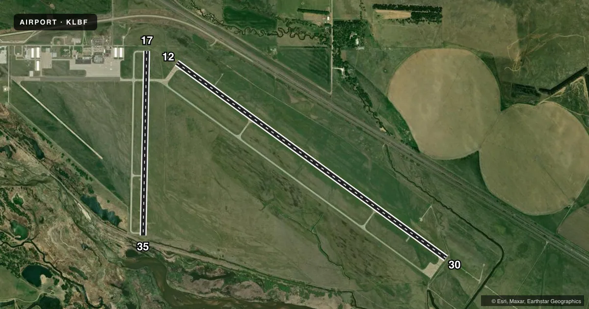
Runways & pattern
Full pagePattern entry · RWY 12
LEFT TRAFFIC| Runway | Heading (°M) | Length | Surface | Traffic |
|---|---|---|---|---|
| 12/30Favored | 120° / 300° | 8,001 ft | CONC | Standard L |
| 17/35 | 175° / 355° | 4,436 ft | CONC | Standard L |
Runway end performance
| End | TORA | TODA | ASDA | LDA | VGSI | Approach lights | Obstruction |
|---|---|---|---|---|---|---|---|
| 12 | 8,001' | 8,001' | 8,001' | 8,001' | PAPI 4-box left(3°) | — | — |
| 30 | 8,001' | 8,001' | 8,001' | 8,001' | PAPI 4-box left(3°) | MALSR | — |
| 17 | 4,436' | 4,436' | 4,135' | 4,135' | — | — | 21', road, 850' from thr, 0' R of cntrln, slope 30 |
| 35 | 4,436' | 4,436' | 4,436' | 4,135' | VASI 4-box left(3°) | — | 27', tree, 675' from thr, 150' R of cntrln, slope 17 |
Declared distances in feet. TORA = takeoff run available, TODA = takeoff distance, ASDA = accelerate-stop, LDA = landing distance.
Airport sketch
Runways drawn to scale from FAA survey coordinates, rendered over satellite imagery. Not for navigation.
Approaches & charts
ILS · 1
Services on the field
Fuel grades, oxygen, maintenance, ramp storage and lighting — as declared to the FAA by the airport operator.
Fuel & services
- Fuel
- 100LLA
- Oxygen (bottled)
- HIGH/LOW
- Oxygen (bulk)
- Low pressure
- Airframe repair
- Major
- Power plant repair
- Major
- Other services
- AFRT,CHTR,INSTR,RNTL
Ramp & ground
- Transient storage
- Tie-down
- Hangar
- Landing fee
- No fee published
- Customs
- Not available
- Lighting schedule
- SEE RMK
- Beacon schedule
- SS-SR
- Beacon
- White / Green (civil land)(WG)
- Wind indicator
- Lighted
- Segmented circle
- Yes
Fuel & FBOs
Cheapest 100LL and Jet A on the field and nearby. Always confirm with the FBO before taxi.
Airport notes
Surface conditions, obstructions, local procedures, lighting outages and other notes published with each FAA cycle.
General notes
- WATERFOWL ON & INVOF ARPT.
- FOR CD CTC DENVER ARTCC ON FREQ. IF UNA, CTC FSS ON FREQ VIA RCO. IF UNA, CTC DENVER ARTCC AT 303-651-4257.
Lighting notes
- ACTVT HIRL RWY 12/30; MIRL RWY 17/35; PAPI RWY 12 & 30; VASI RWY 35; MALSR RWY 30 & REIL RWY 35 - CTAF.
Runway surface & condition
- 12/30PCR VALUE: 390/R/C/W/T
- 17/35PCR VALUE: 230/R/C/W/T
Approach & departure obstructions
- 35RWY 35 APCH RATIO 36:1 TO DSPLCD THLD.
Other notes
- PPR 24 HRS FOR UNSKED ACR OPNS WITH MORE THAN 30 PSGR SEATS CALL AMGR 308-530-6948, ARFF INDEX B EQUIP PRVD.
- ALL CAT D ACFT (WITH SPDS OF 141-166 KTS) OPERATING ON RWY 12/30 MUST MNTN A TPA OF 1500 FT WHEN IN THE TFC PAT.
- MANAGERAFT HRS EMERG, CALL OPNS SUPVR 308-530-6948.
VFR map & nearby airports
VFR sectional. Tap any ICAO chip to open that airport.
Key facts · KLBF
Answer card- ICAO
- KLBF
- Name
- NORTH PLATTE RGNL/LEE BIRD FLD
- Location
- NORTH PLATTE, NEBRASKA
- Elevation
- 2,777 ft MSL
- Traffic pattern altitude
- 3,777 ft MSL (1,000 AGL)
- Control tower
- Non-towered (use CTAF)
- Total runways
- 2
- Longest runway
- 12/30 · 8,001 ft
- Published ILS approaches
- 1
- Published frequencies
- 2
- Magnetic variation
- 6°
- Current flight rules
- VFR
- Current wind
- 070° at 13 kt
- Favored runway now
- RWY 12
North Platte Rgnl/Lee Bird Fld (KLBF) sits in North Platte, Nebraska. The field elevation is 2,777 ft MSL. It has two concrete runways. The longest is runway 12/30 at 8,001 ft. The airport is non-towered. CTAF and UNICOM are both 123.0. One ILS is published. It serves runway 30.
Pattern altitude is not published. Use 1,000 ft AGL for light piston traffic unless local procedures or ATC instructions say otherwise. Trego-Dugan Aviation is on the field. It carries 100LL and Jet A Prist. Clearance delivery goes through Denver ARTCC. If that is not available, use Flight Service Station through the remote communications outlet. Waterfowl are reported on and near the airport. Expect bird activity on arrival and departure.
Runway 12/30 has high intensity lighting, PAPI on both ends and MALSR on runway 30. Runway 17/35 has medium intensity lighting, VASI on runway 35 and REIL on runway 35. Runway 35 also has a published approach slope note to the displaced threshold. If you are planning a larger aircraft or an unscheduled air carrier flight, check the current Chart Supplement and call the airport manager. The field also has a note for category D aircraft on runway 12/30. Those aircraft need a 1,500 ft pattern altitude when in the pattern.