METAR & TAF KJQF
Current METAR
Observed 11:50Z
KJQF 271150Z 00000KT 4SM BR FEW013 23/23 A2992
- Wind
- 000° @ 0 kt
- Visibility
- 4 SM
- Temp / Dew
- 23°C / 23°C
- Altimeter
- 29.92 inHg
- Clouds
- FEW
- Density alt
- 1,833 ft
- Ceiling
- Unlimited
- Rules
- MVFR
Airport info & contacts
Manager on record, flight service, ARTCC, attendance schedule and pattern altitude — published by the FAA and refreshed every 28 days.
Location
- From city
- 7 NM W
- VFR sectional
- CHARLOTTE
- ARTCC
- ZTL · ATLANTA
- NOTAM facility
- JQF (NOTAM-D)
Airport manager
- Name
- ERIC PRATT
- Phone
- 704-920-5912
- Address
- 9000 AVIATION BLVD, CONCORD NC 28027
Flight service · Hours
- FSS RDU
- RALEIGH1-800-WX-BRIEF
- Attendance
- ALL
Frequencies
Tap any row to copy the frequency to your clipboard.
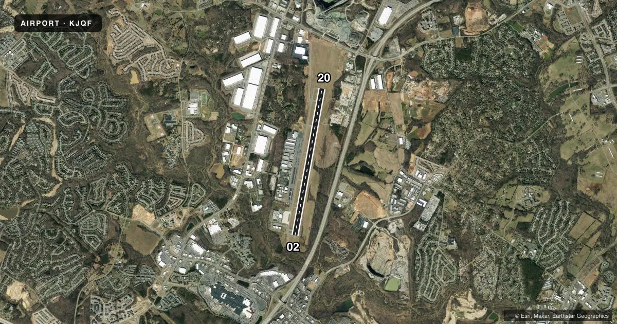
Runways & pattern
Full pagePattern entry · RWY 02
LEFT TRAFFICRunway end performance
| End | TORA | TODA | ASDA | LDA | VGSI | Approach lights | Obstruction |
|---|---|---|---|---|---|---|---|
| 02 | 7,400' | 7,400' | 7,400' | 7,400' | PAPI 4-box left(3.5°) | — | 13', trees, 281' from thr, 248' R of cntrln, slope 6 |
| 20 | 7,400' | 7,400' | 7,000' | 6,350' | PAPI 4-box left(3°) | MALSR | 127', trees, 3200' from thr, 500' R of cntrln, slope 23 |
Declared distances in feet. TORA = takeoff run available, TODA = takeoff distance, ASDA = accelerate-stop, LDA = landing distance.
Airport sketch
Runways drawn to scale from FAA survey coordinates, rendered over satellite imagery. Not for navigation.
Approaches & charts
ILS · 1
Services on the field
Fuel grades, oxygen, maintenance, ramp storage and lighting — as declared to the FAA by the airport operator.
Fuel & services
- Fuel
- 100LLAA+
- Oxygen (bottled)
- High pressure
- Airframe repair
- Major
- Power plant repair
- Major
- Other services
- AMB,AVNCS,CHTR,INSTR,RNTL,SALES
Ramp & ground
- Transient storage
- Tie-down
- Hangar
- Lighting schedule
- SEE RMK
- Beacon schedule
- SS-SR
- Beacon
- White / Green (civil land)(WG)
- Wind indicator
- Lighted
- Segmented circle
- Yes
Fuel & FBOs
Cheapest 100LL and Jet A on the field and nearby. Always confirm with the FBO before taxi.
Airport notes
Surface conditions, obstructions, local procedures, lighting outages and other notes published with each FAA cycle.
General notes
- FOR CD WHEN ATCT IS CLSD CTC CLT APCH AT 704-359-0241.
Lighting notes
- WHEN ATCT CLSD; TDZL RWY 20; HIRL RWY 02/20 & REIL RWY 02 PRESET LOW INTST. ACTVT MALSR RWY 20; REIL RWY 02; TDZL RWY 20; HIRL RWY 02/20 - CTAF. PAPI RWY 02 & 20 OPER CONSLY.
Runway surface & condition
- 02/20PCR VALUE: 450/F/D/X/T
Other notes
- 02/20GROOVED FULL LENGTH ASPHALT.
VFR map & nearby airports
VFR sectional. Tap any ICAO chip to open that airport.
Key facts · KJQF
Answer card- ICAO
- KJQF
- Name
- CONCORD-PADGETT RGNL
- Location
- CONCORD, NORTH CAROLINA
- Elevation
- 704.2 ft MSL
- Traffic pattern altitude
- 1,704.2 ft MSL (1,000 AGL)
- Control tower
- Towered · 0700-2300
- Total runways
- 1
- Longest runway
- 02/20 · 7,402 ft
- Published ILS approaches
- 1
- Published frequencies
- 9
- Magnetic variation
- 6°
- Current flight rules
- MVFR
- Current wind
- 000° at 0 kt
- Favored runway now
- –
Concord-Padgett Regional Airport sits in Concord, North Carolina. Field elevation is 704.2 ft MSL. The airport has one runway, 02/20 and it is 7,402 ft long. The tower is open daily from 0700 to 2300. One ILS approach is published for runway 20.
The pattern altitude is not published in the facts. Use standard 1,000 ft AGL for light piston traffic unless the current Chart Supplement says otherwise. The field has a grooved full-length asphalt runway. The pavement classification number for runway 02/20 is 450/F/D/X/T.
When the tower is closed, runway lighting is set to low intensity. The runway 20 approach lights, runway end identifier lights, touchdown zone lighting and high intensity runway lights can be activated by CTAF. The PAPI on runways 02 and 20 operates continuously. For clearance delivery after tower hours, contact Charlotte Approach.
The on-field FBO is Concord-Padgett Regional Airport. It carries 100LL, Jet A and Jet A Prist. If you are planning a first visit, pay attention to the tower hours and the lighting setup after dark. This is a busy controlled field near Charlotte. Get the current procedures from the FAA Chart Supplement before you go.