METAR & TAF KJLN
Current METAR
Observed 21:53Z
KJLN 272153Z 19012KT 10SM CLR 38/19 A2984 RMK AO2 SLP089 T03780189
- Wind
- 190° @ 12 kt
- Visibility
- 10 SM
- Temp / Dew
- 38°C / 19°C
- Altimeter
- 29.84 inHg
- Clouds
- CLR
- Density alt
- 4,072 ft
- Ceiling
- Unlimited
- Rules
- VFR
Airport info & contacts
Manager on record, flight service, ARTCC, attendance schedule and pattern altitude — published by the FAA and refreshed every 28 days.
Location
- From city
- 4 NM N
- VFR sectional
- KANSAS CITY
- ARTCC
- ZKC · KANSAS CITY
- NOTAM facility
- JLN (NOTAM-D)
Airport manager
- Name
- MS. ALLISON ZAHNER
- Phone
- 417-623-0262
- Address
- 7331 STATE HWY 43, JOPLIN MO 64801
Flight service · Hours
- FSS COU
- COLUMBIA1-800-WX-BRIEF
- Attendance
- 0500-0000
Frequencies
Tap any row to copy the frequency to your clipboard.
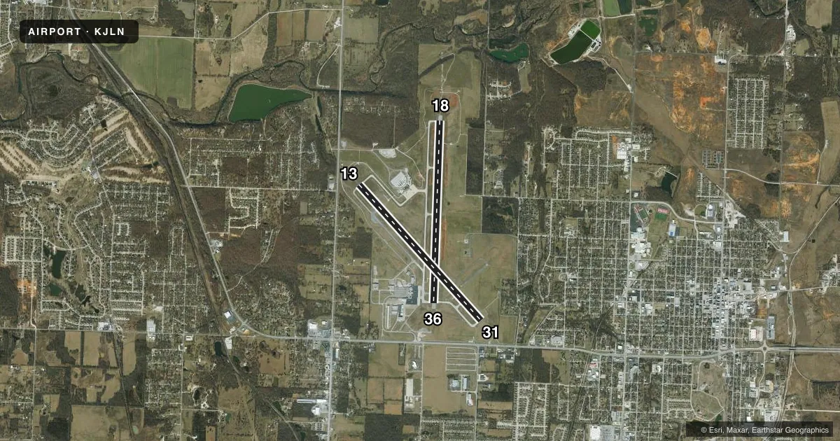
Runways & pattern
Full pagePattern entry · RWY 18
LEFT TRAFFIC| Runway | Heading (°M) | Length | Surface | Traffic |
|---|---|---|---|---|
| 18/36Favored | 178° / 358° | 6,502 ft | CONC | Standard L |
| 13/31 | 134° / 314° | 6,501 ft | ASPH | Standard L |
Runway end performance
| End | TORA | TODA | ASDA | LDA | VGSI | Approach lights | Obstruction |
|---|---|---|---|---|---|---|---|
| 18 | 6,499' | 6,499' | 6,499' | 6,499' | PAPI 4-box left(3°) | MALSR | 15', pole, 675' from thr, 400' R of cntrln, slope 31 |
| 36 | 6,499' | 6,499' | 6,499' | 6,499' | PAPI 4-box left(3°) | — | — |
| 13 | 6,500' | 6,500' | 6,201' | 5,813' | — | MALSF | 36', tree, 825' from thr, 490' R of cntrln, slope 17 |
| 31 | 6,500' | 6,500' | 6,112' | 5,813' | PAPI 4-box left(3°) | ODALS | 47', tree, 1200' from thr, 300' R of cntrln, slope 21 |
Declared distances in feet. TORA = takeoff run available, TODA = takeoff distance, ASDA = accelerate-stop, LDA = landing distance.
Airport sketch
Runways drawn to scale from FAA survey coordinates, rendered over satellite imagery. Not for navigation.
Approaches & charts
ILS · 2
Services on the field
Fuel grades, oxygen, maintenance, ramp storage and lighting — as declared to the FAA by the airport operator.
Fuel & services
- Fuel
- 100LLA
- Oxygen (bottled)
- Not available
- Oxygen (bulk)
- Low pressure
- Airframe repair
- Major
- Power plant repair
- Major
- Other services
- AFRT,AMB,CHTR,INSTR,RNTL,SALES
Ramp & ground
- Transient storage
- Tie-down
- Hangar
- Landing fee
- No fee published
- Customs
- Not available
- Lighting schedule
- SEE RMK
- Beacon schedule
- SS-SR
- Beacon
- White / Green (civil land)(WG)
- Wind indicator
- Lighted
- Segmented circle
- No
Fuel & FBOs
Cheapest 100LL and Jet A on the field and nearby. Always confirm with the FBO before taxi.
Airport notes
Surface conditions, obstructions, local procedures, lighting outages and other notes published with each FAA cycle.
General notes
- BIRDS ON & INVOF ARPT SPRING & FALL.
- PPR 48 HRS FOR ACFT CARRYING HAZARDOUS OR EXPLOSIVE CARGO.
- FOR CD IF UNA TO CTC ON FSS FREQ, CTC KANSAS CITY ARTCC AT 913-254-8508.
Lighting notes
- WHEN ATCT CLSD ACTVT MALSF RWY 13; ODALS RWY 31; PAPI RWY 18; HIRL RWY 13/31 - CTAF. MALSR RWY 18; PAPI RWY 31; HIRL RWY 18/36 - OPR DUSK-DAWN.
Runway surface & condition
- 13/31PCR VALUE: 630/F/D/X/T
- 18/36PCR VALUE: 590/R/D/W/T
Approach & departure obstructions
- 13APCH RATIO FROM DSPLCD THR 33:1
- 31APCH RATIO FROM DSPLCD THR 32:1
Other notes
- PPR 48 HRS FOR UNSKED ACR OPNS WITH MORE THAN 30 PSGR SEATS CALL AMGR 417-623-0262.
VFR map & nearby airports
VFR sectional. Tap any ICAO chip to open that airport.
Key facts · KJLN
Answer card- ICAO
- KJLN
- Name
- JOPLIN RGNL
- Location
- JOPLIN, MISSOURI
- Elevation
- 977.9 ft MSL
- Traffic pattern altitude
- 1,977.9 ft MSL (1,000 AGL)
- Control tower
- Towered · 0600-2100
- Total runways
- 2
- Longest runway
- 18/36 · 6,502 ft
- Published ILS approaches
- 2
- Published frequencies
- 5
- Magnetic variation
- 4°
- Current flight rules
- VFR
- Current wind
- 190° at 12 kt
- Favored runway now
- RWY 18
Joplin Regional Airport sits in Joplin, Missouri. Field elevation is 977.9 ft MSL. The airport has two runways. The longest is runway 18/36 at 6,502 ft. Runway 13/31 is 6,501 ft. The tower is open 0600-2100. ILS approaches are published for runway 13 and runway 18.
Pattern altitude is not published. Use 1,000 ft AGL for light piston traffic unless ATC or local procedures tell you otherwise. Mizzou Aviation is on the field. It carries 100LL and Jet A Prist. Call them at (417) 623-1331 for current service details.
A few remarks matter here. Birds are reported on and near the airport in spring and fall. Runway 13/31 and 18/36 both have published pavement limits, so check your aircraft weight and runway suitability before you go. When the tower is closed, the lighting setup changes by runway. If you are arriving after hours, verify the current lighting and approach setup with the current FAA Chart Supplement or the FBO directly by phone.
For the first-time pilot, the big things are the towered environment, the two long paved runways and the published ILS options. If you need clearance delivery and cannot reach flight service, contact Kansas City Center at 913-254-8508. Hazardous cargo and some large unscheduled passenger operations need prior permission 48 hours ahead.