METAR & TAF KJAN
Current METAR
Observed 14:54Z
KJAN 271454Z 30006KT 10SM CLR 32/24 A3000 RMK AO2 SLP152 T03220244 50004
- Wind
- 300° @ 6 kt
- Visibility
- 10 SM
- Temp / Dew
- 32°C / 24°C
- Altimeter
- 30.00 inHg
- Clouds
- CLR
- Density alt
- 2,370 ft
- Ceiling
- Unlimited
- Rules
- VFR
Airport info & contacts
Manager on record, flight service, ARTCC, attendance schedule and pattern altitude — published by the FAA and refreshed every 28 days.
Location
- From city
- 5 NM E
- VFR sectional
- MEMPHIS
- ARTCC
- ZME · MEMPHIS
- NOTAM facility
- JAN (NOTAM-D)
Airport manager
- Name
- ROSA BECKETT
- Phone
- 601-939-5631
- Address
- 100 INTERNATIONAL DRIVE, SUITE 300, JACKSON MS 39208-8109
Flight service · Hours
- FSS GWO
- GREENWOOD1-800-WX-BRIEF
- Attendance
- ALL
Frequencies
Tap any row to copy the frequency to your clipboard.
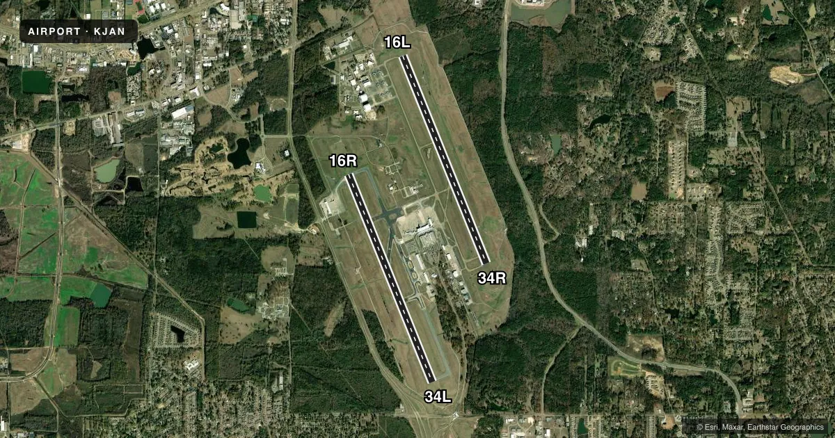
Runways & pattern
Full pagePattern entry · RWY 34R
LEFT TRAFFIC| Runway | Heading (°M) | Length | Surface | Traffic |
|---|---|---|---|---|
| 16L/34RFavored | 157° / 337° | 8,500 ft | ASPH | Standard L |
| 16R/34L | 157° / 337° | 8,500 ft | ASPH | Standard L |
Runway end performance
| End | TORA | TODA | ASDA | LDA | VGSI | Approach lights | Obstruction |
|---|---|---|---|---|---|---|---|
| 16L | — | — | — | — | PAPI 4-box left(3°) | ALSF2 | 57', trees, 2500' from thr, 35' R of cntrln, slope 40 |
| 34R | — | — | — | — | PAPI 4-box right(3°) | — | 51', trees, 2750' from thr, 650' R of cntrln, slope 50 |
| 16R | — | — | — | — | PAPI 4-box left(3°) | — | — |
| 34L | — | — | — | — | — | MALSR | 78', trees, 4100' from thr, 700' R of cntrln, slope 50 |
Declared distances in feet. TORA = takeoff run available, TODA = takeoff distance, ASDA = accelerate-stop, LDA = landing distance.
Airport sketch
Runways drawn to scale from FAA survey coordinates, rendered over satellite imagery. Not for navigation.
Approaches & charts
ILS · 2
Services on the field
Fuel grades, oxygen, maintenance, ramp storage and lighting — as declared to the FAA by the airport operator.
Fuel & services
- Fuel
- 100LLAA+
- Oxygen (bottled)
- HIGH/LOW
- Oxygen (bulk)
- HIGH/LOW
- Airframe repair
- Major
- Power plant repair
- Major
- Other services
- AMB,AVNCS,CHTR
Ramp & ground
- Transient storage
- Tie-down
- Hangar
- Customs
- Not available
- Lighting schedule
- SEE RMK
- Beacon schedule
- SS-SR
- Beacon
- White / Green (civil land)(WG)
- Wind indicator
- Lighted
- Segmented circle
- Yes
Fuel & FBOs
Cheapest 100LL and Jet A on the field and nearby. Always confirm with the FBO before taxi.
Airport notes
Surface conditions, obstructions, local procedures, lighting outages and other notes published with each FAA cycle.
General notes
- BRG STRENGTH RWY 16L/34R & 16R/34L: ST175.
- JASU: 8(A/M32A-86D) 3(MC-1A).
- MILITARY: ANG: OFFL BUS. ALL TRAN ACFT 48HR PPR. LTD PRK USE. CTC AFLD MGMT. TRAN ACFT USE FBO FOR SVC. AFLD MGMT OPR 1300-0230Z++ WKD, DSN 828-8372, C601-405-8372. COMD POST OPR 1200-0630Z++ WKD, DSN 828-8350, C601-405-8350. AFLD MGMT & COMD POST HAVE LTD COMSEC STORAGE. TOP SECRET STORAGE UNAVBL.
- BE ALERT WHEN XNG AER 16R.
- MIL ACFT USE TWY C7 TO ACES THE FBO APRON UNLESS OTRW DRCTD BY ATC.
- HOLD AREA 1 & 2 CMSND ON TERM APRON BTN TWY B3 & TWY B5.
- FOR CD CTC MEMPHIS ARTCC AT 901-368-8453/8449.
- CAUTION - BASH PHASE II PERIOD JUL-OCT. CTC AFLD MGMT OR COMD POST FOR CURRENT BIRD WATCH COND.
- MILITARY: ANG: BASH PHASE II IN EFCT 1 JUL-31 OCT. CTC TWR, COMMAND POST OR AFM FOR BIRD HAZ. WILDLIFE MOST ACTV +/- 1 HR OF SS AND SR.
- MILITARY: ANG: ARFF STS CRITICAL LEVEL OF SVC (CLS) FOR MIL ACFT CAT 8.
Lighting notes
- WHEN TWR CLSD ACTVT MALSR RWY 34L; REIL RWY 16R & 34R; HIRL RWY 16L/34R & 16R/34L - CTAF. RWY 16L ALSF-2 PRESET ON MED INTST EXC SFL NOT AVBL.
Runway surface & condition
- 16L/34RWT BRG CPTY FOR RWYS 16L/34R & 16R/34L ARE TRT585 TO ACCOMMODATE C-17 ACFT.
- 16L/34RPCR VALUE: 605/F/C/X/T
- 16R/34LPCR VALUE: 816/F/D/X/T
Other notes
- LDG FEE FOR NON-COML ACFT OVR 25500 LBS; FEE WAIVED FOR LRGR NON-SKED ACFT WITH SUF FUEL PURCHASE.
VFR map & nearby airports
VFR sectional. Tap any ICAO chip to open that airport.
Key facts · KJAN
Answer card- ICAO
- KJAN
- Name
- JACKSON-MEDGAR WILEY EVERS INTL
- Location
- JACKSON, MISSISSIPPI
- Elevation
- 346.4 ft MSL
- Traffic pattern altitude
- 1,346.4 ft MSL (1,000 AGL)
- Control tower
- Towered · 1200-0500Z++
- Total runways
- 2
- Longest runway
- 16L/34R · 8,500 ft
- Published ILS approaches
- 2
- Published frequencies
- 17
- Magnetic variation
- 1°
- Current flight rules
- VFR
- Current wind
- 300° at 6 kt
- Favored runway now
- RWY 34R
Jackson-Medgar Wiley Evers Intl is in Jackson, Mississippi. Field elevation is 346.4 ft MSL. The airport has two asphalt runways. Both are 8,500 ft long, so the field has plenty of runway for most GA and turbine arrivals. The tower is open 1200-0500Z++. Pattern altitude is not published in the facts, so verify the current traffic pattern in the FAA Chart Supplement before you go. Two ILS approaches are published. They serve runways 16L and 34L.
Atlantic Aviation is the on-field FBO. It carries 100LL and Jet A. This is a busy controlled field with Class C service on the published approach frequency. Check the current FAA Chart Supplement for any local noise or curfew restrictions before flying in. The remarks also show military operating limits. Transient aircraft need 48-hour prior permission. Limited parking is noted. If you are arriving after the tower closes, lighting is activated on CTAF. Runway 34L uses the MALSR. Runway 16R and 34R use REIL. Runways 16L/34R and 16R/34L have HIRL. The field sits in a flat metro area. Plan for ATC coordination, runway selection and the military procedures in the remarks.