METAR & TAF KIDA
Current METAR
Observed 13:36Z
KIDA 271336Z 17003KT 2 1/2SM HZ OVC120 23/06 A3010 RMK AO2 T02280061
- Wind
- 170° @ 3 kt
- Visibility
- 0.5 SM
- Temp / Dew
- 23°C / 6°C
- Altimeter
- 30.10 inHg
- Clouds
- OVC
- Density alt
- 6,619 ft
- Ceiling
- 12,000 ft AGL
- Rules
- LIFR
Airport info & contacts
Manager on record, flight service, ARTCC, attendance schedule and pattern altitude — published by the FAA and refreshed every 28 days.
Location
- From city
- 2 NM NW
- VFR sectional
- SALT LAKE CITY
- ARTCC
- ZLC · SALT LAKE CITY
- NOTAM facility
- IDA (NOTAM-D)
Airport manager
- Name
- IAN TURNER
- Phone
- (208) 612-8224
- Address
- 2140 N SKYLINE, IDAHO FALLS ID 83402
Flight service · Hours
- FSS BOI
- BOISE1-800-WX-BRIEF
- Attendance
- 0530-2130
Frequencies
Tap any row to copy the frequency to your clipboard.
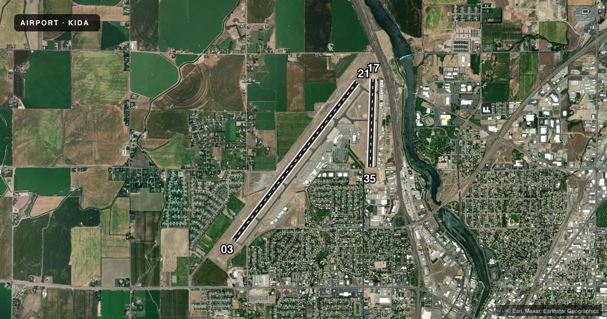
Runways & pattern
Full pagePattern entry · RWY 17
LEFT TRAFFIC| Runway | Heading (°M) | Length | Surface | Traffic |
|---|---|---|---|---|
| 03/21 | 26° / 206° | 9,002 ft | ASPH | Standard L |
| 17/35Favored | 170° / 350° | 3,964 ft | ASPH | Standard L |
Runway end performance
| End | TORA | TODA | ASDA | LDA | VGSI | Approach lights | Obstruction |
|---|---|---|---|---|---|---|---|
| 03 | 9,002' | 9,002' | 9,002' | 9,002' | PAPI 4-box left(3°) | — | — |
| 21 | 9,002' | 9,002' | 9,002' | 9,002' | PAPI 4-box left(3°) | MALSR | — |
| 17 | — | — | — | — | PAPI 2-box left(3°) | — | — |
| 35 | — | — | — | — | PAPI 4-box left(3.5°) | — | 23', ant, 700' from thr, 80' R of cntrln, slope 21 |
Declared distances in feet. TORA = takeoff run available, TODA = takeoff distance, ASDA = accelerate-stop, LDA = landing distance.
Airport sketch
Runways drawn to scale from FAA survey coordinates, rendered over satellite imagery. Not for navigation.
Approaches & charts
ILS · 1
Services on the field
Fuel grades, oxygen, maintenance, ramp storage and lighting — as declared to the FAA by the airport operator.
Fuel & services
- Fuel
- 100LLA1
- Oxygen (bottled)
- HIGH/LOW
- Oxygen (bulk)
- HIGH/LOW
- Airframe repair
- Major
- Power plant repair
- Major
- Other services
- AFRT,AVNCS,CARGO,CHTR,INSTR,RNTL,SALES
Ramp & ground
- Transient storage
- Tie-down
- Hangar
- Landing fee
- No fee published
- Customs
- Not available
- Lighting schedule
- SEE RMK
- Beacon schedule
- SS-SR
- Beacon
- White / Green (civil land)(WG)
- Wind indicator
- Lighted
- Segmented circle
- Yes
Fuel & FBOs
Cheapest 100LL and Jet A on the field and nearby. Always confirm with the FBO before taxi.
Airport notes
Surface conditions, obstructions, local procedures, lighting outages and other notes published with each FAA cycle.
General notes
- FLOCKS OF BIRDS & WATERFOWL ON & INVOF ARPT ALL YEAR.
- EXTSV AGRICULTURAL OPNS INVOF OF ARPT.
- ACFT OPS BE ALERT FOR POSSIBLE INCURSIONS; NO LINE OF SIGHT BTN RWYS.
- SFC CONDITIONS UNMONITORED 2300-0530.
- RWY 21 AND RWY 17 APCH ENDS IN CLOSE PROXIMITY. WRONG RWY DEP/ARR RISK. CHK RWY ALNMT. INTERSECTING FLT PATHS FOR RWYS 21 & 17, AND RWYS 03 & 35.
- SELF SVC FUEL EAST OF TWY BRAVO AVBL 24 HRS.
- ALL COMMERCIAL ACFT ADVISE PRIOR TO PUSHBACK.
- IDA SVC GND COM OUTLET CMSND KEY FREQ 121.725: 2 TIMES FUEL DLVY; 4 TIMES SLC ARTCC; 6 TIMES BOI FSS; 8 TIMES 911 DISPATCH SVC WHEN TWR CLSD.
- FQT VEHICLE TFC ON EAST RAMP ADJ TO TWY B.
- FOR CD IF UNA TO CTC ON FSS FREQ, CTC SALT LAKE ARTCC AT 801-320-2568.
Lighting notes
- WHEN ATCT CLSD, ACTVT MALSR RWY 21; REIL RWY 03; PAPI RWY 03; HIRL RWY 03/21 - CTAF. PAPI 17 & 35 U/S EXC WHEN ATCT AVBL.
Runway surface & condition
- 03/21PCR VALUE: 700/F/B/X/T
- 17/35PCR VALUE: 160/F/D/X/T
- 17/35CLSD NIGHTLY 2000-0700.
Other notes
- 24 HR PPR FOR UNSKED ACR OPNS WITH MORE THAN 30 PAX SEATS CALL AMGR 208-612-8224.
- TPA 1500 AGL (MULTI-ENG/TURBOJET ACFT), 1000 AGL (SGL ENG ACFT), 500 AGL (ROTORCRAFT).
- 1ON CALL 24 HRS PHONE 208-390-8746 OR 208-390-3624.
- MANAGERAIRPORT DIRECTOR
VFR map & nearby airports
VFR sectional. Tap any ICAO chip to open that airport.
Key facts · KIDA
Answer card- ICAO
- KIDA
- Name
- IDAHO FALLS RGNL
- Location
- IDAHO FALLS, IDAHO
- Elevation
- 4,743.7 ft MSL
- Traffic pattern altitude
- 5,743.7 ft MSL (1,000 AGL)
- Control tower
- Towered · 0700-2000
- Total runways
- 2
- Longest runway
- 03/21 · 9,002 ft
- Published ILS approaches
- 1
- Published frequencies
- 8
- Magnetic variation
- 12°
- Current flight rules
- LIFR
- Current wind
- 170° at 3 kt
- Favored runway now
- RWY 17
Idaho Falls Rgnl sits in Idaho Falls, Idaho. The field elevation is 4,743.7 ft MSL. It has two asphalt runways. The longest is runway 03/21 at 9,002 ft. The airport is towered. Tower hours are 0700 to 2000. One ILS approach is published for runway 21.
Pattern altitude is not published in the facts. Use the standard 1,000 ft AGL for light piston traffic unless the current Chart Supplement says otherwise. For this field, that puts the light piston pattern near 5,744 ft MSL. The airport sits in a busy agricultural area. Birds and waterfowl are reported on and near the airport year-round. That matters on departure and in the pattern.
Aero Mark is on the field. It carries 100LL, Jet A and Jet A Prist. Self-service fuel east of taxiway Bravo is available 24 hours. Runway lighting has some tower-closed procedures. Use CTAF for the published lighting activation steps when the tower is closed. Be careful with runway alignment here. Runways 21 and 17 have close approach ends. Runways 03 and 35 also have intersecting flight paths. Check the runway before you turn final or line up. Commercial crews must advise before pushback.