METAR & TAF KHUT
Current METAR
Observed 18:52Z
KHUT 271852Z 18016G24KT 10SM CLR 41/15 A2982 RMK AO2 PK WND 19026/1835 SLP066 T04060150
- Wind
- 180° @ 16G24 kt
- Visibility
- 10 SM
- Temp / Dew
- 41°C / 15°C
- Altimeter
- 29.82 inHg
- Clouds
- CLR
- Density alt
- 5,157 ft
- Ceiling
- Unlimited
- Rules
- VFR
Airport info & contacts
Manager on record, flight service, ARTCC, attendance schedule and pattern altitude — published by the FAA and refreshed every 28 days.
Location
- From city
- 3 NM E
- VFR sectional
- WICHITA
- ARTCC
- ZKC · KANSAS CITY
- NOTAM facility
- HUT (NOTAM-D)
Airport manager
- Name
- ALEK STANG, C.M.
- Phone
- 620-259-4192
- Address
- 1100 N. AIRPORT ROAD, STE 112, HUTCHINSON KS 67501
Flight service · Hours
- FSS ICT
- WICHITA1-800-WX-BRIEF
- Attendance
- MON-FRI · 0800-1800
- SAT-SUN · 0800-1700
Frequencies
Tap any row to copy the frequency to your clipboard.
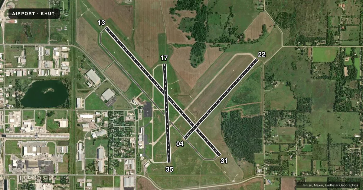
Runways & pattern
Full pagePattern entry · RWY 17
LEFT TRAFFIC| Runway | Heading (°M) | Length | Surface | Traffic |
|---|---|---|---|---|
| 13/31 | 134° / 314° | 7,003 ft | ASPH | Standard L |
| 04/22 | 38° / 218° | 4,405 ft | ASPH | Standard L |
| 17/35Favored | 173° / 353° | 4,012 ft | CONC | Standard L |
Runway end performance
| End | TORA | TODA | ASDA | LDA | VGSI | Approach lights | Obstruction |
|---|---|---|---|---|---|---|---|
| 13 | 7,003' | 7,003' | 7,003' | 7,003' | — | MALSR | 38', tree, 1627' from thr, 550' R of cntrln, slope 37 |
| 31 | 7,003' | 7,003' | 7,003' | 7,003' | VASI 4-box left(3°) | — | — |
| 04 | 4,401' | 4,401' | 4,401' | 4,401' | PAPI 4-box left(3°) | — | — |
| 22 | 4,401' | 4,401' | 4,401' | 4,401' | VASI 2-box left(3.4°) | — | 88', trees, 1450' from thr, 300' R of cntrln, slope 14 |
| 17 | 4,012' | 4,012' | 4,012' | 4,012' | PAPI 4-box left(3°) | — | — |
| 35 | 4,012' | 4,012' | 4,012' | 4,012' | PAPI 4-box left(3°) | — | — |
Declared distances in feet. TORA = takeoff run available, TODA = takeoff distance, ASDA = accelerate-stop, LDA = landing distance.
Airport sketch
Runways drawn to scale from FAA survey coordinates, rendered over satellite imagery. Not for navigation.
Approaches & charts
ILS · 1
Services on the field
Fuel grades, oxygen, maintenance, ramp storage and lighting — as declared to the FAA by the airport operator.
Fuel & services
- Fuel
- 100LLA
- Oxygen (bottled)
- Not available
- Oxygen (bulk)
- Low pressure
- Airframe repair
- Major
- Power plant repair
- Major
- Other services
- AFRT,CHTR,INSTR,RNTL
Ramp & ground
- Transient storage
- Tie-down
- Hangar
- Landing fee
- No fee published
- Customs
- Not available
- Lighting schedule
- SEE RMK
- Beacon schedule
- SS-SR
- Beacon
- White / Green (civil land)(WG)
- Wind indicator
- Lighted
- Segmented circle
- No
Fuel & FBOs
Cheapest 100LL and Jet A on the field and nearby. Always confirm with the FBO before taxi.
Airport notes
Surface conditions, obstructions, local procedures, lighting outages and other notes published with each FAA cycle.
General notes
- MIGRATORY BIRDS ON & INVOF ARPT.
- CROSSING RWYS USED FOR TAXIING TO AND FM ACTIVE RWYS.
- ARPT SFC CONDS UNMON FM 0300Z-1100Z.
- FOR CD CTC WICHITA APCH AT 316-350-1520.
- TWY B3 DSGND AS A NON-MOVEMENT AREA.
Lighting notes
- ACTVT MALSR RWY 13; PAPI RWY 4, 17, 35; VASI RWY 22; MIRL RWY 04/22 & 17/35; HIRL RWY 13/31 - CTAF.
Fuel notes
- 100LLSELF SERVICE 100LL FUEL AVBL N OF THE TRANSIENT APRON
Other notes
- 2ATTENDANT AFT HRS CALL 620-663-1546.
VFR map & nearby airports
VFR sectional. Tap any ICAO chip to open that airport.
Key facts · KHUT
Answer card- ICAO
- KHUT
- Name
- HUTCHINSON RGNL
- Location
- HUTCHINSON, KANSAS
- Elevation
- 1,542.5 ft MSL
- Traffic pattern altitude
- 2,542.5 ft MSL (1,000 AGL)
- Control tower
- Towered · 0600-2200
- Total runways
- 3
- Longest runway
- 13/31 · 7,003 ft
- Published ILS approaches
- 1
- Published frequencies
- 10
- Magnetic variation
- 4°
- Current flight rules
- VFR
- Current wind
- 180° at 16 kt
- Favored runway now
- RWY 17
Hutchinson Rgnl sits in Hutchinson, Kansas. Field elevation is 1,542.5 ft MSL. The airport has three runways. The longest is runway 13/31 at 7,003 ft. The field is towered from 0600 to 2200. One ILS is published for runway 13. Pattern altitude is not published in the facts. Use 1,000 ft AGL for light piston traffic unless the current Chart Supplement says otherwise.
Wells Aircraft is on the field. It carries 100LL and Jet A Prist. Self-serve 100LL is available north of the transient apron. An attendant is available after hours by calling the FBO. Runway lighting is mixed. Runway 13 has high intensity lights and MALSR. Runways 04, 17, 35 and 22 have visual glide path aids listed in the remarks. Crossing runways are used for taxiing to and from active runways. Taxiway B3 is a non-movement area.
For a first-time arrival, watch the bird activity. Migratory birds are present on and near the airport. Surface conditions are unmonitored from 0300Z to 1100Z. Use CTAF for communications when appropriate. For clearance delivery, contact Wichita Approach. Check the current Chart Supplement for any published noise or curfew restrictions before flying into the field.