METAR & TAF KHUF
Current METAR
Observed 16:53Z
KHUF 271653Z 24008KT 10SM CLR 33/25 A2985 RMK AO2 SLP100 T03280250
- Wind
- 240° @ 8 kt
- Visibility
- 10 SM
- Temp / Dew
- 33°C / 25°C
- Altimeter
- 29.85 inHg
- Clouds
- CLR
- Density alt
- 2,977 ft
- Ceiling
- Unlimited
- Rules
- VFR
Airport info & contacts
Manager on record, flight service, ARTCC, attendance schedule and pattern altitude — published by the FAA and refreshed every 28 days.
Location
- From city
- 5 NM E
- VFR sectional
- ST LOUIS
- ARTCC
- ZID · INDIANAPOLIS
- NOTAM facility
- HUF (NOTAM-D)
Airport manager
- Name
- CRAIG MASCHINO
- Phone
- 812-877-2524
- Address
- 581 S. AIRPORT ST., TERRE HAUTE IN 47803
Flight service · Hours
- FSS HUF
- TERRE HAUTE1-800-WX-BRIEF
- Attendance
- MON-FRI · 0700-1900
- 0700-1900
Frequencies
Tap any row to copy the frequency to your clipboard.
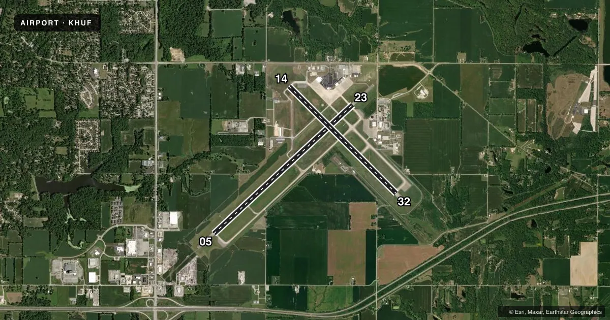
Runways & pattern
Full pagePattern entry · RWY 23
LEFT TRAFFIC| Runway | Heading (°M) | Length | Surface | Traffic |
|---|---|---|---|---|
| 05/23Favored | 45° / 225° | 9,021 ft | ASPH | Standard L |
| 14/32 | 133° / 313° | 7,200 ft | ASPH-CONC | Standard L |
Runway end performance
| End | TORA | TODA | ASDA | LDA | VGSI | Approach lights | Obstruction |
|---|---|---|---|---|---|---|---|
| 05 | 9,020' | 9,020' | 9,020' | 9,020' | PAPI 4-box left(3°) | MALSR | 54', stack, 2841' from thr, 412' R of cntrln, slope 48 |
| 23 | 9,020' | 9,020' | 9,020' | 9,020' | PAPI 4-box left(3°) | — | 71', tree, 2297' from thr, 535' R of cntrln, slope 29 |
| 14 | 7,200' | 7,200' | 7,200' | 7,200' | PAPI 4-box left(2.75°) | — | 105', tree, 2597' from thr, 341' R of cntrln, slope 22 |
| 32 | 7,200' | 7,200' | 7,200' | 7,200' | PAPI 4-box left(3°) | — | — |
Declared distances in feet. TORA = takeoff run available, TODA = takeoff distance, ASDA = accelerate-stop, LDA = landing distance.
Airport sketch
Runways drawn to scale from FAA survey coordinates, rendered over satellite imagery. Not for navigation.
Approaches & charts
ILS · 1
Services on the field
Fuel grades, oxygen, maintenance, ramp storage and lighting — as declared to the FAA by the airport operator.
Fuel & services
- Fuel
- 100LLA
- Oxygen (bottled)
- Not available
- Airframe repair
- Major
- Power plant repair
- Major
- Other services
- AFRT,CARGO,INSTR,RNTL
Ramp & ground
- Transient storage
- Tie-down
- Hangar
- Landing fee
- Yes
- Customs
- Not available
- Beacon schedule
- SS-SR
- Beacon
- White / Green (civil land)(WG)
- Wind indicator
- Lighted
- Segmented circle
- No
Fuel & FBOs
Cheapest 100LL and Jet A on the field and nearby. Always confirm with the FBO before taxi.
Airport notes
Surface conditions, obstructions, local procedures, lighting outages and other notes published with each FAA cycle.
General notes
- BIRDS ON & INVOF ARPT.
- ACFT SVCS AVBL MON-SAT 0700-2100, SUN 0700-1900. FUEL AVBL AFTER HRS,SUBJECT TO AFTER HRS CALLOUT FEE.
Runway surface & condition
- 05/23PCR VALUE: 450/F/D/X/T
- 14/32PCR VALUE: 650/F/D/X/T
- 05/231000 FT PAVED BLAST PAD SW END & 1325 FT PAVED BLAST PAD NE END; RY 32 400 FT BY 150 FT BLAST PAD; NOT AVBL FOR ASDA.
Other notes
- CLSD TO SKED ACR OPS GTR THAN 9 PSGR SEATS. UNSKED ACR OPS GTR THAN 30 PSGR SEATS RQR PPR - CTC 812-877-2524 OR 812-877-2252. INDEX B ARFF CAPABILITY AVBL ON REQ.
- LNDG FEE FOR CIVILIAN ACFT OVER 12,500 LBS.
- 2NO SVC ON HOL.
- 3NO SERVICE ON HOLIDAYS
VFR map & nearby airports
VFR sectional. Tap any ICAO chip to open that airport.
Key facts · KHUF
Answer card- ICAO
- KHUF
- Name
- TERRE HAUTE RGNL
- Location
- TERRE HAUTE, INDIANA
- Elevation
- 589.2 ft MSL
- Traffic pattern altitude
- 1,589.2 ft MSL (1,000 AGL)
- Control tower
- Towered · 24
- Total runways
- 2
- Longest runway
- 05/23 · 9,021 ft
- Published ILS approaches
- 1
- Published frequencies
- 10
- Magnetic variation
- 2°
- Current flight rules
- VFR
- Current wind
- 240° at 8 kt
- Favored runway now
- RWY 23
Terre Haute Rgnl sits in Terre Haute, Indiana. The field elevation is 589.2 ft MSL. It has 2 runways. The longest is 9,021 ft on 05/23. The tower is open 24 hours. One ILS approach is published for runway 05.
Pattern altitude is not published. Use 1,000 ft AGL for light piston operations unless ATC or the Chart Supplement says otherwise. Hoosier Aviation is on the field. It carries 100LL, Jet A and Jet A Prist. Call ahead if you need current ramp or fuel availability. Published remarks also note after-hours fuel with a callout fee. No service is published on holidays.
This is a busy controlled field with two long paved runways. Runway 05/23 has blast pads at both ends. Those pads do not count toward accelerate-stop distance available. Runway 14/32 is also paved. The airport remarks say birds are on and near the field. The airport is closed to scheduled aircraft operations greater than 9 passenger seats. Unscheduled aircraft over 30 passenger seats need prior permission. Check the current FAA Chart Supplement for any noise or curfew restrictions before flying in. Use the current Chart Supplement or call the airport operator for anything not listed here.