METAR & TAF KGUS
Current METAR
Observed 13:55Z
KGUS 271355Z AUTO 15004KT 9SM CLR 23/22 A2989 RMK AO2 SLP118 T02330217 TSNO $
- Wind
- 150° @ 4 kt
- Visibility
- 9 SM
- Temp / Dew
- 23°C / 22°C
- Altimeter
- 29.89 inHg
- Clouds
- CLR
- Density alt
- 2,002 ft
- Ceiling
- Unlimited
- Rules
- VFR
Airport info & contacts
Manager on record, flight service, ARTCC, attendance schedule and pattern altitude — published by the FAA and refreshed every 28 days.
Location
- From city
- 5 NM S
- VFR sectional
- CHICAGO
- ARTCC
- ZAU · CHICAGO
- NOTAM facility
- GUS (NOTAM-D)
Airport manager
- Name
- 434 ARW WING COMMANDER
- Phone
- 765-688-2613
- Address
- 434 AERIAL REFUELING WING, 7207 GRISSOM AVE, GRISSOM ARB IN 46971
Flight service · Hours
- FSS HUF
- TERRE HAUTE1-800-WX-BRIEF
Frequencies
Tap any row to copy the frequency to your clipboard.
Runways & pattern
Full pagePattern entry · RWY 23
LEFT TRAFFICRunway end performance
| End | TORA | TODA | ASDA | LDA | VGSI | Approach lights | Obstruction |
|---|---|---|---|---|---|---|---|
| 05 | — | — | — | — | PAPI 4-box left(2.5°) | ALSF1 | — |
| 23 | — | — | — | — | PAPI 4-box left(2.5°) | ALSF1 | — |
Declared distances in feet. TORA = takeoff run available, TODA = takeoff distance, ASDA = accelerate-stop, LDA = landing distance.
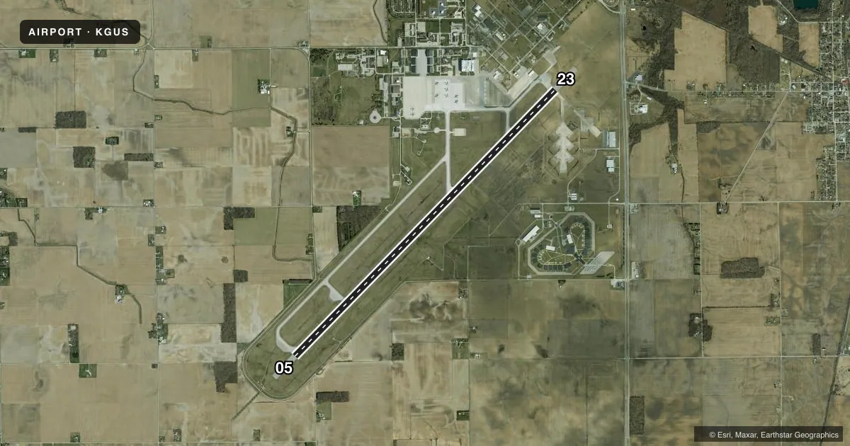
Airport sketch
Runways drawn to scale from FAA survey coordinates, rendered over satellite imagery. Not for navigation.
Approaches & charts
ILS · 2
Services on the field
Fuel grades, oxygen, maintenance, ramp storage and lighting — as declared to the FAA by the airport operator.
Fuel & services
- Fuel
- 100
- Oxygen (bulk)
- HIGH/LOW
- Airframe repair
- Major
- Power plant repair
- Major
- Other services
- CARGO
Ramp & ground
- Transient storage
- Hangar
- Landing fee
- No fee published
- Customs
- Not available
- Beacon schedule
- SS-SR
- Beacon
- White / Green (civil land)(WG)
- Wind indicator
- Yes
- Segmented circle
- No
Fuel & FBOs
Cheapest 100LL and Jet A on the field and nearby. Always confirm with the FBO before taxi.
Airport notes
Surface conditions, obstructions, local procedures, lighting outages and other notes published with each FAA cycle.
General notes
- JASU; A/M32A-86, MD-3, AM32-95 & MA-1A.
- RSTD: PAX/CARGO ACFT CTC COMMAND POST NLT 30 MIN PRIOR TO LNDG.
- BIRD WATCH COND: MNT ATIS; PHASE I NOV-APR & JUN LGT; PHASE II MAY, JUL-OCT HVY.
- CTN: UNCTLD VEHICLE ON MOVEMENT AREAS.
- SVC LGT - FLOODS.
- FLUID: SP PRESAIR LHOX.
- OIL: O-133-148-156 JOAP.
- TRANS ALERT: AVBL DURG OPS HRS; NO PRIORITY BASIS; SVC AVBL PRIOR ARNG; FLEET SVC NA.
- MISC: WX SVC AVBL DURG OPS HR - D388-2203/2204; C765-688-2203/2204.
- CTN: DURG RAIN EXP STANDING WATER ON RWY.
- GA PRAC APCH NA, ALFD IS OFFL BUS ONLY DUR HOTPIT REFUELING.
- FBO E END; PRIOR PMSN NOT RQR FOR ACFT LDG CIV FBO; CTC TWR; EXP TAXI INSTR; 100LL & JET A AVBL.
- CIV TRNG NA PER JOINT USE AGREEMENT.
- PPR FOR CIV ACFT ON MIL RAMP.
- SUA OVHD & NW; HVY & FIGHTER JET TRNG RMN NW WI 10 NM.
- EXP DELAY WHEN TACTICAL ARR & DEP TRNG IN PROG & DURG SNOW REMOVAL OPS.
- FOR RAPCON SVC - 121.05 OR 379.3
- CTN: RWY LGTS 28 FT FM EDGE.
- FUEL: MIL 1200-0400Z++; CLSD FEDERAL HOL.
- OPR 1230-0400Z++; CLSD FEDERAL HOL; FBO CLSD FRI 2200Z THRU MON 1230Z; PPR - AFLD OPS D388-2254/C765-688-2254.
- RWY COND CODES UNAVBL.
- RSTD: AFRC ACFT EXP RSTRN WHEN MOD OR HIGHER; NO LCL IFR/VFR TFC; OPS NA WO OG/CC APVL.
Runway surface & condition
- 05/23FIRST 1000 FT CONC; RMNG ASPH.
- 05/2350 FT NON WT BRG SHOULDER EA SIDE.
Other notes
- MANAGER765-688-2254.
VFR map & nearby airports
VFR sectional. Tap any ICAO chip to open that airport.
Key facts · KGUS
Answer card- ICAO
- KGUS
- Name
- GRISSOM ARB
- Location
- PERU, INDIANA
- Elevation
- 810.6 ft MSL
- Traffic pattern altitude
- 1,810.6 ft MSL (1,000 AGL)
- Control tower
- Towered · 1230-0400Z++, CLSD FED HOLS.
- Total runways
- 1
- Longest runway
- 05/23 · 12,501 ft
- Published ILS approaches
- 2
- Published frequencies
- 18
- Magnetic variation
- 2°
- Current flight rules
- VFR
- Current wind
- 150° at 4 kt
- Favored runway now
- RWY 23
Grissom ARB sits near Peru, Indiana. Field elevation is 810.6 ft MSL. The airport has one runway, 05/23, which is 12,501 ft long. The tower is open 1230-0400Z and is closed on federal holidays. Two ILS approaches are published, one for runway 05 and one for runway 23.
Pattern altitude is not published. Use the standard 1,000 ft AGL for light piston traffic unless the current FAA Chart Supplement says otherwise. The runway is long enough for heavy aircraft. This is a military field with special use airspace overhead and northwest. Heavy and fighter jet training also remains northwest within 10 NM. Expect that to matter on arrival and departure planning.
Miami County Aviation is on the field. It carries AVGAS 100LL, JET A and JET A PRIST. Fuel is reported as military during operating hours, which run from 1230 to 0400Z and beyond. The FBO is closed Friday 2200Z through Monday 1230Z. Prior permission is required for airfield operations. Runway 05/23 has concrete for the first 1,000 ft, then asphalt. The published remarks also note runway lights set 28 ft from the edge. Check the current FAA Chart Supplement and call the airport operator before you go.