METAR & TAF KGLS
Current METAR
Observed 08:52Z
KGLS 270852Z AUTO 22007KT 10SM FEW021 29/26 A2998 RMK AO2 SLP153 T02890256 56006
- Wind
- 220° @ 7 kt
- Visibility
- 10 SM
- Temp / Dew
- 29°C / 26°C
- Altimeter
- 29.98 inHg
- Clouds
- FEW
- Density alt
- 1,613 ft
- Ceiling
- Unlimited
- Rules
- VFR
Airport info & contacts
Manager on record, flight service, ARTCC, attendance schedule and pattern altitude — published by the FAA and refreshed every 28 days.
Location
- From city
- 3 NM SW
- VFR sectional
- HOUSTON
- ARTCC
- ZHU · HOUSTON
- NOTAM facility
- GLS (NOTAM-D)
Airport manager
- Name
- MIKE SHAHAN
- Phone
- 409-797-3590
- Address
- 2115 TERMINAL DRIVE, GALVESTON TX 77554
Flight service · Hours
- FSS CXO
- MONTGOMERY COUNTY1-800-WX-BRIEF
- Attendance
- 0600-2000
Frequencies
Tap any row to copy the frequency to your clipboard.
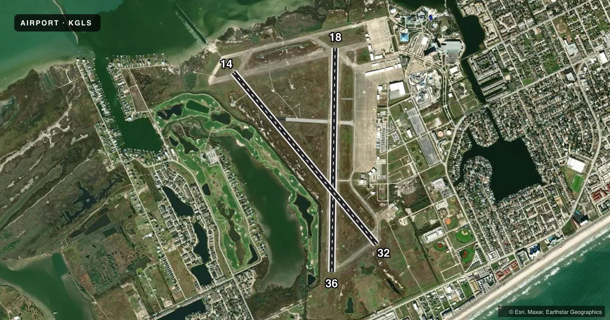
Runways & pattern
Full pagePattern entry · RWY 18
LEFT TRAFFIC| Runway | Heading (°M) | Length | Surface | Traffic |
|---|---|---|---|---|
| 18/36Favored | 179° / 359° | 6,001 ft | CONC | Standard L |
| 14/32 | 138° / 318° | 6,000 ft | ASPH-CONC | Standard L |
Runway end performance
| End | TORA | TODA | ASDA | LDA | VGSI | Approach lights | Obstruction |
|---|---|---|---|---|---|---|---|
| 18 | 6,001' | 6,001' | 6,001' | 6,001' | PAPI 4-box left(3°) | — | — |
| 36 | 6,001' | 6,001' | 6,001' | 6,001' | PAPI 4-box left(3°) | — | 120', bldg, 2970' from thr, 240' R of cntrln, slope 23 |
| 14 | 6,000' | 6,000' | 6,000' | 6,000' | PAPI 4-box left(3°) | MALSR | — |
| 32 | 6,000' | 6,000' | 5,819' | 5,819' | PAPI 4-box left(3°) | — | 80', bldg, 2492' from thr, 130' R of cntrln, slope 28 |
Declared distances in feet. TORA = takeoff run available, TODA = takeoff distance, ASDA = accelerate-stop, LDA = landing distance.
Airport sketch
Runways drawn to scale from FAA survey coordinates, rendered over satellite imagery. Not for navigation.
Approaches & charts
ILS · 1
Services on the field
Fuel grades, oxygen, maintenance, ramp storage and lighting — as declared to the FAA by the airport operator.
Fuel & services
- Fuel
- 100LLA+
- Oxygen (bottled)
- Not available
- Oxygen (bulk)
- Not available
- Airframe repair
- Major
- Power plant repair
- Major
- Other services
- CHTR,INSTR,RNTL
Ramp & ground
- Transient storage
- Tie-down
- Hangar
- Landing fee
- No fee published
- Customs
- Not available
- Lighting schedule
- SEE RMK
- Beacon schedule
- SS-SR
- Beacon
- White / Green (civil land)(WG)
- Wind indicator
- Lighted
- Segmented circle
- Yes
Fuel & FBOs
Cheapest 100LL and Jet A on the field and nearby. Always confirm with the FBO before taxi.
Airport notes
Surface conditions, obstructions, local procedures, lighting outages and other notes published with each FAA cycle.
General notes
- FLOCKS OF BIRDS INVOF ARPT BLW 200 FT AGL.
- HELS OPRG ON & INVOF ARPT.
- 178 FT LGTD BLDG 1800 FT NE OF RWY 18 THR.
- PAEW ADJ RWYS & TWYS.
- FOR CD WHEN ATCT IS CLSD CTC HOUSTON APCH AT 281-443-5844 TO CNL IFR AT 281-443-5888.
- PILOTS CONDUCTING EFVS OPS; BE AWARE LED ALS IN USE RWY 14.
Lighting notes
- HIRL RWY 14/32, MIRL RWY 18/36 PRESET ON MED INTST. TO INCR INTST & ACTVT MALSR RWY 14 - CTAF. PAPI RWYS 14, 18, 32 & 36 OPR CONSLY.
Fuel notes
- 100LLAFT HRS SVC 409-750-0195.
Other notes
- 14/32FIRST 1300 FT NW END IS CONC.
VFR map & nearby airports
VFR sectional. Tap any ICAO chip to open that airport.
Key facts · KGLS
Answer card- ICAO
- KGLS
- Name
- SCHOLES INTL AT GALVESTON
- Location
- GALVESTON, TEXAS
- Elevation
- 5.6 ft MSL
- Traffic pattern altitude
- 1,005.6 ft MSL (1,000 AGL)
- Control tower
- Towered · 0600-1800
- Total runways
- 2
- Longest runway
- 18/36 · 6,001 ft
- Published ILS approaches
- 1
- Published frequencies
- 7
- Magnetic variation
- 2°
- Current flight rules
- VFR
- Current wind
- 220° at 7 kt
- Favored runway now
- RWY 18
Scholes Intl at Galveston is in Galveston, Texas. The field elevation is 5.6 ft MSL, so this is a low coastal airport with little room for error on a hot or humid day. KGLS has two runways. The longest is 6,001 ft. Runway 14/32 is 6,000 ft. Runway 18/36 is 6,001 ft. The tower is open daily from 0600 to 1800. Outside those hours, use the published Houston Approach and airport contact procedures in the Chart Supplement.
There is one ILS approach. It serves runway 14. Pattern altitude is not published in the facts, so use the standard 1,000 ft AGL for light piston traffic unless ATC or the current Chart Supplement says otherwise. Island Jet Center is on the field. It carries 100LL and Jet A Prist. After-hours 100LL service is listed by phone. The published remarks also call out birds below 200 ft AGL. They also note a 178-foot lighted building 1,800 ft northeast of the runway 18 threshold. Helicopter activity on and near the airport is also published. Runway 14/32 has a concrete first 1,300 ft at the northwest end. The runway lights and PAPI are available on the published ends, so brief the approach carefully before arrival.