METAR & TAF KGGG
Current METAR
Observed 14:53Z
KGGG 271453Z 25007KT 10SM CLR 31/22 A2999 RMK AO2 SLP146 T03110217 50005
- Wind
- 250° @ 7 kt
- Visibility
- 10 SM
- Temp / Dew
- 31°C / 22°C
- Altimeter
- 29.99 inHg
- Clouds
- CLR
- Density alt
- 2,286 ft
- Ceiling
- Unlimited
- Rules
- VFR
Airport info & contacts
Manager on record, flight service, ARTCC, attendance schedule and pattern altitude — published by the FAA and refreshed every 28 days.
Location
- From city
- 8 NM S
- VFR sectional
- MEMPHIS
- ARTCC
- ZFW · FORT WORTH
- NOTAM facility
- GGG (NOTAM-D)
Airport manager
- Name
- MAX TOVAR, MBA
- Phone
- 903-234-3194
- Address
- 269 TERMINAL CIRCLE, LONGVIEW TX 75603
Flight service · Hours
- FSS FTW
- FORT WORTH1-800-WX-BRIEF
- Attendance
- 0600-2100
Frequencies
Tap any row to copy the frequency to your clipboard.
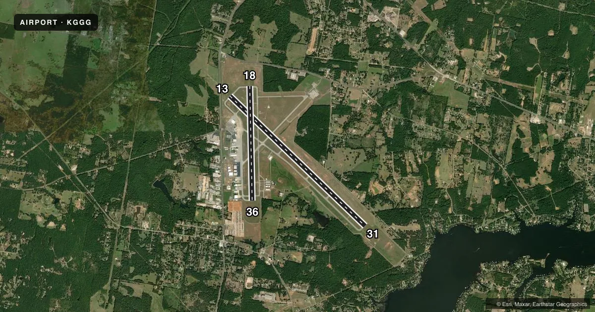
Runways & pattern
Full pagePattern entry · RWY 31
LEFT TRAFFIC| Runway | Heading (°M) | Length | Surface | Traffic |
|---|---|---|---|---|
| 13/31Favored | 131° / 311° | 10,000 ft | ASPH | Standard L |
| 18/36 | 176° / 356° | 6,110 ft | ASPH | Standard L |
Runway end performance
| End | TORA | TODA | ASDA | LDA | VGSI | Approach lights | Obstruction |
|---|---|---|---|---|---|---|---|
| 13 | 10,000' | 10,000' | 10,000' | 9,200' | — | MALSR | — |
| 31 | 10,000' | 10,000' | 9,200' | 9,200' | PAPI 4-box left(3°) | — | — |
| 18 | 6,109' | 6,109' | 6,109' | 6,109' | PAPI 4-box left(3°) | — | 46', tree, 1584' from thr, 465' R of cntrln, slope 30 |
| 36 | 6,109' | 6,109' | 6,109' | 6,109' | PAPI 4-box right(3°) | — | 52', tree, 1813' from thr, 446' R of cntrln, slope 31 |
Declared distances in feet. TORA = takeoff run available, TODA = takeoff distance, ASDA = accelerate-stop, LDA = landing distance.
Airport sketch
Runways drawn to scale from FAA survey coordinates, rendered over satellite imagery. Not for navigation.
Approaches & charts
ILS · 1
Services on the field
Fuel grades, oxygen, maintenance, ramp storage and lighting — as declared to the FAA by the airport operator.
Fuel & services
- Fuel
- 100LLA
- Oxygen (bottled)
- HIGH/LOW
- Oxygen (bulk)
- Not available
- Airframe repair
- Major
- Power plant repair
- Major
- Other services
- AFRT,CHTR,INSTR,RNTL,SALES
Ramp & ground
- Transient storage
- Tie-down
- Hangar
- Landing fee
- No fee published
- Customs
- Not available
- Lighting schedule
- SEE RMK
- Beacon schedule
- SS-SR
- Beacon
- White / Green (civil land)(WG)
- Wind indicator
- Lighted
- Segmented circle
- Yes
Fuel & FBOs
Cheapest 100LL and Jet A on the field and nearby. Always confirm with the FBO before taxi.
Airport notes
Surface conditions, obstructions, local procedures, lighting outages and other notes published with each FAA cycle.
General notes
- BIRDS ON & INVOF ARPT (SEASONAL).
Lighting notes
- HIRL RWY 13/31 PRESET MED INTST; TO INCR INTST ACTVT - CTAF. WHEN ATCT CLSD ACTVT MALSR RWY 13 - CTAF. MIRL RWY 18/36 NOT AVBL WHEN ATCT CLSD.
Fuel notes
- 100LLFOR FUEL AFT HRS CALL 903-643-8748.
Runway surface & condition
- 13/31PCR VALUE: 503/F/B/X/T
- 18/36PCR VALUE: 311/F/D/X/T
Approach & departure obstructions
- 13+7 FT ROAD 194 FT FM THR 474 FT R.
- 36PAPI UNSBL BYD 8 DEG RIGHT OF RCL.
Other notes
- PPR FOR UNSCHEDULED ACR OPNS WITH OVER 30 PSGR SEATS. INDEX B AVBL ON REQUEST.
VFR map & nearby airports
VFR sectional. Tap any ICAO chip to open that airport.
Key facts · KGGG
Answer card- ICAO
- KGGG
- Name
- EAST TEXAS RGNL
- Location
- LONGVIEW, TEXAS
- Elevation
- 365.5 ft MSL
- Traffic pattern altitude
- 1,365.5 ft MSL (1,000 AGL)
- Control tower
- Towered · 0600-2200
- Total runways
- 2
- Longest runway
- 13/31 · 10,000 ft
- Published ILS approaches
- 1
- Published frequencies
- 22
- Magnetic variation
- 3°
- Current flight rules
- VFR
- Current wind
- 250° at 7 kt
- Favored runway now
- RWY 31
East Texas Rgnl is in Longview, Texas. Field elevation is 365.5 ft MSL. The airport has two asphalt runways. The longest is Runway 13/31 at 10,000 ft. Runway 18/36 is 6,110 ft. The tower is open daily from 0600 to 2200.
Runway 13 has the ILS approach. Pattern altitude is not published, so use the standard 1,000 ft AGL for light piston operations unless ATC or the current FAA Chart Supplement says otherwise. KRS Jet Center is on the field. It carries 100LL and Jet A. Call them at (903) 643-2010 for current service details. After hours fuel is handled by phone at 903-643-8748.
A few operational notes matter here. Runway 13/31 lighting is preset to medium intensity. Use CTAF to increase intensity. When the tower is closed, CTAF also activates the MALSR for Runway 13. Medium intensity runway lights for Runway 18/36 are not available when the tower is closed. There is a small road obstruction near the Runway 13 threshold. Birds are reported seasonally in and around the airport. Check the current FAA Chart Supplement before arrival for any noise or curfew restrictions, especially if you are planning an unscheduled operation or a larger cabin aircraft.