METAR & TAF KFLL
Current METAR
Observed 07:53Z
KFLL 280753Z 25003KT 10SM FEW025 FEW250 26/25 A2987 RMK AO2 SLP114 T02610250 PNO $
- Wind
- 250° @ 3 kt
- Visibility
- 10 SM
- Temp / Dew
- 26°C / 25°C
- Altimeter
- 29.87 inHg
- Clouds
- FEW
- Density alt
- 1,463 ft
- Ceiling
- Unlimited
- Rules
- VFR
Airport info & contacts
Manager on record, flight service, ARTCC, attendance schedule and pattern altitude — published by the FAA and refreshed every 28 days.
Location
- From city
- 3 NM SW
- VFR sectional
- MIAMI
- ARTCC
- ZMA · MIAMI
- NOTAM facility
- FLL (NOTAM-D)
Airport manager
- Name
- MARK GALE
- Phone
- 954-359-6100
- Address
- 320 TERMINAL DRIVE SUITE 200, FORT LAUDERDALE FL 33315
Flight service · Hours
- FSS MIA
- MIAMI1-800-WX-BRIEF
- Attendance
- ALL
Frequencies
Tap any row to copy the frequency to your clipboard.
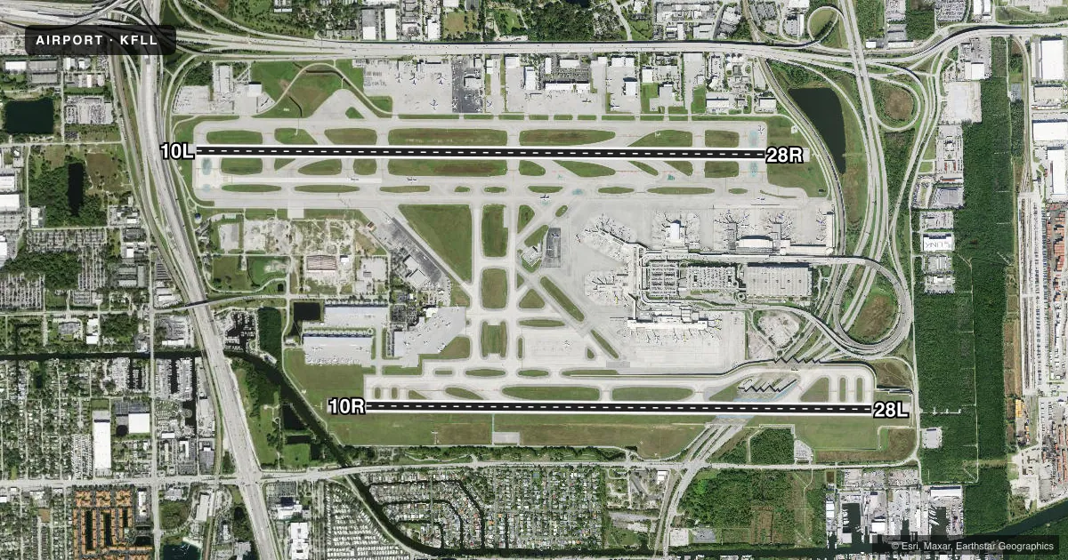
Runways & pattern
Full pagePattern entry · RWY 28R
RIGHT TRAFFIC| Runway | Heading (°M) | Length | Surface | Traffic |
|---|---|---|---|---|
| 10L/28RFavored | 84° / 264° | 9,000 ft | ASPH-CONC | 28R R |
| 10R/28L | 84° / 264° | 8,000 ft | CONC | 10R R |
Runway end performance
| End | TORA | TODA | ASDA | LDA | VGSI | Approach lights | Obstruction |
|---|---|---|---|---|---|---|---|
| 10L | 9,000' | 9,000' | 9,000' | 8,424' | PAPI 4-box left(3°) | MALSR | 14', road, 340' from thr, 0' R of cntrln, slope 10 |
| 28R | 9,000' | 9,000' | 9,000' | 8,394' | PAPI 4-box left(3°) | MALSR | 33', rr, 470' from thr, 530' R of cntrln, slope 8 |
| 10R | 8,000' | 8,000' | 8,000' | 8,000' | PAPI 4-box right(3°) | MALSF | 35', pole, 865' from thr, 587' R of cntrln, slope 18 |
| 28L | 8,000' | 8,000' | 8,000' | 8,000' | PAPI 4-box left(3°) | MALSF | — |
Declared distances in feet. TORA = takeoff run available, TODA = takeoff distance, ASDA = accelerate-stop, LDA = landing distance.
Airport sketch
Runways drawn to scale from FAA survey coordinates, rendered over satellite imagery. Not for navigation.
Approaches & charts
ILS · 4
Services on the field
Fuel grades, oxygen, maintenance, ramp storage and lighting — as declared to the FAA by the airport operator.
Fuel & services
- Fuel
- 100LLA
- Oxygen (bottled)
- HIGH/LOW
- Oxygen (bulk)
- HIGH/LOW
- Airframe repair
- Major
- Power plant repair
- Major
- Other services
- AFRT,AMB,AVNCS,CARGO,CHTR,INSTR,RNTL,SALES,SURV
Ramp & ground
- Transient storage
- Tie-down
- Hangar
- Landing fee
- No fee published
- Customs
- Available
- Lighting schedule
- SS-SR
- Beacon schedule
- SS-SR
- Beacon
- White / Green (civil land)(WG)
- Wind indicator
- Yes
- Segmented circle
- No
Fuel & FBOs
Cheapest 100LL and Jet A on the field and nearby. Always confirm with the FBO before taxi.
Airport notes
Surface conditions, obstructions, local procedures, lighting outages and other notes published with each FAA cycle.
General notes
- CLSD TO ACR TRAINING.
- ALL RWYS NOISE SENSITIVE; NOISE ABATEMENT IN EFCT - 954-359-6181.
- JET RUNUPS NA 2300-0700.
- BIRDS ON & INVOF ARPT; CONCENTRATION OF BIRDS BLW 500 FT 2.0 NM W OF 10L & 10R AER.
- PPR FOR ACFT WITH EXPLOSIVES.
- TWY E BTN TWY C & TWY L CLSD TO ACFT WINGSPAN MORE THAN 118 FT EXC 10 MIN PPR 954-816-3179.
- ARR FM N & W MNTN 6000 FT UNTIL ABM RWY 28R ON DOWNWIND; ARR FM N MNTN 6000 FT UNTIL ABM RWY 10L ON DOWNWIND.
- NO VFR APCHS OR BASE LEGS UNTIL OFFSHORE.
- IR CARRIER ACFT USE RAMP PUSH BACK PROCS PRESCRIBED BY ARPT OPS.
- EAST SIDE OF CONCOURSE B AVBL TO ACFT WITH WINGSPAN LESS THAN 124.9 FT.
- ACFT OPRG FROM TRML 1, 2, 3, 4 MUST CTC RAMP CTL. RAMP CTL EFF - CTC ARPT OPS FOR HRS.
- TURB BLW 1000 FT OVR LANDFILL LCTD 2 NM W.
- TWY J BGN TO ELEV 900 FT EAST OF TWY Q. DUE TO ELEV ALL ACFT REMAIN ON CNTRLN; TWY T8 & TAXILANE T NOT ACCESSIBLE FM TWY J.
- RWY STATUS LIGHTS IN OPRN.
- ACFT LDG RWY 10R & EXITING J9 FOLLOW TWY LEAD OFF LINE ONTO J9.
- PREFERENTIAL RWY USE PROGRAM IN EFCT; CTC NOISE ABATEMENT OFFICE.
- NMRS TREES SW QUADRANT OF ARPT.
- HIGH LIGHT MASTS WNW APCH END RWY 28L.
- APN TWY T EAST OF TWY T8 CLSD TO ACFT WINGSPAN MORE THAN 118 FT AND TAIL HEIGHT MORE THAN 45FT EXC ACFT UNDER TOW.
- TXL T BTN T7 AND T8 CLSD TO ACFT WINGSPAN MORE THAN 171 FT.
- DO NOT MISTAKE TWY B FOR LNDG/TKOF SFC.
- RWY 10L/28R NRS UNGROOVED AREAS.
- DO NOT MISTAKE TAXIWAY B FOR LANDING/TAKEOFF SURFACE.
- TWY B E OF TWY B12 & TXL T E OF TWY T1 CLSD TO ACFT WITH WINGSPAN GTR THAN 118 FT & TAIL HGT GTR THAN 45 FT EXC PPR 954-816-3179.
- 24 HOUR PPR FOR ACFT EQUIPPED WITH WEATHER MODIFICATION OR GEOENGINEERING EQUIPMENT 954-816-3179
Runway surface & condition
- 10L/28RST 175
- 10L/28RPCR VALUE: 930/R/A/W/T
- 10R/28LPCR VALUE: 820/R/A/W/T
Approach & departure obstructions
- 10RRWY 10R MALSF NSTD; 370 FT GAP BTN 8+00 & STATION 11+70.
- 10L+8 FT FENCE 200 FT FM THR & 400 FT R; 40 FT LGT POLES PARL TO RWY BTN TWY Q & A-4 650 FT N.
- 10LAPCH RATIO 50:1 TO DSPLCD THR.
- 28RAPCH RATIO 32:1 TO DSPLCD THR; +43 FT LGTD POLE 1414 FT FM THR 75 FT R; APCH RATIO 46:1.
Arresting gear
- 10L_EMASARSTG GEAR/SYS: ENGRD MTRLS ARSTG SYS (EMAS) 409 FT IN LEN BY 170 FT IN WID AT THE DEP END OF RWY 10L.
- 10R_EMASARSTG GEAR/SYS: ENGRD MTRLS ARSTG SYS (EMAS) 562.9 FT IN LEN BY 178.2 FT IN WID AT THE DEP END OF RWY 10R.
- 28L_EMASARSTG GEAR/SYS: ENGRD MTRLS ARSTG SYS (EMAS) 562.9 FT IN LEN BY 178.2 FT IN WID AT THE DEP END OF RWY 28L.
- 28R_EMASARSTG GEAR/SYS: ENGRD MTRLS ARSTG SYS (EMAS) 251 FT IN LEN BY 170 FT IN WID AT THE DEP END OF RWY 28R.
Other notes
- 10R/28LRWY 10R/28L NRS UNGROOVED AREAS.
VFR map & nearby airports
VFR sectional. Tap any ICAO chip to open that airport.
Key facts · KFLL
Answer card- ICAO
- KFLL
- Name
- FORT LAUDERDALE/HOLLYWOOD INTL
- Location
- FORT LAUDERDALE, FLORIDA
- Elevation
- 65 ft MSL
- Traffic pattern altitude
- 1,065 ft MSL (1,000 AGL)
- Control tower
- Towered · 24
- Total runways
- 2
- Longest runway
- 10L/28R · 9,000 ft
- Published ILS approaches
- 4
- Published frequencies
- 21
- Magnetic variation
- 6°
- Current flight rules
- VFR
- Current wind
- 250° at 3 kt
- Favored runway now
- RWY 28R
Fort Lauderdale/Hollywood Intl is in Fort Lauderdale, Florida. Field elevation is 65 ft MSL. The airport has 2 runways. The longest is 10L/28R at 9,000 ft. Tower service is 24 hours. Four ILS approaches serve the field, with coverage for 10L, 10R, 28L and 28R.
Pattern altitude is not published in the facts. Use the current FAA Chart Supplement before arrival. The field is busy and ramp control is required for aircraft using Terminals 1, 2, 3 and 4. Contact airport operations for ramp control hours. Noise abatement procedures are in effect on all runways. Jet runups are not authorized between 2300 and 0700. Birds are a real factor here. There is a concentration below 500 feet within 2.0 NM west of the 10L and 10R approach end.
On-field FBOs are Signature Aviation, Fontainblueau Aviation, National Jets and Sheltair. They carry AVGAS 100LL and Jet A. Fontainblueau Aviation, National Jets and Sheltair also carry Jet A Prist. Taxiway and wingspan limits matter here. Some taxiways and apron areas have restrictions for larger aircraft. Verify current taxi routing with the airport operator or ramp control. The airport sits in a dense South Florida environment, so expect heavy traffic and pay close attention to ATIS, taxi instructions and runway assignment.