METAR & TAF KFAR
Current METAR
Observed 00:53Z
KFAR 280053Z 35007KT 10SM CLR 30/21 A2981 RMK AO2 SLP090 T03000211 $
- Wind
- 350° @ 7 kt
- Visibility
- 10 SM
- Temp / Dew
- 30°C / 21°C
- Altimeter
- 29.81 inHg
- Clouds
- CLR
- Density alt
- 3,054 ft
- Ceiling
- Unlimited
- Rules
- VFR
Airport info & contacts
Manager on record, flight service, ARTCC, attendance schedule and pattern altitude — published by the FAA and refreshed every 28 days.
Location
- From city
- 3 NM NW
- VFR sectional
- TWIN CITIES
- ARTCC
- ZMP · MINNEAPOLIS
- NOTAM facility
- FAR (NOTAM-D)
Airport manager
- Name
- SHAWN DOBBERSTEIN
- Phone
- 701-241-1501
- Address
- PO BOX 2845, FARGO ND 58108
Flight service · Hours
- FSS GFK
- GRAND FORKS1-800-WX-BRIEF
- Attendance
- ALL
Frequencies
Tap any row to copy the frequency to your clipboard.
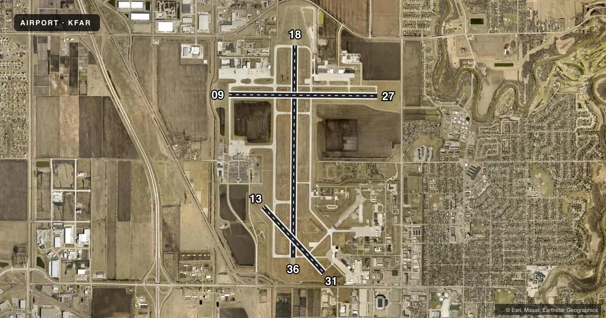
Runways & pattern
Full pagePattern entry · RWY 36
LEFT TRAFFIC| Runway | Heading (°M) | Length | Surface | Traffic |
|---|---|---|---|---|
| 18/36Favored | 176° / 356° | 9,001 ft | CONC | Standard L |
| 09/27 | 86° / 266° | 6,302 ft | CONC | Standard L |
| 13/31 | 133° / 313° | 3,801 ft | CONC | Standard L |
Runway end performance
| End | TORA | TODA | ASDA | LDA | VGSI | Approach lights | Obstruction |
|---|---|---|---|---|---|---|---|
| 18 | 9,001' | 9,001' | 9,001' | 9,001' | PAPI 4-box left(3°) | MALSR | — |
| 36 | 9,001' | 9,001' | 9,001' | 9,001' | PAPI 4-box right(3°) | MALSR | — |
| 09 | 6,302' | 6,302' | 6,302' | 6,302' | PAPI 4-box left(3°) | — | — |
| 27 | 6,302' | 6,302' | 6,302' | 6,302' | PAPI 4-box left(3°) | — | 25', pole, 1086' from thr, 468' R of cntrln, slope 35 |
| 13 | 3,801' | 3,801' | 3,801' | 3,801' | PAPI 2-box right(3°) | — | 7', road, 550' from thr, 180' R of cntrln, slope 47 |
| 31 | 3,801' | 3,801' | 3,801' | 3,801' | PAPI 2-box left(3°) | — | 8', road, 432' from thr, 147' R of cntrln, slope 29 |
Declared distances in feet. TORA = takeoff run available, TODA = takeoff distance, ASDA = accelerate-stop, LDA = landing distance.
Airport sketch
Runways drawn to scale from FAA survey coordinates, rendered over satellite imagery. Not for navigation.
Approaches & charts
ILS · 2
Services on the field
Fuel grades, oxygen, maintenance, ramp storage and lighting — as declared to the FAA by the airport operator.
Fuel & services
- Fuel
- 100LLAA+A++J8
- Oxygen (bottled)
- HIGH/LOW
- Oxygen (bulk)
- HIGH/LOW
- Airframe repair
- Major
- Power plant repair
- Major
- Other services
- AMB,AVNCS,CHTR,INSTR,RNTL,SALES,SURV
Ramp & ground
- Transient storage
- Tie-down
- Hangar
- Landing fee
- No fee published
- Customs
- Not available
- Beacon
- White / Green (civil land)(WG)
- Wind indicator
- Lighted
- Segmented circle
- No
Fuel & FBOs
Cheapest 100LL and Jet A on the field and nearby. Always confirm with the FBO before taxi.
Airport notes
Surface conditions, obstructions, local procedures, lighting outages and other notes published with each FAA cycle.
General notes
- TWY B N OF TWY D RSTRD TO ACFT LESS THAN 130,000 LBS.
- FLIGHT NOTIFICATION SERVICE (ADCUS) AVAILABLE MON-FRI 0830-1700.
- MILITARY: ANG: OFFL BUS ONLY CTC BASE OPS DSN 362-8508, C701-451-2508 OPR 1130-2200Z++ CLSD FRI, SAT, SUN & HOL EXC DUR SKED TRNG. OTHER TRAN ACFT CTC JET CNTR C701-235-3600; CSTMS AVBL 24 HR. RCR AVBL FR ANG OPS ON 262.0. RGT TFC RWY 18.
- BIRDS ON AND INVOF ARPT.
- REMARKS: SEE FLIP AP/1 SUPPLEMENTARY ARPT INFO INCL BASH INFO.
- CAUTION: USE EXTREME CAUTION FOR UAS OPS IN VCNTY.
- ANG: BIRD HAZARD (BASH PHASE II) MAR-MAY, AUG-DEC.
Runway surface & condition
- 18/36AUW-847
- 09/27PCR VALUE: 263/R/D/W/U
- 18/36PCR VALUE: 855/R/D/W/U
- 13/31RWY 13/31 NOT AVBL FOR PART 121/PART 380 OPS WITH SKED PAX CARRYING OPS MORE THAN 9 PAX SEATS AND NON-SKED PAX CARRYING OPS MORE THAN 30 PAX SEATS.
Other notes
- INDEX E ARFF AVBL 2 HOURS PPR CTC 701-476-6790.
VFR map & nearby airports
VFR sectional. Tap any ICAO chip to open that airport.
Key facts · KFAR
Answer card- ICAO
- KFAR
- Name
- HECTOR INTL
- Location
- FARGO, NORTH DAKOTA
- Elevation
- 901.3 ft MSL
- Traffic pattern altitude
- 1,901.3 ft MSL (1,000 AGL)
- Control tower
- Towered · 24
- Total runways
- 3
- Longest runway
- 18/36 · 9,001 ft
- Published ILS approaches
- 2
- Published frequencies
- 17
- Magnetic variation
- 4°
- Current flight rules
- VFR
- Current wind
- 350° at 7 kt
- Favored runway now
- RWY 36
Hector Intl sits in Fargo, North Dakota. Field elevation is 901.3 ft MSL. The airport has three concrete runways. The longest is 18/36 at 9,001 ft. The tower is open 24 hours. Two ILS approaches are published. They serve runway ends 18 and 36.
Pattern altitude is not published in the facts. Use the standard 1,000 ft AGL for light piston traffic unless the current Chart Supplement says otherwise. Fargo Jet Center is the on-field FBO. It carries 100LL, Jet A and Jet A Prist. Call ahead at (701) 373-8840 if you need current ramp or service details.
This field has some operational notes that matter on a first visit. Military Air National Guard official business has priority. Transient aircraft are told to contact the jet center. Customs is available 24 hours. Right traffic is published for runway 18. Bird activity is a known issue here, with a seasonal hazard phase called out in the remarks. Taxiway B north of taxiway D is restricted to aircraft under 130,000 pounds. Runway 13/31 also has a published limitation for certain scheduled passenger operations. Check the current Chart Supplement before you go. Fargo is a busy controlled field. Expect standard tower procedures. Be ready for a quick readback.