METAR & TAF KCMY
Current METAR
Observed 15:55Z
KCMY 271555Z AUTO 26010KT 10SM FEW021 33/27 A2965 RMK AO2 SLP036 T03250267 $
- Wind
- 260° @ 10 kt
- Visibility
- 10 SM
- Temp / Dew
- 33°C / 27°C
- Altimeter
- 29.65 inHg
- Clouds
- FEW
- Density alt
- 3,536 ft
- Ceiling
- Unlimited
- Rules
- VFR
Airport info & contacts
Manager on record, flight service, ARTCC, attendance schedule and pattern altitude — published by the FAA and refreshed every 28 days.
Location
- From city
- 3 NM NE
- VFR sectional
- CHICAGO
- ARTCC
- ZAU · CHICAGO
- NOTAM facility
- CMY (NOTAM-D)
Airport manager
- Name
- JAMES HUBBARD
- Phone
- 502-898-4107
- Address
- ATTN: AMIM-MCO-A, FORT MC COY WI 54656
Flight service · Hours
- FSS GRB
- GREEN BAY1-800-WX-BRIEF
- Attendance
- MON-FRI · 1400-2200Z++
Frequencies
Tap any row to copy the frequency to your clipboard.
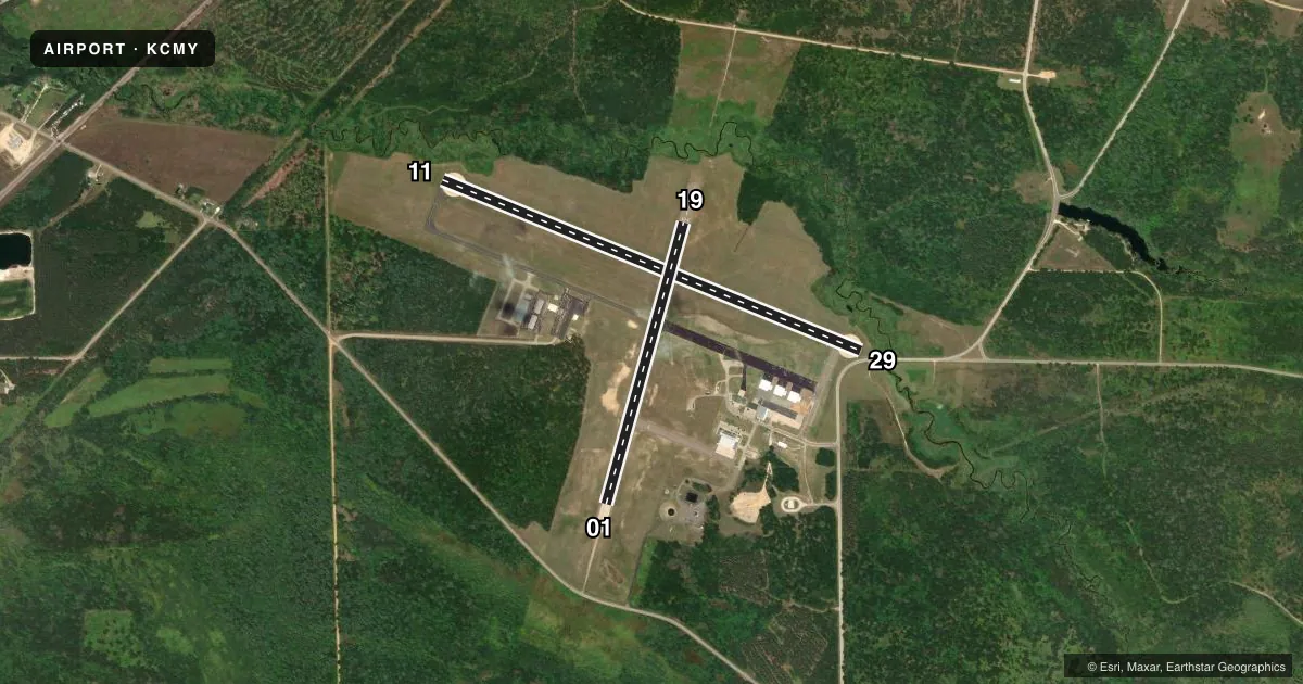
Runways & pattern
Full pagePattern entry · RWY 29
LEFT TRAFFIC| Runway | Heading (°M) | Length | Surface | Traffic |
|---|---|---|---|---|
| 11/29Favored | 112° / 292° | 4,697 ft | ASPH | Standard L |
| 01/19 | 15° / 195° | 3,032 ft | ASPH | Standard L |
Runway end performance
| End | TORA | TODA | ASDA | LDA | VGSI | Approach lights | Obstruction |
|---|---|---|---|---|---|---|---|
| 11 | — | — | — | — | PAPI 4-box left(3°) | — | 55', trees, 1315' from thr, 210' R of cntrln, slope 20 |
| 29 | — | — | — | — | PAPI 4-box left(3°) | — | 15', road, 200' from thr, 10' R of cntrln, slope 0 |
| 01 | — | — | — | — | PAPI 2-box left(3.5°) | — | — |
| 19 | — | — | — | — | PAPI 2-box left(3.5°) | — | — |
Declared distances in feet. TORA = takeoff run available, TODA = takeoff distance, ASDA = accelerate-stop, LDA = landing distance.
Airport sketch
Runways drawn to scale from FAA survey coordinates, rendered over satellite imagery. Not for navigation.
Approaches & charts
Services on the field
Fuel grades, oxygen, maintenance, ramp storage and lighting — as declared to the FAA by the airport operator.
Fuel & services
- Fuel
- 100LLA++
- Other services
- INSTR
Ramp & ground
- Transient storage
- Tie-down
- Lighting schedule
- SEE RMK
- Beacon schedule
- SS-SR
- Beacon
- White / Green (civil land)(WG)
- Wind indicator
- Lighted
- Segmented circle
- No
Fuel & FBOs
Cheapest 100LL and Jet A on the field and nearby. Always confirm with the FBO before taxi.
Airport notes
Surface conditions, obstructions, local procedures, lighting outages and other notes published with each FAA cycle.
General notes
- BIRDS & WILDLIFE ON & INVOF ARPT.
- 24 HR PPR FOR SVC AFT 2200Z++ - C502-898-4107. CLSD FED HOL & BY NOTAM. FUEL & T RQMNTS - AP/1.
- FICON UNMNT AFT HR.
- SNOW REMOVAL OPS MNT CTAF WHEN ATCT CLSD.
- LGTD WINDCONE RWY 01 & 11.
- RAPIDLY RISING TRRN 1 NM NW - NE.
- C130 & LRGR 180 DEG TURNS PMTD ON CONC SFC RWY 11/29 E & W ENDS & RWY 01/19 S END.
- R6901B 500 YDS DEP END RWY 11.
- RWY 01, 11, 29 NSTD SAFETY AREA BYD EACH END DUE TO TRRN & FENCE.
- PAJA 3.5 NM E - NE YEAR ROUND.
- RSTD: ARFF SVC AVBL WITH 72 HR NOTICE - C502-898-2508/3553; INDEX B SVC AVBL H24.
- FOR CD WHEN ATCT CLSD CTC CHICAGO ARTCC AT 630-906-8921.
Lighting notes
- WHEN TWR CLSD ACTVT REIL RWY 11 & 29; MIRL RWY 01/19 - CTAF. MIRL RWY 11/29 PRESET TO LOW SS-SR; INCR INTST CTAF. VGSI RWY 01, 11, 19 & 29 OPR CONSLY.
Fuel notes
- 100LLCREDIT CARD SELF SVC H24 ON CIVIL RAMP.
- A++MIL RAMP SELF SVC H24 1 APR - 30 SEP & MON-FRI 1 OCT - 31 MAR TO TRAINED AIRCREW ONLY. 1 OCT - 31 MAR PPR BY THURS 2200Z++ FOR WKEND FUEL OR SVC; C502-898-4107.
Runway surface & condition
- 11/29HVY ASSAULT STRIP OPS E. NSTD N LATERAL CLNC; SEE KCMY AP/1 FOR INFO.
Approach & departure obstructions
- 2915 FT ROAD 0-200 FT FM RWY END 0-107 FT L.
- 11CTN: DEP; VEHICLES ON ROAD MAY APPEAR TO BE ON RWY.
- 19CTLD SMALL ARMS RANGE 1000 YDS DEP END.
- 29APCH RATIO 34:1 TO DTHR.
Other notes
- 1EXC FED HOL.
- MANAGERCIVIL AMGR MARK VAN WORMER - 608-269-4340 EX: 9-5157.
VFR map & nearby airports
VFR sectional. Tap any ICAO chip to open that airport.
Key facts · KCMY
Answer card- ICAO
- KCMY
- Name
- SPARTA/FORT MC COY
- Location
- SPARTA, WISCONSIN
- Elevation
- 839.4 ft MSL
- Traffic pattern altitude
- 1,839.4 ft MSL (1,000 AGL)
- Control tower
- Towered · 1400-2200Z++ MON-FRI EXCP FED HOL.
- Total runways
- 2
- Longest runway
- 11/29 · 4,697 ft
- Published ILS approaches
- 0
- Published frequencies
- 9
- Magnetic variation
- 0°
- Current flight rules
- VFR
- Current wind
- 260° at 10 kt
- Favored runway now
- RWY 29
Sparta/Fort McCoy Airport sits in Sparta, Wisconsin. The field elevation is 839.4 ft MSL. It has two asphalt runways. The longest is 11/29 at 4,697 ft. The other runway is 01/19 at 3,032 ft. The tower is open 1400-2200Z Monday through Friday except federal holidays. No ILS approaches are published, so plan for nonprecision or visual work only. Pattern altitude is not published. Use 1,000 ft AGL for light piston traffic unless the current Chart Supplement says otherwise.
The on-field FBO is Sparta/Fort McCoy Airport. It carries 100LL. Call (608) 269-4340 before you go if you need current service details. Published remarks matter here. Heavy assault strip operations east of the field call for nonstandard north lateral clearance on runway 11/29. Birds and wildlife are also reported on and near the airport. Terrain rises quickly one nautical mile northwest through northeast. Runway 01, 11 and 29 have nonstandard safety areas beyond each end because of terrain and fencing. When the tower is closed, runway lighting is activated on CTAF. That includes REIL on 11 and 29. It also includes medium intensity lights on 01 and 19. For a first visit, brief the terrain, the lighting setup and the runway 11 departure caution before you taxi.