METAR & TAF KCHO
Current METAR
Observed 17:53Z
KCHO 271753Z 34004KT 10SM SCT049 28/18 A2987 RMK AO2 SLP106 T02830178 10294 20211 58009 $
- Wind
- 340° @ 4 kt
- Visibility
- 10 SM
- Temp / Dew
- 28°C / 18°C
- Altimeter
- 29.87 inHg
- Clouds
- SCT
- Density alt
- 2,416 ft
- Ceiling
- Unlimited
- Rules
- VFR
Airport info & contacts
Manager on record, flight service, ARTCC, attendance schedule and pattern altitude — published by the FAA and refreshed every 28 days.
Location
- From city
- 7 NM N
- VFR sectional
- WASHINGTON
- ARTCC
- ZDC · WASHINGTON
- NOTAM facility
- CHO (NOTAM-D)
Airport manager
- Name
- JASON BURCH
- Phone
- 434-973-8342
- Address
- 100 BOWEN LOOP, SUITE 200, CHARLOTTESVILLE VA 22911
Flight service · Hours
- FSS DCA
- LEESBURG1-800-WX-BRIEF
- Attendance
- ALL
Frequencies
Tap any row to copy the frequency to your clipboard.
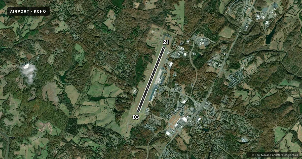
Runways & pattern
Full pagePattern entry · RWY 03
LEFT TRAFFICRunway end performance
| End | TORA | TODA | ASDA | LDA | VGSI | Approach lights | Obstruction |
|---|---|---|---|---|---|---|---|
| 03 | 6,801' | 6,801' | 6,801' | 6,801' | PAPI 4-box left(3°) | MALSR | — |
| 21 | 6,801' | 6,801' | 6,801' | 6,801' | PAPI 4-box right(3°) | — | — |
Declared distances in feet. TORA = takeoff run available, TODA = takeoff distance, ASDA = accelerate-stop, LDA = landing distance.
Airport sketch
Runways drawn to scale from FAA survey coordinates, rendered over satellite imagery. Not for navigation.
Approaches & charts
ILS · 1
Services on the field
Fuel grades, oxygen, maintenance, ramp storage and lighting — as declared to the FAA by the airport operator.
Fuel & services
- Fuel
- 100LLA
- Oxygen (bottled)
- Not available
- Oxygen (bulk)
- Not available
- Airframe repair
- Major
- Power plant repair
- Major
- Other services
- CHTR,INSTR,RNTL
Ramp & ground
- Transient storage
- Tie-down
- Hangar
- Landing fee
- Yes
- Customs
- Not available
- Lighting schedule
- SEE RMK
- Beacon schedule
- SS-SR
- Beacon
- White / Green (civil land)(WG)
- Wind indicator
- Lighted
- Segmented circle
- Yes
Fuel & FBOs
Cheapest 100LL and Jet A on the field and nearby. Always confirm with the FBO before taxi.
Airport notes
Surface conditions, obstructions, local procedures, lighting outages and other notes published with each FAA cycle.
General notes
- DEER & BIRDS ON & INVOF ARPT.
- FOR CD WHEN ATCT IS CLSD CTC POTOMAC APCH AT 866-640-4124.
- FOR ACFT SVCS CTC 126.925.
Lighting notes
- WHEN ATCT CLSD HIRL RWY 03/21, & TWY LIGHTS PRESET LOW INTST. TO ACTVT & INCREASE INTST MALSR RWY 03; REIL RWY 21; HIRL RWY 03/21 & TWY LIGHTS - CTAF.
Runway surface & condition
- 03/21PCR VALUE: 360/F/D/X/T
Approach & departure obstructions
- 21+7 FT OBST LGTD EQPT BOX RACK 78 FT FM AER, 250 FT L.
- 21UNUSBL BYD 6.5 DEG L OF RCL.
Other notes
- EXISTED PRIOR TO 1959.
- PPR 24 HRS FOR UNSKED AIR CARRIER OPS WITH MORE THAN 30 PSGR SEATS, 24 HR PPR FOR ALL FIXED WING MIL AIRCRAFT RON, CALL AMGR AT 434-981-4152.
- LNDG FEE ONLY FOR ACFT OVER 7000 LBS.
- MANAGERX104.
VFR map & nearby airports
VFR sectional. Tap any ICAO chip to open that airport.
Key facts · KCHO
Answer card- ICAO
- KCHO
- Name
- CHARLOTTESVILLE-ALBEMARLE
- Location
- CHARLOTTESVILLE, VIRGINIA
- Elevation
- 640.1 ft MSL
- Traffic pattern altitude
- 1,640.1 ft MSL (1,000 AGL)
- Control tower
- Towered · 0600-2300
- Total runways
- 1
- Longest runway
- 03/21 · 6,801 ft
- Published ILS approaches
- 1
- Published frequencies
- 12
- Magnetic variation
- 8°
- Current flight rules
- VFR
- Current wind
- 340° at 4 kt
- Favored runway now
- RWY 03
Charlottesville-Albemarle Airport sits in Charlottesville, Virginia. The field elevation is 640.1 ft MSL. It has one asphalt runway, 03/21, which is 6,801 ft long. The control tower is open from 0600 to 2300. Runway 03 has the ILS approach. Pattern altitude is not published, so use the standard 1,000 ft AGL for light piston operations unless the current Chart Supplement says otherwise.
Signature Aviation is on the field. It carries 100LL and Jet A. If you need fuel or ramp details, call them directly before arrival. When the tower is closed, the runway and taxiway lights are preset to low intensity. Use the CTAF to bring up the MALSR for runway 03. Use it for the REIL on runway 21 too. That matters after hours.
A few remarks matter for planning. Runway 21 is unusable beyond 6.5 degrees left of centerline. There is also a lighted equipment box rack near the runway 21 end. Deer and birds are reported on and near the airport. For clearance delivery when the tower is closed, contact Potomac Approach. This is a busy controlled field, so get current airspace and any local procedures from the current FAA Chart Supplement before you go.