METAR & TAF KCEF
Current METAR
Observed 16:55Z
KCEF 271655Z 00000KT 10SM FEW050 FEW250 28/15 A2978 RMK AO2A LTG DSNT W SLP087 T02780154
- Wind
- 000° @ 0 kt
- Visibility
- 10 SM
- Temp / Dew
- 28°C / 15°C
- Altimeter
- 29.78 inHg
- Clouds
- FEW
- Density alt
- 2,033 ft
- Ceiling
- Unlimited
- Rules
- VFR
Airport info & contacts
Manager on record, flight service, ARTCC, attendance schedule and pattern altitude — published by the FAA and refreshed every 28 days.
Location
- From city
- 3 NM NE
- VFR sectional
- NEW YORK
- ARTCC
- ZBW · BOSTON
- NOTAM facility
- CEF (NOTAM-D)
Airport manager
- Name
- ANDY WIDOR
- Phone
- 413-593-5543
- Address
- WESTOVER METRO ARPT, 255 PADGETTE ST, CHICOPEE MA 01022
Flight service · Hours
- FSS BTV
- BURLINGTON1-800-WX-BRIEF
- Attendance
- MON-FRI · 0800-2300
- SAT · 0900-1700
- SUN · 1300-2100
Frequencies
Tap any row to copy the frequency to your clipboard.
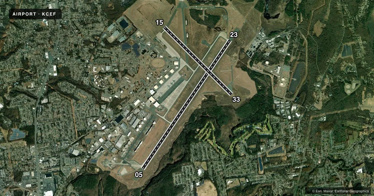
Runways & pattern
Full pagePattern entry · RWY 05
RIGHT TRAFFIC| Runway | Heading (°M) | Length | Surface | Traffic |
|---|---|---|---|---|
| 05/23 | 20° / 200° | 11,597 ft | ASPH | 05 R |
| 15/33 | 121° / 301° | 7,085 ft | ASPH | 33 R |
Runway end performance
| End | TORA | TODA | ASDA | LDA | VGSI | Approach lights | Obstruction |
|---|---|---|---|---|---|---|---|
| 05 | — | — | — | — | PAPI 4-box left(3°) | ALSF1 | — |
| 23 | — | — | — | — | PAPI 4-box left(3°) | ALSF1 | — |
| 15 | — | — | — | — | PAPI 4-box left(3°) | — | — |
| 33 | — | — | — | — | PAPI 4-box left(3°) | — | — |
Declared distances in feet. TORA = takeoff run available, TODA = takeoff distance, ASDA = accelerate-stop, LDA = landing distance.
Airport sketch
Runways drawn to scale from FAA survey coordinates, rendered over satellite imagery. Not for navigation.
Approaches & charts
ILS · 2
Services on the field
Fuel grades, oxygen, maintenance, ramp storage and lighting — as declared to the FAA by the airport operator.
Fuel & services
- Fuel
- 100LLA
- Other services
- CHTR
Ramp & ground
- Transient storage
- Tie-down
- Hangar
- Landing fee
- Yes
- Lighting schedule
- SEE RMK
- Beacon schedule
- SEE RMK
- Beacon
- Split White / Green (military)(SWG)
- Wind indicator
- Yes
- Segmented circle
- No
Fuel & FBOs
Cheapest 100LL and Jet A on the field and nearby. Always confirm with the FBO before taxi.
Airport notes
Surface conditions, obstructions, local procedures, lighting outages and other notes published with each FAA cycle.
General notes
- CIV TRNG LTD TO LOW APCH ONLY; TGL NOT AUTH.
- CEF IS A JOINT-USE AFLD. IFR TKOF & LDG MIN AS PRESCRIBED BY USAF REG APPLY.
- HVY VFR TFC BELOW 10,000 FT ALONG RIVER & HWY 5 NM SW OF AFLD.
- PAPI ALL RWYS PRVD PROPER TCH FOR HGT GP4 ACFT ONLY.
- LGT: PAPI OFF DUR OPR HR PERIODS OF NO TFC.
- RSTD: AFT HRS DEP/ARR 24 HR PPR NOTICE 413-593-5543.
- CAUTION: VMC DEP ACFT REMAIN AT OR BLW 1000 FT TIL PAST DEP END OF RWY TO ENSURE SEPARATION FM VFR OVERHEAD & CLSD PAT TFC. STROBE LGT LCTD ATOP STACKS 4000 FT LEFT RWY 23 THR; OCCASIONAL STEAM CLOUD. UNCTLD VEH TFC ON RAMPS & TWY.
- CAUTION: LGT ACFT TFC, HANG GLIDER OPR AND HOT AIR BALLOON ACT ALONG RIVER W AND NW OF ARPT. EXTV HANG GLIDER & GLIDER IN THE MT GREYLOCK AREA APRX 45 NM NW OF AFLD. UNLGTD OBST W SIDE RWY 05 CLEAR ZONE.
- CUST: PILOT MUST ARNG CUST 860-292-1314.
- CAUTION: POTENTIAL FOR HYDROPLANING AFTER ANY PRECIPITATION. PONDING AT INT RY 05/23 & 15/33 MEASURED IN 1/10TH INCHES; SEE NOTAMS FOR KCEF.
- MILITARY: RSTD: CIV PILOTS ARE REMINDED TO CHECK MIL NOTAMS BY VISITING THE FEDERAL NOTAM SYSTEM (FNS) WEBSITE (HTTPS://NOTAMS.AIM.FAA.GOV/NOTAMSEARCH/) OR CONTACTING FLIGHT SERVICE.
- TRANS ALERT: FLEET SVC FOR TRAN ACFT UNAVBL WKEND AND M-F 2030-0400Z++ WITHOUT PRIOR APVL FR AMOPS DSN 589-2951.
- CAUTION: EASTSIDE PAD 19, PAD 33 AND TWY L DO NOT HAVE PAVED SHOULDERS.
- WHEN ATCT CLSD, FOR CD CTC BRADLEY APCH 860-386-3597.
- MILITARY: ACFT ON A JA/ATT, JCS, TACTICAL EXER, MIL CHTR MISSION CTC 439 LRS/LGRDX DSN 589-3318/3125 TO COORD SUPPORT RQMNTS. LGRDX WILL ARNG ALL RQRD SUPPORT. SAAM MISSIONS CDN WILL BE MADE WITH AIRFIELD MGR DSN 589-2944.
- PCL ONLY AUTH WITH 5 HR PPR TO FBO.
- RWY 15 WIND DATA EST AVBL AT ALL TIMES.
- ASSAULT STRIP MRK PAINTED 3000 FT X 60 FT ON RWY 15-33.
- RSTD: PPR DSN 589-2951, C413-557-2951.
- MISC: FIRST 1000 FT EACH END RWY 05-23 CONC AND MID 9597 FT IS ASPH.
Lighting notes
- CLEAR SIDE IS SPLIT. DALGT TURNED ON WHEN AIRFIELD IS IFR.
- DUSK-2300. AIRFIELD LGTS NOT AVBL 2300-0700 HRS.
- WHEN ATCT CLSD ACTVT ALSF1 RWY 05 & 23; PAPI RWY 5, 15, 23 & 33; HIRL RWY 05/23 & 15/33 - CTAF.
Fuel notes
- 100LLFUEL OPR HRS 1200-0400Z++ WKDAYS, 1400-2200Z++ SAT, 1800-0200Z++ SUN. UTA HRS 1200-2100Z++ SAT-SUN. IF FUEL SUPPORT IS NEEDED OUTSIDE THESE HOURS ON UTA, REQ APVL THRU AMOPS WHEN ACUIRING PPR, EXC HOL.
Runway surface & condition
- 05/231000 FT OVRN BOTH ENDS OF RWY.
Approach & departure obstructions
- 05ALSF-1 SFL PTN OTS UFN.
- 15NO RVR AVBL.
- 23PAPI UNUSBL BYD 6 DEGS R.
Other notes
- RECTANGULAR TFC PAT: 1000 FT AGL LGT ACFT, 2000 FT AGL LRG/HVY ACFT; OVHD: 2500 FT AGL.
- MANAGERCTC AMGR FOR CIV OPS ANDY WIDOR AT A.WIDOR@WESTOVERAIRPORT.COM.
- OWNERCIV PTN OF THE ARPT (TWY A, P & S) IS OWNED BY WESTOVER METRO DEV CORP, 255 PADGETTE ST, CHICOPEE MA 01020.
VFR map & nearby airports
VFR sectional. Tap any ICAO chip to open that airport.
Key facts · KCEF
Answer card- ICAO
- KCEF
- Name
- WESTOVER ARB/METRO
- Location
- SPRINGFIELD/CHICOPEE, MASSACHUSETTS
- Elevation
- 241.1 ft MSL
- Traffic pattern altitude
- 1,241.1 ft MSL (1,000 AGL)
- Control tower
- Towered · 0700-2300
- Total runways
- 2
- Longest runway
- 05/23 · 11,597 ft
- Published ILS approaches
- 2
- Published frequencies
- 13
- Magnetic variation
- 14°
- Current flight rules
- VFR
- Current wind
- 000° at 0 kt
- Favored runway now
- –
Westover ARB/Metro sits in Springfield/Chicopee, Massachusetts. Field elevation is 241.1 ft MSL. The airport has 2 asphalt runways. The longest is 11,597 ft on 05/23. Tower service is published from 0700 to 2300. Two ILS approaches are available, both on runway ends 05 and 23.
Pattern altitude is published at 1,000 ft AGL for light aircraft. Large and heavy aircraft use 2,000 ft AGL. Overhead is 2,500 ft AGL. This is a joint-use airfield, so military traffic and military NOTAMs matter here. The remarks also call out IFR takeoff and landing minimums under United States Air Force regulations. That is not a normal civilian-only setup. Check the current FAA Chart Supplement and current NOTAMs before you go.
Metro Air Services is on the field. It carries 100LL, Jet A and Jet A Prist. When the tower is closed, clearance delivery goes through Bradley Approach. The remarks also note a beacon schedule from dusk to 2300. Airfield lights are not available from 2300 to 0700. There is also a caution about heavy VFR traffic below 10,000 ft along the river and highway southwest of the airfield. Expect a busy environment and watch for ramp and taxiway vehicle traffic.