METAR & TAF KBUF
Current METAR
Observed 14:54Z
KBUF 271454Z 21009KT 10SM FEW016 FEW110 FEW170 FEW250 24/20 A2985 RMK AO2 SLP103 FU ALF T02440200 50000 $
- Wind
- 210° @ 9 kt
- Visibility
- 10 SM
- Temp / Dew
- 24°C / 20°C
- Altimeter
- 29.85 inHg
- Clouds
- FEW
- Density alt
- 2,068 ft
- Ceiling
- Unlimited
- Rules
- VFR
Airport info & contacts
Manager on record, flight service, ARTCC, attendance schedule and pattern altitude — published by the FAA and refreshed every 28 days.
Location
- From city
- 5 NM E
- VFR sectional
- DETROIT
- ARTCC
- ZOB · CLEVELAND
- NOTAM facility
- BUF (NOTAM-D)
Airport manager
- Name
- LEE WEITZ
- Phone
- (716) 630-6030
- Address
- 4200 GENESEE ST, BUFFALO NY 14225
Flight service · Hours
- FSS BUF
- BUFFALO1-800-WX-BRIEF
- Attendance
- ALL
Frequencies
Tap any row to copy the frequency to your clipboard.
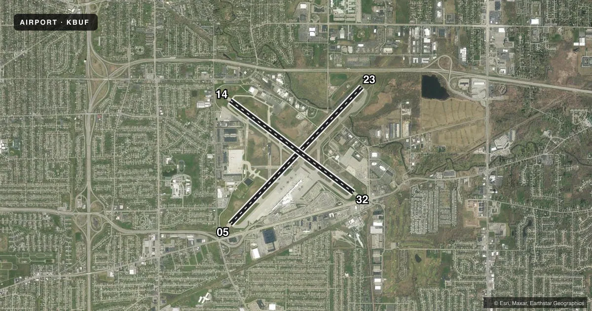
Runways & pattern
Full pagePattern entry · RWY 23
LEFT TRAFFIC| Runway | Heading (°M) | Length | Surface | Traffic |
|---|---|---|---|---|
| 05/23Favored | 33° / 213° | 8,829 ft | ASPH | Standard L |
| 14/32 | 116° / 296° | 7,161 ft | ASPH | Standard L |
Runway end performance
| End | TORA | TODA | ASDA | LDA | VGSI | Approach lights | Obstruction |
|---|---|---|---|---|---|---|---|
| 05 | 8,829' | 8,829' | 8,104' | 7,569' | PAPI 4-box left(3°) | MALSR | 21', bldg, 413' from thr, 532' R of cntrln, slope 10 |
| 23 | 8,829' | 8,829' | 8,294' | 7,569' | PAPI 4-box right(3°) | ALSF2 | 29', tree, 1155' from thr, 360' R of cntrln, slope 32 |
| 14 | 7,161' | 7,161' | 6,441' | 6,121' | PAPI 4-box left(3°) | — | 31', tree, 608' from thr, 535' R of cntrln, slope 13 |
| 32 | 7,161' | 7,161' | 6,841' | 6,121' | PAPI 4-box left(3°) | MALSR | 14', sign, 200' from thr, 429' R of cntrln, slope 1 |
Declared distances in feet. TORA = takeoff run available, TODA = takeoff distance, ASDA = accelerate-stop, LDA = landing distance.
Airport sketch
Runways drawn to scale from FAA survey coordinates, rendered over satellite imagery. Not for navigation.
Approaches & charts
ILS · 3
Services on the field
Fuel grades, oxygen, maintenance, ramp storage and lighting — as declared to the FAA by the airport operator.
Fuel & services
- Fuel
- 100LLA
- Oxygen (bottled)
- HIGH/LOW
- Oxygen (bulk)
- HIGH/LOW
- Airframe repair
- Major
- Power plant repair
- Major
- Other services
- AFRT,AMB,AVNCS,CARGO,CHTR,INSTR,RNTL,SALES,SURV
Ramp & ground
- Transient storage
- Tie-down
- Hangar
- Landing fee
- Yes
- Customs
- Not available
- Beacon schedule
- SS-SR
- Beacon
- White / Green (civil land)(WG)
- Wind indicator
- Lighted
- Segmented circle
- No
Fuel & FBOs
Cheapest 100LL and Jet A on the field and nearby. Always confirm with the FBO before taxi.
Airport notes
Surface conditions, obstructions, local procedures, lighting outages and other notes published with each FAA cycle.
General notes
- HEAVY CONCENTRATION OF GULLS; BLACKBIRDS & STARLINGS UP TO 5000 FT ON & INVOF ARPT.
- DEER ON & INVOF ARPT.
- FOR FBO SVCS CTC 131.75; FOR CARGO SVCS CTC 122.95.
- TWY A SW RUNUP AREA/HLDG BAY MKD DESIGN GROUP 3 ACFT (GENERALLY B737 A321 OR SMALLER) UNAVBL DESIGN GROUP 4 (INCL BUT NOT LTD TO B757 767).
- TWY 'K1' CLSD 2100-0800 DAILY.
- TWY P BTN APCH END RWY 14 AND TWY P2 CLSD TO ACFT WINGSPAN MORE THAN 117 FT.
Runway surface & condition
- 05/23PCR VALUE: 2110/F/B/X/T
- 14/32PCR VALUE: 900/F/D/X/T
Approach & departure obstructions
- 05RWY 05 HAS +3 FT POLE LIGHT POLE 59 FT FM RWY END, 497 FT RIGHT.
- 32+7 FT OBSTRUCTION LIGHTED FENCE , 0 FT FM RWY END, 480 FT LEFT.
- 05RWY 05 APCH SLOPE 45:1 TO DSPLCD THLD.
- 14RWY 14 APCH SLOPE 29:1 TO DSPLCD THLD.
Other notes
- EXISTED PRIOR TO 1959.
- ARFF INDEX D EQUIPMENT COVERAGE PROVIDED.
VFR map & nearby airports
VFR sectional. Tap any ICAO chip to open that airport.
Key facts · KBUF
Answer card- ICAO
- KBUF
- Name
- BUFFALO NIAGARA INTL
- Location
- BUFFALO, NEW YORK
- Elevation
- 726.8 ft MSL
- Traffic pattern altitude
- 1,726.8 ft MSL (1,000 AGL)
- Control tower
- Towered · 24
- Total runways
- 2
- Longest runway
- 05/23 · 8,829 ft
- Published ILS approaches
- 3
- Published frequencies
- 17
- Magnetic variation
- 11°
- Current flight rules
- VFR
- Current wind
- 210° at 9 kt
- Favored runway now
- RWY 23
Buffalo Niagara Intl is in Buffalo, New York. Field elevation is 726.8 ft MSL. The airport has 2 asphalt runways. The longest is 8,829 ft on 05/23. The tower is open 24 hours. Three ILS approaches are published for runway ends 05, 23 and 32. Pattern altitude is not published, so verify the current Chart Supplement before you fly. For light piston traffic, use the standard 1,000 ft AGL unless local guidance says otherwise.
Signature Aviation is on the field. It carries 100LL and Jet A. Call (716) 633-1000 for current service details. The airport sits in a busy Class C environment. Expect normal ATC coordination on the way in and out. Published remarks call out a heavy bird presence. Gulls, blackbirds and starlings have been reported up to 5,000 ft in and around the airport. Deer are also noted on and near the field. That matters on departure and in the pattern.
There are a few ground notes worth planning for. Taxiway K1 is closed daily from 2100 to 0800. Taxiway P between the approach end of runway 14 and taxiway P2 is closed to aircraft with wingspan over 117 ft. Runway 05/23 and 14/32 both have published pavement strength data. Larger aircraft should check suitability before arrival.