METAR & TAF KBQR
KBQR does not publish a METAR.
Showing the nearest reporting station: KBUF (BUFFALO NIAGARA INTL) · 5.3 NM away. Conditions at KBQR may differ.
METAR · KBUF
Observed 15:54Z
KBUF 271554Z 20009KT 10SM FEW020 FEW120 FEW180 FEW250 26/19 A2984 RMK AO2 SLP100 FU ALF T02560194 $
- Wind
- 200° @ 9 kt
- Visibility
- 10 SM
- Temp / Dew
- 26°C / 19°C
- Altimeter
- 29.84 inHg
- Clouds
- FEW
- Density alt
- 2,351 ft
- Ceiling
- Unlimited
- Rules
- VFR
Airport info & contacts
Manager on record, flight service, ARTCC, attendance schedule and pattern altitude — published by the FAA and refreshed every 28 days.
Location
- From city
- 12 NM E
- VFR sectional
- DETROIT
- Pattern altitude
- 800 ft AGL · 1,552 ft MSL
- ARTCC
- ZOB · CLEVELAND
- NOTAM facility
- BUF (NOTAM-D)
Airport manager
- Name
- GEORGE EZZO
- Phone
- 716-860-6044
- Address
- DARIEN CENTER NY 14040-1922
Flight service · Hours
- FSS BUF
- BUFFALO1-800-WX-BRIEF
- Attendance
- ON CALL
Frequencies
Tap any row to copy the frequency to your clipboard.
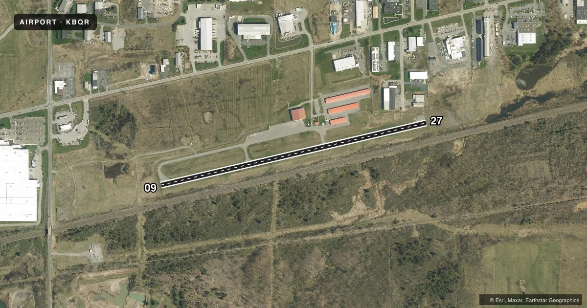
Runways & pattern
Full pagePattern entry · RWY 27
LEFT TRAFFICRunway end performance
| End | TORA | TODA | ASDA | LDA | VGSI | Approach lights | Obstruction |
|---|---|---|---|---|---|---|---|
| 09 | — | — | — | — | PAPI 2-box right(3°) | — | 23', rr, 201' from thr, 215' R of cntrln, slope 0 |
| 27 | — | — | — | — | PAPI 2-box left(3°) | — | 25', rr, 201' from thr, 215' R of cntrln, slope 0 |
Declared distances in feet. TORA = takeoff run available, TODA = takeoff distance, ASDA = accelerate-stop, LDA = landing distance.
Airport sketch
Runways drawn to scale from FAA survey coordinates, rendered over satellite imagery. Not for navigation.
Approaches & charts
Services on the field
Fuel grades, oxygen, maintenance, ramp storage and lighting — as declared to the FAA by the airport operator.
Fuel & services
- Fuel
- 100LL
- Oxygen (bottled)
- Not available
- Oxygen (bulk)
- Not available
- Airframe repair
- Major
- Power plant repair
- Major
- Other services
- AFRT,INSTR,RNTL
Ramp & ground
- Transient storage
- Tie-down
- Hangar
- Landing fee
- No fee published
- Customs
- Not available
- Lighting schedule
- SEE RMK
- Beacon schedule
- SS-SR
- Beacon
- White / Green (civil land)(WG)
- Wind indicator
- Lighted
- Segmented circle
- No
Fuel & FBOs
Cheapest 100LL and Jet A on the field and nearby. Always confirm with the FBO before taxi.
Airport notes
Surface conditions, obstructions, local procedures, lighting outages and other notes published with each FAA cycle.
General notes
- 25 FT RLRD; 215 FT S & PARL TO RWY.
- FOR CD CTC CLEVELAND ARTCC AT 440-774-0490.
Lighting notes
- ACTVT REILS RWY 09 & 27; PAPIS RWY 09 & 27; MIRLS RWY 9/27 - CTAF.
Approach & departure obstructions
- 099 FT FENCE, 15 FT TREE, 23 FT RR.
- 279 FT FENCE, 25 FT RR.
- 09RWY 09 PAPI UNUSBL BYD 3 DEG RT OF RCL.
- 27RWY 27 PAPI UNUSBL BYD 5 DEG LEFT OF RCL.
- 099 FT FENCE, 15 FT TREES.
Other notes
- VFR OPS ONLY.
- AUTOMATED UNICOM. ADZY ALSO AVBL BY CALLING 617-262-3825.
- 1716-860-6044.
- MANAGERALTN CTC: ERIC WOBSCHALL 716-208-5460 ERIC@BUFFALOLANCASTER.COM.
VFR map & nearby airports
VFR sectional. Tap any ICAO chip to open that airport.
Key facts · KBQR
Answer card- ICAO
- KBQR
- Name
- BUFFALO-LANCASTER RGNL
- Location
- BUFFALO, NEW YORK
- Elevation
- 751.7 ft MSL
- Traffic pattern altitude
- 1,551.7 ft MSL (800 AGL)
- Control tower
- Non-towered (use CTAF)
- Total runways
- 1
- Longest runway
- 09/27 · 3,199 ft
- Published ILS approaches
- 0
- Published frequencies
- 4
- Magnetic variation
- 10°
- Current flight rules
- VFR
- Current wind
- 200° at 9 kt
- Favored runway now
- RWY 27
Buffalo-Lancaster Regional Airport sits in Buffalo, New York. Field elevation is 751.7 ft MSL. The airport has one runway. Runway 09/27 is 3,199 ft long, which is the longest runway on the field. There is no control tower, so use CTAF 123.05 for local traffic and UNICOM. The published pattern altitude is 800 ft AGL, which is 1,551.7 ft MSL.
No ILS approaches are published here. This is a VFR-only airport, so plan accordingly. The field has runway end identifier lights, PAPIs on both runway ends and medium intensity runway lighting on 09/27. The runway 09 PAPI is unusable beyond 3 degrees right of centerline. The runway 27 PAPI is unusable beyond 5 degrees left of centerline. That matters on short final.
Buffalo-Lancaster Regional Airport is home to Buffalo-Lancaster Regional Airport, which carries AVGAS 100LL. Call the field at (716) 208-5460 for current fuel and ramp details. Published remarks also note a 25-foot railroad south and parallel to the runway. There are fence and tree obstructions near both runway ends. If you are new to the airport, brief the visual-only setup. Brief the short runway and the PAPI limits before you arrive.