METAR & TAF 9G0
9G0 does not publish a METAR.
Showing the nearest reporting station: KBUF (BUFFALO NIAGARA INTL) · 4.7 NM away. Conditions at 9G0 may differ.
METAR · KBUF
Observed 16:54Z
KBUF 271654Z 22007KT 10SM FEW023 26/19 A2984 RMK AO2 SLP100 FU ALF T02610189 $
- Wind
- 220° @ 7 kt
- Visibility
- 10 SM
- Temp / Dew
- 26°C / 19°C
- Altimeter
- 29.84 inHg
- Clouds
- FEW
- Density alt
- 2,250 ft
- Ceiling
- Unlimited
- Rules
- VFR
Airport info & contacts
Manager on record, flight service, ARTCC, attendance schedule and pattern altitude — published by the FAA and refreshed every 28 days.
Location
- From city
- 6 NM SE
- VFR sectional
- DETROIT
- Pattern altitude
- 830 ft AGL · 1,500 ft MSL
- ARTCC
- ZOB · CLEVELAND
- NOTAM facility
- BUF (NOTAM-D)
Airport manager
- Name
- JOSEPH R. PEZZANITE
- Phone
- 716-560-1836
- Address
- 4500 CLINTON ST, WEST SENECA NY 14224
Flight service · Hours
- FSS BUF
- BUFFALO1-800-WX-BRIEF
- Attendance
- ON CALL
Frequencies
Tap any row to copy the frequency to your clipboard.
Runways & pattern
Full pagePattern entry · RWY 24
LEFT TRAFFICRunway end performance
| End | TORA | TODA | ASDA | LDA | VGSI | Approach lights | Obstruction |
|---|---|---|---|---|---|---|---|
| 06 | — | — | — | — | PAPI 2-box right(3°) | — | 15', trees, 201' from thr, 32' R of cntrln, slope 0 |
| 24 | — | — | — | — | PAPI 2-box left(3°) | — | 19', trees, 201' from thr, 250' R of cntrln, slope 0 |
Declared distances in feet. TORA = takeoff run available, TODA = takeoff distance, ASDA = accelerate-stop, LDA = landing distance.
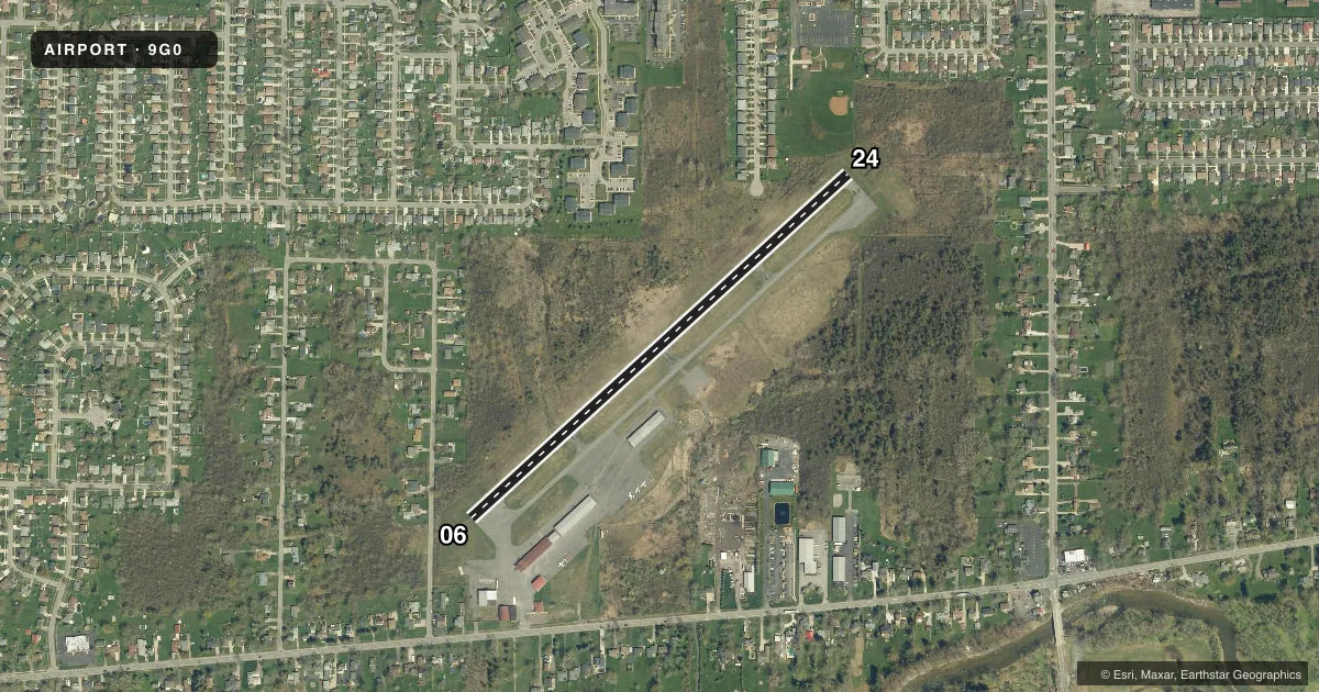
Airport sketch
Runways drawn to scale from FAA survey coordinates, rendered over satellite imagery. Not for navigation.
Approaches & charts
Services on the field
Fuel grades, oxygen, maintenance, ramp storage and lighting — as declared to the FAA by the airport operator.
Fuel & services
- Fuel
- 100LLA+
- Oxygen (bottled)
- Not available
- Oxygen (bulk)
- Not available
- Airframe repair
- Not available
- Power plant repair
- Not available
Ramp & ground
- Transient storage
- Tie-down
- Hangar
- Landing fee
- No fee published
- Customs
- Not available
- Lighting schedule
- SEE RMK
- Beacon schedule
- SS-SR
- Beacon
- White / Green (civil land)(WG)
- Wind indicator
- Lighted
- Segmented circle
- Yes
Fuel & FBOs
Cheapest 100LL and Jet A on the field and nearby. Always confirm with the FBO before taxi.
Airport notes
Surface conditions, obstructions, local procedures, lighting outages and other notes published with each FAA cycle.
General notes
- DEER ON & INVOF ARPT.
- RWY 6 & 24: NMRS TREES IN APCH.
- FOR CD CTC CLEVELAND ARTCC AT 440-774-0490.
- HOLD LINE MKGS POOR-NONE.
Lighting notes
- ACTVT REIL RWYS 06 & 24; MIRL RWY 06/24 - CTAF.
Fuel notes
- 100LL24 HRS SELF SVC FUEL.
Approach & departure obstructions
- 0640 FT TREES; UP TO 199 FT DSTC.
- 2415 FT TREES; UP TO 199 FT DSTC.
- 06CNTLG OBSTN EXCEEDS 45 DEG SLP.
Other notes
- EXISTED PRIOR TO 1959.
- 1CALL AMGR.
VFR map & nearby airports
VFR sectional. Tap any ICAO chip to open that airport.
Key facts · 9G0
Answer card- ICAO
- 9G0
- Name
- BUFFALO AIRFIELD
- Location
- BUFFALO, NEW YORK
- Elevation
- 669.6 ft MSL
- Traffic pattern altitude
- 1,499.6 ft MSL (830 AGL)
- Control tower
- Non-towered (use CTAF)
- Total runways
- 1
- Longest runway
- 06/24 · 2,666 ft
- Published ILS approaches
- 0
- Published frequencies
- 4
- Magnetic variation
- 11°
- Current flight rules
- VFR
- Current wind
- 220° at 7 kt
- Favored runway now
- RWY 24
Buffalo Airfield is in Buffalo, New York. The field elevation is 669.6 ft MSL. It has one runway, 06/24, which is 2,666 ft of asphalt. There is no control tower. Pattern altitude is 830 ft AGL, which is 1,499.6 ft MSL. No ILS approaches are published here.
Lindsay Aviation is on the field. It carries 100LL and Jet A Prist. Twenty-four hour self-serve fuel is available. For clearance delivery, contact Cleveland ARTCC at 440-774-0490. Runway lights on 06/24 are medium intensity and controlled by CTAF. Runway end identifier lights are also available on 06 and 24.
A first-time pilot should pay close attention on short final. The published remarks call out poor or missing hold line markings. Deer are on and near the airport. Trees are close in the approach area for both runway ends. The remarks also note obstructions near runway 06 and runway 24. Runway 06 has trees up to 199 ft from the threshold. Runway 24 has 15 ft trees up to 199 ft from the threshold. Check the current FAA Chart Supplement before you go for any updated operational notes.