METAR & TAF D51
D51 does not publish a METAR.
Showing the nearest reporting station: KBUF (BUFFALO NIAGARA INTL) · 7.9 NM away. Conditions at D51 may differ.
METAR · KBUF
Observed 13:54Z
KBUF 261354Z 25006KT 10SM FEW025 SCT100 SCT250 23/19 A2992 RMK AO2 SLP130 T02330189 $
- Wind
- 250° @ 6 kt
- Visibility
- 10 SM
- Temp / Dew
- 23°C / 19°C
- Altimeter
- 29.92 inHg
- Clouds
- SCT
- Density alt
- 1,690 ft
- Ceiling
- Unlimited
- Rules
- VFR
Airport info & contacts
Manager on record, flight service, ARTCC, attendance schedule and pattern altitude — published by the FAA and refreshed every 28 days.
Location
- From city
- 5 NM NE
- VFR sectional
- DETROIT
- ARTCC
- ZOB · CLEVELAND
- NOTAM facility
- BUF (NOTAM-D)
Airport manager
- Name
- FRED STANTON
- Phone
- 716-984-7905
- Address
- P.O.BOX 461, E. AMHERST NY 14051
Flight service · Hours
- FSS BUF
- BUFFALO1-800-WX-BRIEF
- Attendance
- Unattended
Frequencies
Tap any row to copy the frequency to your clipboard.
Runways & pattern
Full pagePattern entry · RWY 28
LEFT TRAFFICRunway end performance
| End | TORA | TODA | ASDA | LDA | VGSI | Approach lights | Obstruction |
|---|---|---|---|---|---|---|---|
| 10 | — | — | — | — | — | — | 90', trees, 0' from thr, 63' R of cntrln, slope 0 |
Declared distances in feet. TORA = takeoff run available, TODA = takeoff distance, ASDA = accelerate-stop, LDA = landing distance.
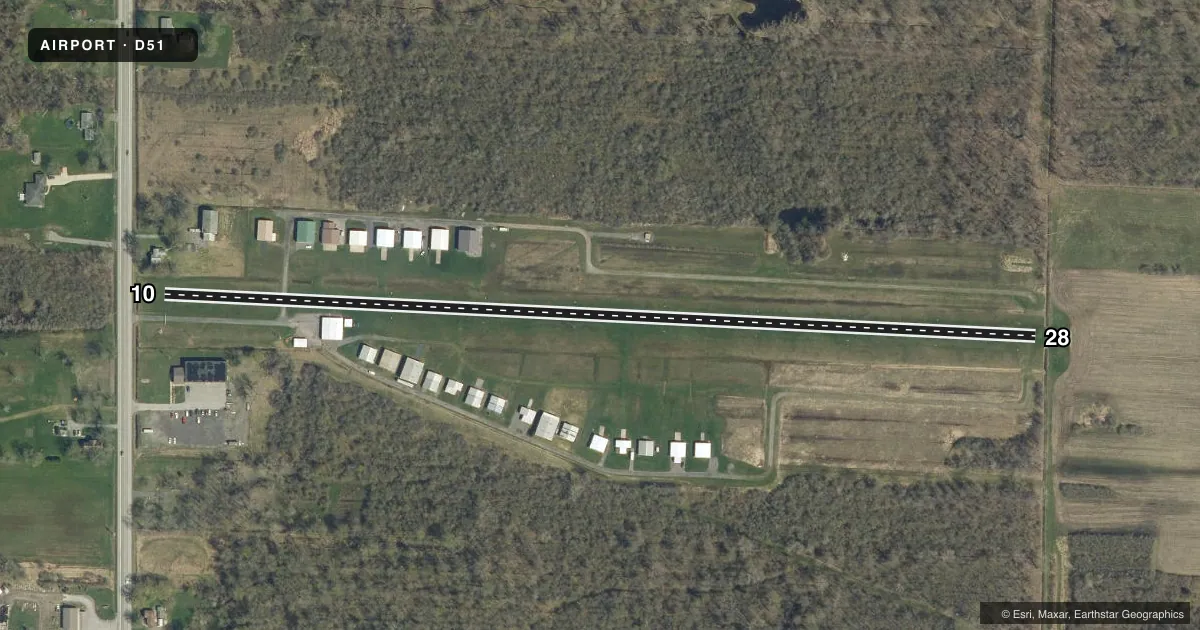
Airport sketch
Runways drawn to scale from FAA survey coordinates, rendered over satellite imagery. Not for navigation.
Approaches & charts
Services on the field
Fuel grades, oxygen, maintenance, ramp storage and lighting — as declared to the FAA by the airport operator.
Fuel & services
- Fuel
- Not available
Ramp & ground
- Transient storage
- Tie-down
- Landing fee
- No fee published
- Customs
- Not available
- Wind indicator
- Yes
- Segmented circle
- No
Fuel & FBOs
Cheapest 100LL and Jet A on the field and nearby. Always confirm with the FBO before taxi.
Airport notes
Surface conditions, obstructions, local procedures, lighting outages and other notes published with each FAA cycle.
General notes
- ULTRALGTS ON & INVOF ARPT.
- FOR CD CTC CLEVELAND ARTCC AT 440-774-0490.
- DEER & BIRDS ON AND INVOF ARPT.
- DRIVE/TWY CROSSES RWY 10 APX 300 FT FROM W END. RCMD TOUCHDOWN BYD TXY. 2200 FT RMNG.
Runway surface & condition
- 10/28FULL LEN NOT AVBL DUE TO ROUGH RWY SFC AT BOTH ENDS. NO MKGS ON RWY ENDS.
Approach & departure obstructions
- 1090 FT TREE AT RWY END, 63 FT L.
- 10RWY 10: 40 FT UNMKD P-LINE 157 FT DSTC, 145 L & R.
- 2840 FT MKD PLINE 1000 FT DSTC, 225 FT L & R.
Other notes
- OWNERRICH YORK, PRESIDENT; ROBERT DISPENZA; BOB BARRIE.
VFR map & nearby airports
VFR sectional. Tap any ICAO chip to open that airport.
Key facts · D51
Answer card- ICAO
- D51
- Name
- CLARENCE AERODROME
- Location
- BUFFALO, NEW YORK
- Elevation
- 589 ft MSL
- Traffic pattern altitude
- 1,589 ft MSL (1,000 AGL)
- Control tower
- Non-towered (use CTAF)
- Total runways
- 1
- Longest runway
- 10/28 · 2,500 ft
- Published ILS approaches
- 0
- Published frequencies
- 2
- Magnetic variation
- 10°
- Current flight rules
- VFR
- Current wind
- 250° at 6 kt
- Favored runway now
- RWY 28
Clarence Aerodrome (D51) sits near Buffalo, New York. Field elevation is 589 ft MSL. The airport has one runway. It is 10/28 and 2,500 ft long with a turf surface. The field is non-towered. CTAF and UNICOM are both 122.7. No ILS approaches are published here.
Pattern altitude is not published. For light piston operations, plan on the standard 1,000 ft AGL unless the current Chart Supplement says otherwise. Deer, birds and ultralights are reported on and near the airport. There is also a drive and taxiway crossing runway 10 about 300 ft from the west end. The published note recommends touchdown beyond that crossing. The runway surface is rough at both ends. The full length is not usable. Runway 10 also has a 90 ft tree near the end. Runway 28 has a marked power line about 1,000 ft from the threshold. There is also an unmarked power line near runway 10.
No on-field FBOs are listed. If you need fuel or local services, contact the airport operator directly before arrival. For IFR clearance delivery, the published remark gives Cleveland ARTCC at 440-774-0490. Check the current Chart Supplement for any noise or operational notes before you go.