METAR & TAF 9G3
9G3 does not publish a METAR.
Showing the nearest reporting station: KBUF (BUFFALO NIAGARA INTL) · 11.9 NM away. Conditions at 9G3 may differ.
METAR · KBUF
Observed 17:54Z
KBUF 271754Z 22010G16KT 10SM FEW030 FEW180 27/18 A2982 RMK AO2 SLP094 FU ALF T02670183 10272 20211 58009 $
- Wind
- 220° @ 10G16 kt
- Visibility
- 10 SM
- Temp / Dew
- 27°C / 18°C
- Altimeter
- 29.82 inHg
- Clouds
- FEW
- Density alt
- 2,605 ft
- Ceiling
- Unlimited
- Rules
- VFR
Airport info & contacts
Manager on record, flight service, ARTCC, attendance schedule and pattern altitude — published by the FAA and refreshed every 28 days.
Location
- From city
- 1 NM E
- VFR sectional
- DETROIT
- ARTCC
- ZOB · CLEVELAND
- NOTAM facility
- BUF (NOTAM-D)
Airport manager
- Name
- PETER TREICHLER
- Phone
- 716-542-4607
- Address
- BOX 126, JOHN ST., AKRON NY 14001
Flight service · Hours
- FSS BUF
- BUFFALO1-800-WX-BRIEF
- Attendance
- UNATND
Frequencies
Tap any row to copy the frequency to your clipboard.
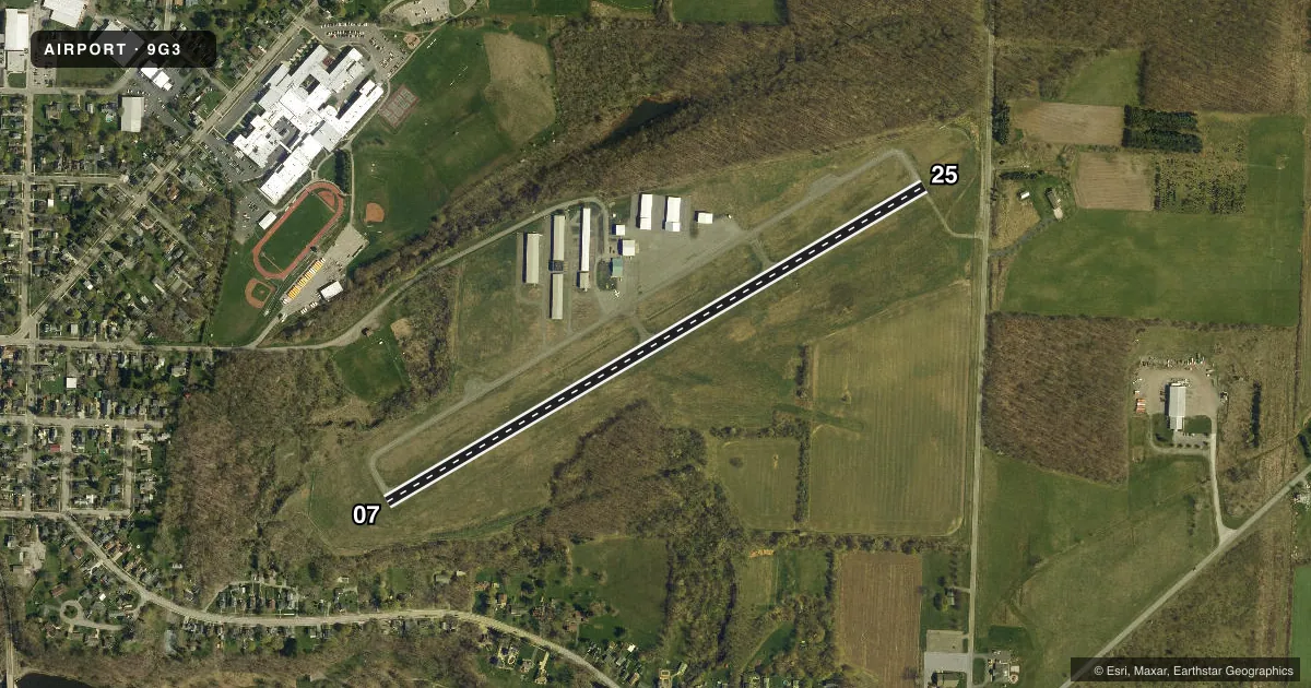
Runways & pattern
Full pagePattern entry · RWY 25
LEFT TRAFFICRunway end performance
| End | TORA | TODA | ASDA | LDA | VGSI | Approach lights | Obstruction |
|---|---|---|---|---|---|---|---|
| 07 | — | — | — | — | PAPI 2-box left(4°) | — | 50', trees, 201' from thr, 185' R of cntrln, slope 0 |
| 25 | — | — | — | — | PAPI 2-box left(4°) | — | 40', trees, 240' from thr, 240' R of cntrln, slope 1 |
Declared distances in feet. TORA = takeoff run available, TODA = takeoff distance, ASDA = accelerate-stop, LDA = landing distance.
Airport sketch
Runways drawn to scale from FAA survey coordinates, rendered over satellite imagery. Not for navigation.
Approaches & charts
Services on the field
Fuel grades, oxygen, maintenance, ramp storage and lighting — as declared to the FAA by the airport operator.
Fuel & services
- Fuel
- 100LL
- Oxygen (bottled)
- Not available
- Oxygen (bulk)
- Not available
- Airframe repair
- Not available
- Power plant repair
- Not available
- Other services
- INSTR,RNTL
Ramp & ground
- Transient storage
- Tie-down
- Landing fee
- No fee published
- Customs
- Not available
- Lighting schedule
- SEE RMK
- Beacon schedule
- SS-SR
- Beacon
- White / Green (civil land)(WG)
- Wind indicator
- Yes
- Segmented circle
- No
Fuel & FBOs
Cheapest 100LL and Jet A on the field and nearby. Always confirm with the FBO before taxi.
Airport notes
Surface conditions, obstructions, local procedures, lighting outages and other notes published with each FAA cycle.
General notes
- PARL TWY LGTD AND 35 FT WIDE.
- RWY 25 NOISE ABATEMENT - MNTN RWY HDG TIL 3/4 MI BYD DEP END RWY 25 BFR TURNING.
- FOR CD CTC CLEVELAND ARTCC AT 440-774-0490.
Lighting notes
- ACTVT PAPI RWY 07 & 25; REIL RWY 25; MIRL RWY 07/25 - CTAF.
Fuel notes
- 100LLFUEL 24 HR SELF SVC.
Approach & departure obstructions
- 078 FT FENCE: 54 FT DSTC, 220 FT R.
- 258 FT SIGN: 11 FT DSTC, 249 FT R; 8 FT FENCE 130-199 FT D.
- 07UNUSBL BYD 7 DEGS RIGHT OF CNTRLN.
- 07NMRS TREES IN THE APCH.
Other notes
- 1FOR ATNDTC CALL 716-864-5004, ALLEN KIDDER.
VFR map & nearby airports
VFR sectional. Tap any ICAO chip to open that airport.
Key facts · 9G3
Answer card- ICAO
- 9G3
- Name
- AKRON/JESSON FLD
- Location
- AKRON, NEW YORK
- Elevation
- 839.7 ft MSL
- Traffic pattern altitude
- 1,839.7 ft MSL (1,000 AGL)
- Control tower
- Non-towered (use CTAF)
- Total runways
- 1
- Longest runway
- 07/25 · 3,268 ft
- Published ILS approaches
- 0
- Published frequencies
- 4
- Magnetic variation
- 11°
- Current flight rules
- VFR
- Current wind
- 220° at 10 kt
- Favored runway now
- RWY 25
Akron/Jesson Fld sits in Akron, New York. Field elevation is 839.7 ft MSL. The airport has one asphalt runway, 07/25, at 3,268 ft. There is no control tower. CTAF and UNICOM are both 122.725. Buffalo handles approach and departure on 126.15 and 263.125. No ILS approaches are published here.
Pattern altitude is not published. Use 1,000 ft AGL for light piston operations unless the current Chart Supplement says otherwise. The field is set up for simple VFR work, but the published remarks matter. Runway 25 has a noise abatement note. Keep runway heading until three quarters of a mile beyond the departure end before turning. Runway 07 has approach limitations. There are also trees in the approach and fences near both runway ends, so plan your arrival and departure with that in mind.
Christian Airmen is on the field. It carries 100LL. Fuel is available 24 hours self-serve. For attendance, the published number is 716-864-5004 for Allen Kidder. The parallel taxiway is lighted and 35 feet wide. If you need clearance delivery, contact Cleveland ARTCC at 440-774-0490. This is a non-towered field. Standard self-announce discipline on CTAF is important.