METAR & TAF KBFI
Current METAR
Observed 14:53Z
KBFI 271453Z 19006KT 10SM BKN026 OVC036 17/13 A3009 RMK AO2 SLP187 T01720128 53005
- Wind
- 190° @ 6 kt
- Visibility
- 10 SM
- Temp / Dew
- 17°C / 13°C
- Altimeter
- 30.09 inHg
- Clouds
- OVC
- Density alt
- 56 ft
- Ceiling
- 2,600 ft AGL
- Rules
- MVFR
Airport info & contacts
Manager on record, flight service, ARTCC, attendance schedule and pattern altitude — published by the FAA and refreshed every 28 days.
Location
- From city
- 4 NM S
- VFR sectional
- SEATTLE
- ARTCC
- ZSE · SEATTLE
- NOTAM facility
- BFI (NOTAM-D)
Airport manager
- Name
- JOHN PARROTT, AAE
- Phone
- 206-296-7334
- Address
- 7277 PERIMETER ROAD SOUTH, SEATTLE WA 98108-3844
Flight service · Hours
- FSS SEA
- SEATTLE1-800-WX-BRIEF
- Attendance
- ALL
Frequencies
Tap any row to copy the frequency to your clipboard.
Runways & pattern
Full pagePattern entry · RWY 14R
RIGHT TRAFFIC| Runway | Heading (°M) | Length | Surface | Traffic |
|---|---|---|---|---|
| 14R/32LFavored | 135° / 315° | 10,007 ft | ASPH | 14R R |
| 14L/32R | 135° / 315° | 3,709 ft | ASPH | 32R R |
Runway end performance
| End | TORA | TODA | ASDA | LDA | VGSI | Approach lights | Obstruction |
|---|---|---|---|---|---|---|---|
| 14R | 10,000' | 10,000' | 9,120' | 9,120' | PAPI 4-box left(3°) | MALSF | 12', fence, 240' from thr, 425' R of cntrln, slope 3 |
| 32L | 10,000' | 10,000' | 10,000' | 9,120' | PAPI 4-box left(3.1°) | — | 27', rr, 200' from thr, 375' R of cntrln, slope 40 |
| 14L | — | — | — | — | PAPI 2-box left(3°) | — | — |
| 32R | — | — | — | — | PAPI 2-box left(3°) | — | 210', tree, 5000' from thr, 625' R of cntrln, slope 22 |
Declared distances in feet. TORA = takeoff run available, TODA = takeoff distance, ASDA = accelerate-stop, LDA = landing distance.
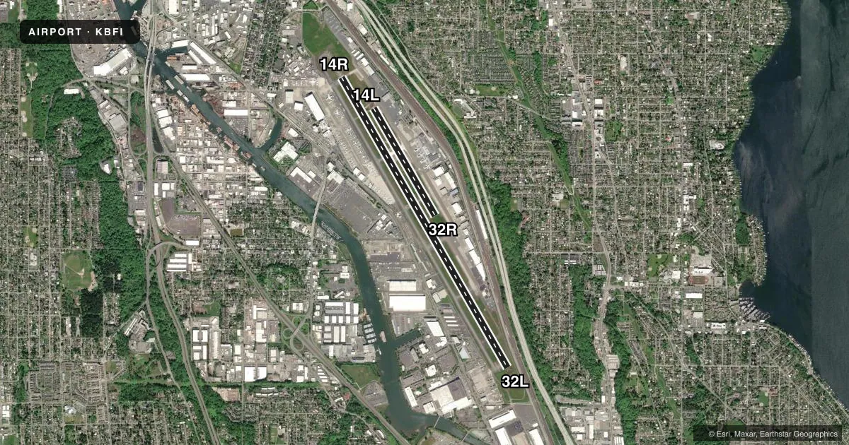
Airport sketch
Runways drawn to scale from FAA survey coordinates, rendered over satellite imagery. Not for navigation.
Approaches & charts
ILS · 2
Services on the field
Fuel grades, oxygen, maintenance, ramp storage and lighting — as declared to the FAA by the airport operator.
Fuel & services
- Fuel
- 100LLA
- Oxygen (bottled)
- HIGH/LOW
- Oxygen (bulk)
- HIGH/LOW
- Airframe repair
- Major
- Power plant repair
- Major
- Other services
- AFRT,AMB,AVNCS,CARGO,CHTR,INSTR,RNTL,SALES,SURV
Ramp & ground
- Transient storage
- Tie-down
- Hangar
- Landing fee
- Yes
- Customs
- Available
- Lighting schedule
- SEE RMK
- Beacon schedule
- SS-SR
- Beacon
- White / Green (civil land)(WG)
- Wind indicator
- Lighted
- Segmented circle
- No
Fuel & FBOs
Cheapest 100LL and Jet A on the field and nearby. Always confirm with the FBO before taxi.
Airport notes
Surface conditions, obstructions, local procedures, lighting outages and other notes published with each FAA cycle.
General notes
- TPA RWY 14L/32R 1000 MSL; RWY 14R/32L 800 MSL.
- TOUCH AND GO LNDGS PROHIBITED 2200-0700.
- BIRD FLOCKS WITHIN ARPT VICINITY. - CHECK LOCAL ADVISORIES.
- FLIGHT NOTIFICATION SERVICE (ADCUS) AVBL.
- 14' ANT (MKD/LGTD) 230' FM RY 14L END 125' R.
- TWY A1 & TWY A FROM A1-A3 RSTRD TO ACFT UP TO 150000 LBS AND LESS THAN 108 FT WINGSPAN.
- TWYS A2; A4: A6; &B2 RSTD TO ACFT UP TO 12500 LBS. TWY A9 RSTD TO ACFT UP TO 60000LBS.
- GA ITNRNT/TSNT PRKG AVBL. CTC ARPT OPS 206-296-7334.
- TWR 80 FT AGL LCTD 1200 FT N AND 900 FT W OF THLD RY 14R.
- FOR NOISE ABATEMENT PROCEDURES, CONTACT NOISE OFFICE AT (206) 296-7334.
- EXTENSIVE HELICOPTER TRAINING ACTIVITY ON TAXIWAY B.
- FOR MUSEUM OF FLT TSNT ACFT PRKG, PPR, CALL MUSEUM OF FLT SCTY (206) 920-9770.
- TAXIWAY ZULU AND 880' SPECIAL USE PAVEMENT AVAILABLE 72 HOURS PRIOR PERMISSION REQUIRED. CONTACT AIRPORT OPERATIONS 206-296-7334.
- EMERG FREQ 121.5 NOT MNT AT TWR.
- FOR BOEING MILITARY FLIGHT CENTER RAMP PERMISSION, CTC RAMP COORDINATOR 206-225-0989, 72 HOUR PRIOR PERMISSION REQUIRED, 96 HOUR PRIOR PERMISSION REQUIRED IF ORDNANCES/MUNITIONS INSTALLED OR IF ORDNANCES/MUNITIONS STORAGE IS REQUIRED. LIMITED LOX SERVICE MEETING MIL-PRF-27210J, TYPE II AVAILABLE FOR MILITARY FLIGHT CENTER TRANSIENT AIRCRAFT, CONTACT 96 HOURS PRIOR WITH NEEDED VOLUME AND AIRCRAFT TYPE. PRIOR TO ARRIVAL ONTO BOEING COMMERCIAL AIRPLANE RAMP, CTC BOEING SEATTLE AT 123.425 OR CALL 206-662-4500. ADVANCED PERMISSION TO ACCESS BOEING COMMERCIAL AIRPLANE RAMP ONLY, CTC 206-544-5900 M-F 1600Z-0000Z.
- FOR CD WHEN ATCT IS CLSD CTC SEATTLE APCH AT 206-214-4722.
- VFR PILOTS SHLD REVIEW & EXPC VFR PROCS PRIOR TO ARR/DEP.
Lighting notes
- HIRL RWY 14R/32L OPEN DUSK-DAWN. MIRL RWY 14L/32R NOT OPER 0600-1500Z++.
Runway surface & condition
- 14L/32RLTD TO USE BY ACFT UP TO 12,500 LBS.
- 14L/32RPCR VALUE: 310/F/B/X/T
- 14R/32LPCR VALUE: 770/R/C/W/T
- 14L/32RRWY 14L/32R NOT AVBL FOR PART 121/PART 380 OPS WITH SKED PAX CARRYING OPS MORE THAN 9 PAX SEATS AND NON-SKED PAX CARRYING OPS MORE THAN 30 PAX SEATS.
Approach & departure obstructions
- 32LFENCE/ROAD/POLES/RR TRACKS WITHIN EAST EDGE OF PRIM SFC.
- 32RUNUSBL BYD 4 DEGS RIGHT OF RWY CNTRLN.
- 32LAPCH SLOPE 40:1 TO DTHLD.
- 32RAPCH RATIO 27:1 FM DTHLD.
Other notes
- ESTABD PRIOR TO 1959.
- MANAGERJPARROTT@KINGCOUNTY.GOV.
VFR map & nearby airports
VFR sectional. Tap any ICAO chip to open that airport.
Key facts · KBFI
Answer card- ICAO
- KBFI
- Name
- BOEING FLD/KING COUNTY INTL
- Location
- SEATTLE, WASHINGTON
- Elevation
- 21.6 ft MSL
- Traffic pattern altitude
- 1,021.6 ft MSL (1,000 AGL)
- Control tower
- Towered · 24
- Total runways
- 2
- Longest runway
- 14R/32L · 10,007 ft
- Published ILS approaches
- 2
- Published frequencies
- 50
- Magnetic variation
- 15°
- Current flight rules
- MVFR
- Current wind
- 190° at 6 kt
- Favored runway now
- RWY 14R
KBFI sits in Seattle, Washington. Field elevation is 21.6 ft MSL. The airport has 2 asphalt runways. The longest is 10,007 ft on 14R/32L. The tower is open 24 hours. Two ILS approaches are published. They serve runway ends 14R and 32L.
Pattern altitude is not published in the facts for this field. The published remarks do give runway-specific values. Use 1,000 ft MSL for 14L/32R. Use 800 ft MSL for 14R/32L. That matters here because the two sides are not the same. Boeing Field is busy. Expect a lot of helicopter training on taxiway B. VFR pilots should review and expect VFR procedures before arrival and departure.
Three on-field FBOs are listed. Signature Aviation carries 100LL and Jet A. Skyservice carries 100LL, Jet A and Jet A Prist. Modern Aviation carries 100LL and Jet A. Taxiway A1 and taxiway A from A1 to A3 are restricted by weight and wingspan. Runway 32L also has nearby fence, road, poles and railroad tracks within the east edge of the primary surface. That is worth keeping in mind on final. General aviation transient parking is available. Contact airport operations before you go if you need a spot.