METAR & TAF KATL
Current METAR
Observed 11:52Z
KATL 271152Z 28008KT 7SM FEW050 FEW150 BKN200 OVC250 26/24 A2993 RMK AO2 SLP124 VIRGA OHD-ALQDS OCNL LTGICCG DSNT W-NW CB DSNT W-NW 70003 T02560244 10267 20250 53006
- Wind
- 280° @ 8 kt
- Visibility
- 7 SM
- Temp / Dew
- 26°C / 24°C
- Altimeter
- 29.93 inHg
- Clouds
- OVC
- Density alt
- 2,580 ft
- Ceiling
- 20,000 ft AGL
- Rules
- VFR
Airport info & contacts
Manager on record, flight service, ARTCC, attendance schedule and pattern altitude — published by the FAA and refreshed every 28 days.
Location
- From city
- 7 NM S
- VFR sectional
- ATLANTA
- ARTCC
- ZTL · ATLANTA
- NOTAM facility
- ATL (NOTAM-D)
Airport manager
- Name
- RICKY SMITH
- Phone
- 404-530-6600
- Address
- PO BOX 20509, ATLANTA GA 30320
Flight service · Hours
- FSS MCN
- MACON1-800-WX-BRIEF
- Attendance
- ALL
Frequencies
Tap any row to copy the frequency to your clipboard.
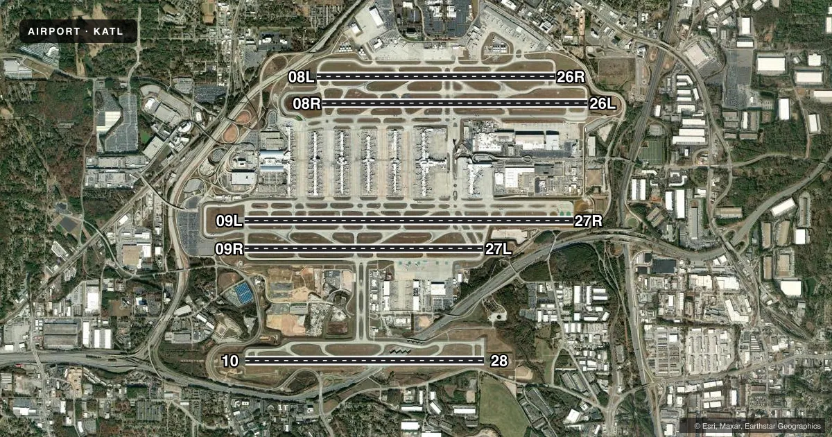
Runways & pattern
Full pagePattern entry · RWY 27R
LEFT TRAFFIC| Runway | Heading (°M) | Length | Surface | Traffic |
|---|---|---|---|---|
| 09L/27RFavored | 85° / 265° | 12,390 ft | CONC | Standard L |
| 08R/26L | 85° / 265° | 9,999 ft | CONC | Standard L |
| 10/28 | 85° / 265° | 9,000 ft | CONC | 10 R |
| 09R/27L | 85° / 265° | 9,000 ft | CONC | Standard L |
| 08L/26R | 85° / 265° | 9,000 ft | CONC | Standard L |
Runway end performance
| End | TORA | TODA | ASDA | LDA | VGSI | Approach lights | Obstruction |
|---|---|---|---|---|---|---|---|
| 09L | 12,390' | 12,390' | 11,730' | 11,730' | PAPI 4-box right(3°) | — | 110', tank, 3937' from thr, 214' R of cntrln, slope 33 |
| 27R | 12,390' | 12,390' | 12,390' | 11,890' | PAPI 4-box right(3°) | MALS | 62', tree, 2527' from thr, 388' R of cntrln, slope 37 |
| 08R | 9,999' | 10,999' | 9,999' | 9,999' | PAPI 4-box left(3°) | — | 94', tree, 2832' from thr, 557' R of cntrln, slope 28 |
| 26L | 9,999' | 9,999' | 9,999' | 9,999' | PAPI 4-box left(3°) | MALSR | 26', tree, 517' from thr, 496' R of cntrln, slope 12 |
| 10 | 9,000' | 9,000' | 9,000' | 9,000' | PAPI 4-box right(3°) | ALSF2 | 84', tree, 2820' from thr, 796' R of cntrln, slope 31 |
| 28 | 9,000' | 9,000' | 9,000' | 9,000' | PAPI 4-box right(3°) | ALSF2 | 136', tower, 4240' from thr, 410' R of cntrln, slope 30 |
| 09R | 9,000' | 9,000' | 9,000' | 9,000' | PAPI 4-box left(3°) | ALSF2 | 136', pole, 4497' from thr, 1012' R of cntrln, slope 31 |
| 27L | 9,000' | 9,000' | 8,865' | 8,865' | PAPI 4-box right(3°) | ALSF2 | 56', tree, 2259' from thr, 618' R of cntrln, slope 36 |
| 08L | 9,000' | 9,000' | 8,800' | 8,800' | PAPI 4-box left(3°) | ALSF2 | 116', tree, 3604' from thr, 661' R of cntrln, slope 29 |
| 26R | 9,000' | 9,000' | 8,500' | 8,500' | PAPI 4-box left(3°) | MALSR | 45', tree, 940' from thr, 581' R of cntrln, slope 16 |
Declared distances in feet. TORA = takeoff run available, TODA = takeoff distance, ASDA = accelerate-stop, LDA = landing distance.
Airport sketch
Runways drawn to scale from FAA survey coordinates, rendered over satellite imagery. Not for navigation.
Approaches & charts
ILS · 10
Services on the field
Fuel grades, oxygen, maintenance, ramp storage and lighting — as declared to the FAA by the airport operator.
Fuel & services
- Fuel
- 100100LLA
- Oxygen (bottled)
- HIGH/LOW
- Oxygen (bulk)
- HIGH/LOW
- Airframe repair
- Major
- Power plant repair
- Major
- Other services
- AMB,CARGO,CHTR
Ramp & ground
- Transient storage
- Hangar
- Landing fee
- Yes
- Customs
- Not available
- Beacon schedule
- SS-SR
- Beacon
- White / Green (civil land)(WG)
- Wind indicator
- Yes
- Segmented circle
- No
Fuel & FBOs
Cheapest 100LL and Jet A on the field and nearby. Always confirm with the FBO before taxi.
Airport notes
Surface conditions, obstructions, local procedures, lighting outages and other notes published with each FAA cycle.
General notes
- BE ALERT TO RWY CROSSING CLEARANCES. READBACK OF ALL RWY HOLDING INSTRUCTIONS IS REQUIRED.
- PREFERENTIAL RWY USE IN EFFECT, EXPECT TO USE RWYS 08R/26L, 09L/27R FOR DEPS; RWYS 08L/26R, 09R/27L ARE USED PRIMARILY FOR ARRIVALS.
- RUNUPS ARE PERMITTED AT VARIOUS SITES; COORD USE OF CITY FACS, MOVEMENT AREAS, ALLOWABLE NON-MOVEMENT AREAS WITH DEPT OF AVN OPNS, 404-787-6095; AND COORD THE USE OF THE AIRLINES FACS WITH THEM.
- NOISE & OPNS MONITORING SYSTEM (NOMS) PROGRAM IN EFFECT; CALL THE ATLANTA DEPT OF AVIATION 770-43-NOISE OR 770-436-6473 FOR MORE INFO.
- ALL RWYS, TOUCH AND GO OPERATIONS, LOW APPROACHES, AND PRACTICE INSTRUMENT APPROACHES NOT PERMITTED.
- ACFT WITH A WINGSPAN OF GREATER THAN 214FT ARE RESTRICTED FM USING TWY F EAST OF RAMP 5 NORTH AND WEST OF TWY D.
- ACFT WITH WINGSPAN GREATER THAN 171 FT ARE RSTRD FROM USING TWY V. ACFT WITH WINGSPAN GREATER THAN 171 FT ARE REQUIRED TO USE TAXI SPEEDS LESS THAN 15 MPH WHEN PASSING ACFT WITH WINGSPAN GREATER THAN 214FT ON TXWY L/M (EAST OF L7).
- RWY 9L DEPARTURES CAN EXPECT INTERSECTION DEPARTURE FM M2 WITH RWY REMAINING 11,440 FT (TORA/TODA) AND 10,780 (ASDA).
- ALL ACFT WITH WINGSPANS GREATER THAN 214 FT ARE REQUIRED TO USE TAXI SPEEDS NOT GREATER THAN 15 MPH ON TWYS A, L, M, AND SJ.
- WHEN ACFT WITH WINGSPANS GREATER THAN 214 FT ARE PRESENT ON THE FIELD, ALL OTHER ACFT MUST ADHERE TO THE TWY CENTERLINE ON TWYS L AND M, TWYS E AND F, AND TWYS SC AND SJ BETWEEN SG AND R DUE TO SEPARATION BETWEEN THE PARALLEL TWYS.
- TWO ACFT WITH WINGSPANS GREATER THAN 225 FT MAY NOT TAXI SIMULTANEOUSLY ON ADJACENT PARALLEL TWYS L/M EXCEPT WEST OF L7 AT SPEEDS LESS THAN 15 MPH. NO ACFT WITH WINGSPAN 226 FT OR GTR CAN TAXI ON TWY M BTN L14 AND L16, TWY N BTN P AND SC, OR TWY N BTN U AND K.
- NO ACFT WITH WINGSPAN GREATER THAN 213 FT MAY PASS ANOTHER ACFT WITH WINGSPAN GREATER THAN OR EQUAL TO 225 FT ON TWY L/M EAST OF L7.
- ACFT WITH WINGSPAN GTR THAN 171 FT AND/OR TAIL HGT GTR THAN 45 FT ARE RSTD FROM USING TWY W. DURG TWY W OPNS RWY 27R INTXN DEPS FROM TWY LB OR TWY LC CAN EXPC THE FLWG DSTCS WITH RWY RMNG: FROM TWY LB 11,040 FT (TORA/TODA) AND 12,140 FT (ASDA); FROM TWY LC 10,810 FT (TORA/TODA) AND 11,910 FT (ASDA). ACFT MAY REQ THE FULL LEN OF RWY 27R FOR DEP UPON INITIAL CTC WITH ATC.
- BIRD ACT ON AND INVOF ARPT.
- ACFT SHOULD NOT EXCT THE ACUTE ANGLED TWY TURN EBND TO NBND FROM TWY N TO TWY J.
- WHEN ACFT WITH WINGSPAN GREATER THAN OR EQUAL TO 172FT IS PRESENT ON TWY E BTN TWY E13 & APCH END RWY 26L, NO ACFT WITH WINGSPAN GREATER THAN OR EQUAL TO 144FT MAY BE PRESENT ON ECHO PAD.
Lighting notes
- ROTG BCN LCTD S OF TWY R7, N OF TWY SJ2 NR FIRE STATION.
Runway surface & condition
- 08L/26RPCR VALUE: 1437/R/D/W/T
- 08R/26LPCR VALUE: 1307/R/C/W/T
- 09L/27RPCR VALUE: 1336/R/C/W/T
- 09R/27LPCR VALUE: 1068/R/C/W/T
- 10/28PCR VALUE: 1378/R/C/W/T
Approach & departure obstructions
- 26LPAPI RWY 26L UNUSBL BYD 7 DEG LEFT AND RIGHT OF RCL.
- 26RPAPI RWY 26R UNUSBL BYD 6 DEG LEFT AND 7 DEG RIGHT OF RCL.
- 09LCONCRETE HOPPER
VFR map & nearby airports
VFR sectional. Tap any ICAO chip to open that airport.
Key facts · KATL
Answer card- ICAO
- KATL
- Name
- HARTSFIELD/JACKSON ATLANTA INTL
- Location
- ATLANTA, GEORGIA
- Elevation
- 1,026.2 ft MSL
- Traffic pattern altitude
- 2,026.2 ft MSL (1,000 AGL)
- Control tower
- Towered · 24
- Total runways
- 5
- Longest runway
- 09L/27R · 12,390 ft
- Published ILS approaches
- 10
- Published frequencies
- 27
- Magnetic variation
- 5°
- Current flight rules
- VFR
- Current wind
- 280° at 8 kt
- Favored runway now
- RWY 27R
Hartsfield/Jackson Atlanta Intl is in Atlanta, Georgia. Field elevation is 1,026.2 ft MSL. The airport has five runways. The longest is 12,390 ft. The tower is open 24 hours. Ten ILS approaches are published. Pattern altitude is not published, so use the standard 1,000 ft AGL pattern for light piston aircraft unless ATC says otherwise.
This is a busy Class B airport with heavy airline traffic. Expect preferential runway use. Departures usually favor 08R/26L and 09L/27R. Arrivals usually favor 08L/26R and 09R/27L. Runway 09L has a concrete hopper obstruction near it. Runway 09L departures can expect an intersection departure from M2 with reduced takeoff distance available. Touch-and-goes, low approaches and practice instrument approaches are prohibited on all runways.
Signature Aviation is on the field. It carries 100LL and Jet A. The airport also has published noise and operations monitoring. Check current procedures before arrival. Large aircraft have taxi restrictions on several taxiways, so plan ground movement carefully. If you are flying a piston single or light twin, expect a very controlled environment and stay ready for runway changes and taxi instructions from ATC.