METAR & TAF KAMA
Current METAR
Observed 19:53Z
KAMA 271953Z 15010KT 10SM CLR 39/11 A2997 RMK AO2 SLP076 T03890106
- Wind
- 150° @ 10 kt
- Visibility
- 10 SM
- Temp / Dew
- 39°C / 11°C
- Altimeter
- 29.97 inHg
- Clouds
- CLR
- Density alt
- 7,290 ft
- Ceiling
- Unlimited
- Rules
- VFR
Airport info & contacts
Manager on record, flight service, ARTCC, attendance schedule and pattern altitude — published by the FAA and refreshed every 28 days.
Location
- From city
- 7 NM E
- VFR sectional
- DALLAS-FT WORTH
- Pattern altitude
- 895 ft AGL · 4,502 ft MSL
- ARTCC
- ZAB · ALBUQUERQUE
- NOTAM facility
- AMA (NOTAM-D)
Airport manager
- Name
- MICHAEL CONNER
- Phone
- 806-335-1671
- Address
- 10801 ARPT BLVD, AMARILLO TX 79111
Flight service · Hours
- FSS FTW
- FORT WORTH1-800-WX-BRIEF
- Attendance
- ALL
Frequencies
Tap any row to copy the frequency to your clipboard.
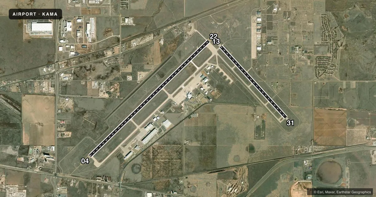
Runways & pattern
Full pagePattern entry · RWY 13
LEFT TRAFFIC| Runway | Heading (°M) | Length | Surface | Traffic |
|---|---|---|---|---|
| 04/22 | 38° / 218° | 13,502 ft | CONC | Standard L |
| 13/31Favored | 129° / 309° | 7,901 ft | CONC | Standard L |
Runway end performance
| End | TORA | TODA | ASDA | LDA | VGSI | Approach lights | Obstruction |
|---|---|---|---|---|---|---|---|
| 04 | 13,502' | 13,502' | 13,502' | 13,502' | PAPI 4-box left(3°) | MALSR | — |
| 22 | 13,502' | 13,502' | 13,502' | 13,502' | PAPI 4-box left(3°) | MALSR | — |
| 13 | 7,901' | 7,901' | 7,901' | 7,901' | PAPI 4-box left(3°) | — | — |
| 31 | 7,901' | 7,901' | 7,901' | 7,901' | PAPI 4-box left(3°) | — | — |
Declared distances in feet. TORA = takeoff run available, TODA = takeoff distance, ASDA = accelerate-stop, LDA = landing distance.
Airport sketch
Runways drawn to scale from FAA survey coordinates, rendered over satellite imagery. Not for navigation.
Approaches & charts
ILS · 2
Services on the field
Fuel grades, oxygen, maintenance, ramp storage and lighting — as declared to the FAA by the airport operator.
Fuel & services
- Fuel
- 100LLA1+
- Oxygen (bottled)
- Low pressure
- Oxygen (bulk)
- Low pressure
- Airframe repair
- Major
- Power plant repair
- Major
- Other services
- AFRT,AMB,AVNCS,CARGO,CHTR,INSTR,RNTL,SALES
Ramp & ground
- Transient storage
- Tie-down
- Hangar
- Landing fee
- Yes
- Customs
- Not available
- Lighting schedule
- SEE RMK
- Beacon schedule
- SS-SR
- Beacon
- White / Green (civil land)(WG)
- Wind indicator
- Lighted
- Segmented circle
- Yes
Fuel & FBOs
Cheapest 100LL and Jet A on the field and nearby. Always confirm with the FBO before taxi.
Airport notes
Surface conditions, obstructions, local procedures, lighting outages and other notes published with each FAA cycle.
General notes
- TILTROTOR ACFT ACTIVITY INVOF ARPT.
- LDG FEE.
- FOR CD IF UNA TO CTC ON FSS FREQ, CTC ALBUQUERQUE ARTCC AT 505-856-4561.
Lighting notes
- WHEN ATCT CLSD, TO INCR INTST AND ACTVT MALSR RWYS 04 & 22; REIL RWY 13; HIRL RWYS 04/22, 13/31; ALL TWYS - CTAF.
Runway surface & condition
- 04/22PCR VALUE: 1820/R/D/W/T
- 13/31PCR VALUE: 780/R/D/W/T
- 04/22RWY 04/22 NSTD HIRL DUE TO SPACING. HIRL 50 FT FM RWY EDGE, NSTD DSTC FM CNTRLN - PAVEMENT OUTSIDE RWY EDGE STRIPES MAY NOT BE FULL STRENGTH AND DEPTH PERCEPTION PROBLEMS MAY EXIST DURING PERIODS OF DARKNESS.
Approach & departure obstructions
- 04RVR AVBL 1200-0600Z CTC ATCT.
Other notes
- INDEX C EQUIP AVBL UPON REQ.
- TPA: 895 FT AGL PROP ACFT, 1395 FT AGL TURBOJET ACFT, 1895 FT AGL OVERHEAD .
- MANAGERDIRECTOR OF AVIATION
- MANAGERMICHAEL.CONNER@AMARILLO.GOV ALT: 806-335-1671
- 04/22CENTER 130 FT GROOVED FULL LENGTH.
VFR map & nearby airports
VFR sectional. Tap any ICAO chip to open that airport.
Key facts · KAMA
Answer card- ICAO
- KAMA
- Name
- RICK HUSBAND AMARILLO INTL
- Location
- AMARILLO, TEXAS
- Elevation
- 3,606.7 ft MSL
- Traffic pattern altitude
- 4,501.7 ft MSL (895 AGL)
- Control tower
- Towered · 0600-0000
- Total runways
- 2
- Longest runway
- 04/22 · 13,502 ft
- Published ILS approaches
- 2
- Published frequencies
- 18
- Magnetic variation
- 8°
- Current flight rules
- VFR
- Current wind
- 150° at 10 kt
- Favored runway now
- RWY 13
Rick Husband Amarillo Intl sits in Amarillo, Texas. The field elevation is 3,606.7 ft MSL. It has 2 concrete runways. The longest is 04/22 at 13,502 ft. The tower is open 0600-0000. Two ILS approaches are published for runway ends 04 and 22.
Pattern altitude is 895 ft AGL for propeller aircraft. That puts the pattern at 4,501.7 ft MSL. Turbojet traffic uses 1,395 ft AGL. Overhead traffic uses 1,895 ft AGL. The airport is in Class C airspace. Check current procedures before arrival if you are new to the area.
Signature Aviation is on the field. It carries 100LL and Jet A. Haven Aviation Services is also on the field. It carries 100LL and Jet A Prist. Runway 04/22 has nonstandard high-intensity lighting spacing, so depth perception can be tricky at night. Runway visual range is available from 1200 to 0600 Zulu. Tiltrotor activity is noted in the area. If the tower is closed, use CTAF and follow the published lighting activation guidance for the runway and taxiways.