METAR & TAF KAGC
Current METAR
Observed 17:53Z
KAGC 271753Z 26007KT 220V290 10SM BKN020 BKN049 28/19 A2988 RMK AO2 SLP111 T02780189 10283 20200 58013
- Wind
- 260° @ 7 kt
- Visibility
- 10 SM
- Temp / Dew
- 28°C / 19°C
- Altimeter
- 29.88 inHg
- Clouds
- BKN
- Density alt
- 3,161 ft
- Ceiling
- 2,000 ft AGL
- Rules
- MVFR
Airport info & contacts
Manager on record, flight service, ARTCC, attendance schedule and pattern altitude — published by the FAA and refreshed every 28 days.
Location
- From city
- 4 NM SE
- VFR sectional
- DETROIT
- ARTCC
- ZOB · CLEVELAND
- NOTAM facility
- AGC (NOTAM-D)
Airport manager
- Name
- LANCE BAGNOFF
- Phone
- 412-472-5839
- Address
- 12 ALLEGHENY COUNTY AIRPORT, WEST MIFFLIN PA 15122-2656
Flight service · Hours
- FSS AOO
- ALTOONA1-800-WX-BRIEF
- Attendance
- ALL
Frequencies
Tap any row to copy the frequency to your clipboard.
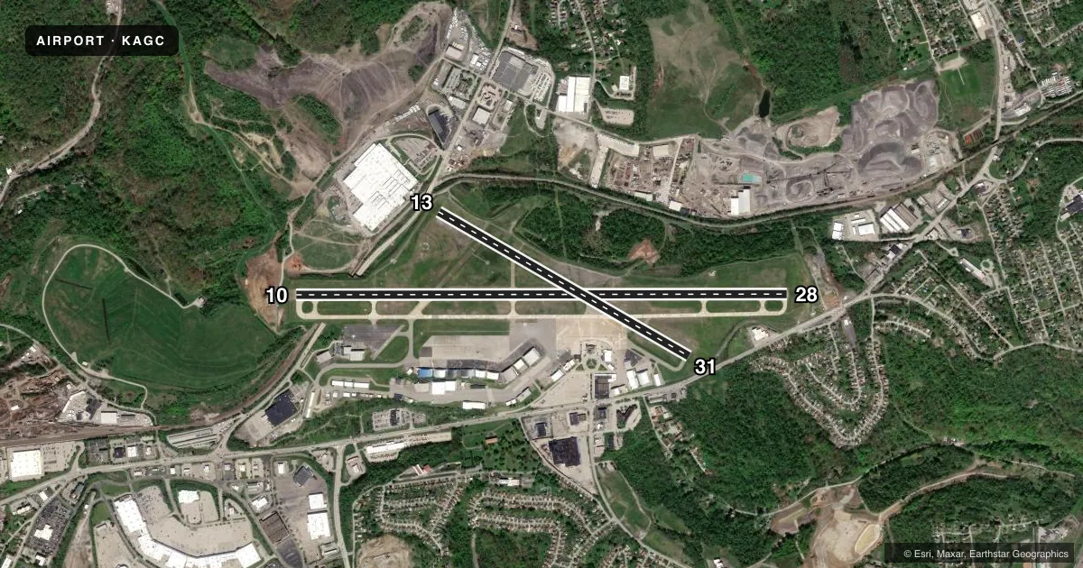
Runways & pattern
Full pagePattern entry · RWY 28
LEFT TRAFFIC| Runway | Heading (°M) | Length | Surface | Traffic |
|---|---|---|---|---|
| 10/28Favored | 81° / 261° | 6,501 ft | CONC | Standard L |
| 13/31 | 111° / 291° | 3,825 ft | CONC | Standard L |
Runway end performance
| End | TORA | TODA | ASDA | LDA | VGSI | Approach lights | Obstruction |
|---|---|---|---|---|---|---|---|
| 10 | — | — | — | — | VASI 4-box left(3°) | — | — |
| 28 | — | — | — | — | — | MALS | 64', trees, 2613' from thr, 433' R of cntrln, slope 37 |
| 31 | — | — | — | — | — | — | 11', trees, 314' from thr, 119' R of cntrln, slope 10 |
Declared distances in feet. TORA = takeoff run available, TODA = takeoff distance, ASDA = accelerate-stop, LDA = landing distance.
Airport sketch
Runways drawn to scale from FAA survey coordinates, rendered over satellite imagery. Not for navigation.
Approaches & charts
ILS · 2
Services on the field
Fuel grades, oxygen, maintenance, ramp storage and lighting — as declared to the FAA by the airport operator.
Fuel & services
- Fuel
- 100LLAA+
- Oxygen (bottled)
- HIGH/LOW
- Oxygen (bulk)
- HIGH/LOW
- Airframe repair
- Major
- Power plant repair
- Major
- Other services
- AFRT,AMB,AVNCS,CARGO,CHTR,INSTR
Ramp & ground
- Transient storage
- Tie-down
- Hangar
- Landing fee
- Yes
- Customs
- Not available
- Lighting schedule
- SEE RMK
- Beacon schedule
- SS-SR
- Beacon
- White / Green (civil land)(WG)
- Wind indicator
- Lighted
- Segmented circle
- No
Fuel & FBOs
Cheapest 100LL and Jet A on the field and nearby. Always confirm with the FBO before taxi.
Airport notes
Surface conditions, obstructions, local procedures, lighting outages and other notes published with each FAA cycle.
General notes
- BIRDS & DEER ON & INVOF ARPT.
- APN MAIN TRML RAMP PRKG 12HR PPR 412-759-7897.
Lighting notes
- ATC-CTL.
Fuel notes
- A+JET A ANTI-ICE AVBL ON REQ.
Runway surface & condition
- H1HELIPAD LCTD ON GA APN E OF TWY C.
Other notes
- IN OPERN PRIOR TO 1959.
- LNDG FEE FOR ACFT 5000 LBS & ABV TO INCL ALL HELS.
VFR map & nearby airports
VFR sectional. Tap any ICAO chip to open that airport.
Key facts · KAGC
Answer card- ICAO
- KAGC
- Name
- ALLEGHENY COUNTY
- Location
- PITTSBURGH, PENNSYLVANIA
- Elevation
- 1,251.5 ft MSL
- Traffic pattern altitude
- 2,251.5 ft MSL (1,000 AGL)
- Control tower
- Towered · 24
- Total runways
- 2
- Longest runway
- 10/28 · 6,501 ft
- Published ILS approaches
- 2
- Published frequencies
- 11
- Magnetic variation
- 9°
- Current flight rules
- MVFR
- Current wind
- 260° at 7 kt
- Favored runway now
- RWY 28
Allegheny County Airport sits in Pittsburgh, Pennsylvania. Field elevation is 1,251.5 ft MSL. The airport has 2 concrete runways. The longest is 6,501 ft on 10/28. The other runway is 13/31 at 3,825 ft. The tower is open 24 hours. Two ILS approaches are published for runway ends 10 and 28.
Pattern altitude is not published in the facts. Use the standard 1,000 ft AGL for light piston traffic unless ATC or the current Chart Supplement says otherwise. The airport is inside Pittsburgh Class B airspace. Expect busy radio work and stay sharp on clearances. The published remarks also call out birds and deer in the area. That matters on taxi, takeoff and landing.
Atlantic Aviation is on the field. It carries 100LL and Jet A. Vantage Aviation, formerly Corporate Air, is also on the field. It carries 100LL, Jet A and Jet A Prist. Jet A with anti-ice is available on request. Main terminal ramp parking is limited to 12 hours with prior permission. A landing fee applies to aircraft 5,000 lb and above. That includes helicopters. The airport has been operating since before 1959. The helipad is on the general aviation apron east of taxiway C.