METAR & TAF KACT
Current METAR
Observed 12:51Z
KACT 271251Z 19009KT 10SM CLR 26/22 A2997 RMK AO2 SLP142 T02560222 $
- Wind
- 190° @ 9 kt
- Visibility
- 10 SM
- Temp / Dew
- 26°C / 22°C
- Altimeter
- 29.97 inHg
- Clouds
- CLR
- Density alt
- 1,898 ft
- Ceiling
- Unlimited
- Rules
- VFR
Airport info & contacts
Manager on record, flight service, ARTCC, attendance schedule and pattern altitude — published by the FAA and refreshed every 28 days.
Location
- From city
- 5 NM NW
- VFR sectional
- SAN ANTONIO
- ARTCC
- ZFW · FORT WORTH
- NOTAM facility
- ACT (NOTAM-D)
Airport manager
- Name
- JAMES C. HARRIS
- Phone
- 254-750-8656
- Address
- 7909 KARL MAY DRIVE, 2ND FLOOR, ADMINISTRATION OFFICE, WACO TX 76708
Flight service · Hours
- FSS FTW
- FORT WORTH1-800-WX-BRIEF
- Attendance
- 0600-2200
Frequencies
Tap any row to copy the frequency to your clipboard.
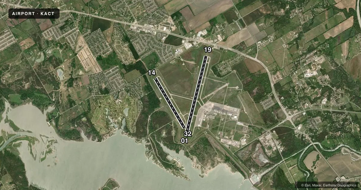
Runways & pattern
Full pagePattern entry · RWY 19
LEFT TRAFFIC| Runway | Heading (°M) | Length | Surface | Traffic |
|---|---|---|---|---|
| 01/19Favored | 7° / 187° | 7,107 ft | ASPH | Standard L |
| 14/32 | 142° / 322° | 5,103 ft | ASPH | Standard L |
Runway end performance
| End | TORA | TODA | ASDA | LDA | VGSI | Approach lights | Obstruction |
|---|---|---|---|---|---|---|---|
| 01 | 7,107' | 7,107' | 7,107' | 7,005' | PAPI 4-box right(3°) | — | 10', road, 650' from thr, 0' R of cntrln, slope 45 |
| 19 | 7,107' | 7,107' | 6,605' | 6,605' | — | MALSR | — |
| 14 | 5,103' | 5,103' | 5,103' | 5,103' | PAPI 4-box left(3°) | — | — |
| 32 | 5,103' | 5,103' | 5,103' | 5,103' | PAPI 4-box left(3°) | — | 10', road, 550' from thr, 0' R of cntrln, slope 35 |
Declared distances in feet. TORA = takeoff run available, TODA = takeoff distance, ASDA = accelerate-stop, LDA = landing distance.
Airport sketch
Runways drawn to scale from FAA survey coordinates, rendered over satellite imagery. Not for navigation.
Approaches & charts
ILS · 1
Services on the field
Fuel grades, oxygen, maintenance, ramp storage and lighting — as declared to the FAA by the airport operator.
Fuel & services
- Fuel
- 100LLAUL94
- Oxygen (bottled)
- Not available
- Oxygen (bulk)
- High pressure
- Airframe repair
- Major
- Power plant repair
- Major
- Other services
- CHTR,INSTR,RNTL,SALES
Ramp & ground
- Transient storage
- Tie-down
- Hangar
- Landing fee
- Yes
- Customs
- Not available
- Lighting schedule
- SEE RMK
- Beacon schedule
- SS-SR
- Beacon
- White / Green (civil land)(WG)
- Wind indicator
- Lighted
- Segmented circle
- Yes
Fuel & FBOs
Cheapest 100LL and Jet A on the field and nearby. Always confirm with the FBO before taxi.
Airport notes
Surface conditions, obstructions, local procedures, lighting outages and other notes published with each FAA cycle.
General notes
- FOR CD CTC WACO APCH AT 121.9 OR CTC FORT WORTH ARTCC AT 817-858-7584.
- PPR RQRD FOR UNSKED ACR OPNS. CALL ARPT OPS AT 254-750-8656 OR SUBMIT ONLINE AT HTTPS://PORTAL.AEROSIMPLE.COM/FORMS/US/2E387A38-D506-11EB-946D-0A58A9FEAC02
Lighting notes
- WHEN ATCT CLSD: MALSR RWY 19; HIRL RWY 01/19 PRESET LOW INTST, TO INCR INTST ACTVT - CTAF. REIL RWY 14; MIRL RWY 14/32; TWY LGTS PRESET LOW INTST WHEN WIND FAVORS, OTRW NOT AVBL.
Runway surface & condition
- 01/19PCR VALUE: 547/F/B/W/T
- 14/32PCR VALUE: 462/F/B/W/T
Other notes
- PPR FOR UNSKED ACR OPNS CALL AMGR 254-750-8657.
- LDG FEE FOR ACRFT OVR 7500 LBS.
VFR map & nearby airports
VFR sectional. Tap any ICAO chip to open that airport.
Key facts · KACT
Answer card- ICAO
- KACT
- Name
- WACO RGNL
- Location
- WACO, TEXAS
- Elevation
- 516.1 ft MSL
- Traffic pattern altitude
- 1,516.1 ft MSL (1,000 AGL)
- Control tower
- Towered · 0600-0000
- Total runways
- 2
- Longest runway
- 01/19 · 7,107 ft
- Published ILS approaches
- 1
- Published frequencies
- 11
- Magnetic variation
- 7°
- Current flight rules
- VFR
- Current wind
- 190° at 9 kt
- Favored runway now
- RWY 19
Waco Rgnl sits in Waco, Texas at 516.1 ft MSL. It has two asphalt runways. The longest is 01/19 at 7,107 ft. The tower is open from 0600 to 0000. There is one ILS approach. It serves runway 19.
Pattern altitude is not published in the facts. Use the standard 1,000 ft AGL for light piston traffic unless the current Chart Supplement says otherwise. Freeman Jet Center - Waco is on the field. It carries 100LL, Jet A Prist and UL94. Call ahead if you need ramp or fuel details before arrival.
A few operational notes matter here. Prior permission is required for unscheduled aircraft operations. Call the airport manager before you go. Clearance delivery is handled through Waco Approach on 121.9 or Fort Worth ARTCC at 817-858-7584. When the tower is closed, runway 19 has MALSR available. Runways 01 and 19 use high intensity lights that start at low intensity. You can increase them on the CTAF. Runway 14 has runway end identifier lights. Runways 14 and 32 have medium intensity lighting. Taxiway lights are preset low when the wind favors. Otherwise they are not available.