METAR & TAF 98G
98G does not publish a METAR.
Showing the nearest reporting station: KCFS (TUSCOLA AREA) · 16.3 NM away. Conditions at 98G may differ.
METAR · KCFS
Observed 23:46Z
KCFS 272346Z AUTO 24004KT CLR 26/19 A2968 RMK AO2
- Wind
- 240° @ 4 kt
- Visibility
- —
- Temp / Dew
- 26°C / 19°C
- Altimeter
- 29.68 inHg
- Clouds
- CLR
- Density alt
- 2,342 ft
- Ceiling
- Unlimited
- Rules
- VFR
Airport info & contacts
Manager on record, flight service, ARTCC, attendance schedule and pattern altitude — published by the FAA and refreshed every 28 days.
Location
- From city
- 0 NM W
- VFR sectional
- DETROIT
- ARTCC
- ZOB · CLEVELAND
- NOTAM facility
- LAN (NOTAM-D)
Airport manager
- Name
- BRENT BOWMAN
- Phone
- 989-553-1519
- Address
- 14 E SHARPSTEEN ST, SEBEWAING MI 48759-1021
Flight service · Hours
- FSS LAN
- LANSING1-800-WX-BRIEF
- Attendance
- IREG
Frequencies
Tap any row to copy the frequency to your clipboard.
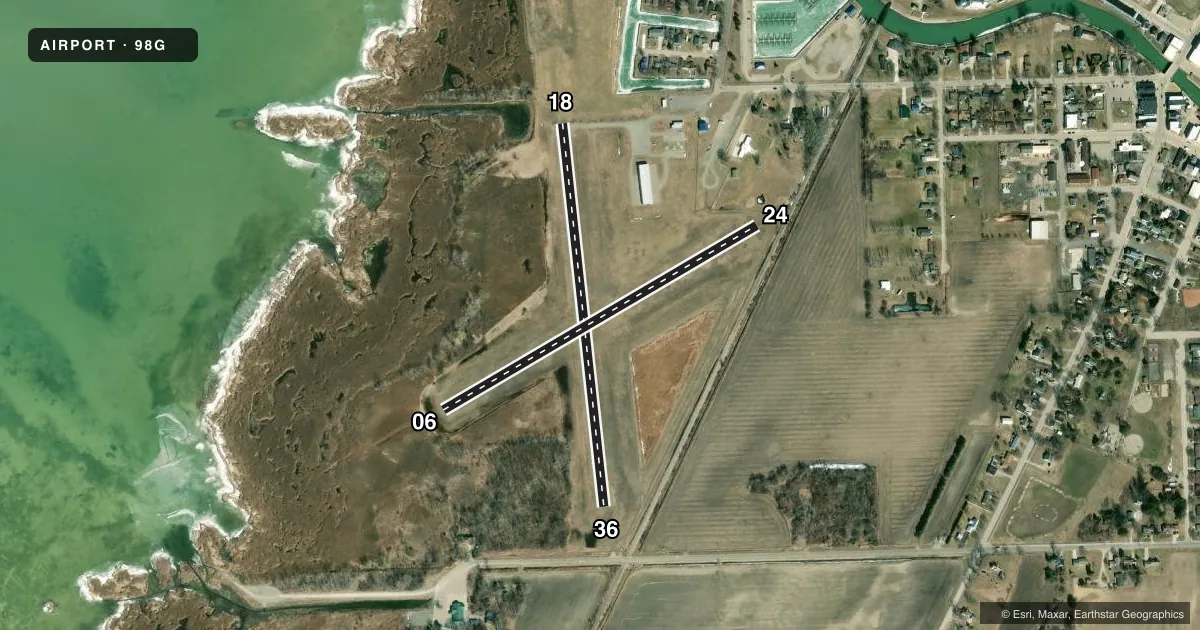
Runways & pattern
Full pagePattern entry · RWY 24
LEFT TRAFFIC| Runway | Heading (°M) | Length | Surface | Traffic |
|---|---|---|---|---|
| 18/36 | 168° / 348° | 2,178 ft | ASPH | Standard L |
| 06/24Favored | 54° / 234° | 2,060 ft | TURF | Standard L |
Runway end performance
| End | TORA | TODA | ASDA | LDA | VGSI | Approach lights | Obstruction |
|---|---|---|---|---|---|---|---|
| 18 | — | — | — | — | — | — | 5', brush, 200' from thr, 125' R of cntrln, slope 1 |
| 36 | — | — | — | — | — | — | 26', rr, 269' from thr, 133' R of cntrln, slope 2 |
| 06 | — | — | — | — | — | — | 6', brush, 0' from thr, 115' R of cntrln, slope 1 |
| 24 | — | — | — | — | — | — | 23', rr, 76' from thr, 134' R of cntrln, slope 1 |
Declared distances in feet. TORA = takeoff run available, TODA = takeoff distance, ASDA = accelerate-stop, LDA = landing distance.
Airport sketch
Runways drawn to scale from FAA survey coordinates, rendered over satellite imagery. Not for navigation.
Approaches & charts
Services on the field
Fuel grades, oxygen, maintenance, ramp storage and lighting — as declared to the FAA by the airport operator.
Fuel & services
- Fuel
- 100LL
- Oxygen (bottled)
- Not available
- Oxygen (bulk)
- Not available
- Airframe repair
- Major
- Power plant repair
- Major
Ramp & ground
- Transient storage
- Tie-down
- Landing fee
- No fee published
- Customs
- Not available
- Lighting schedule
- SEE RMK
- Wind indicator
- Lighted
- Segmented circle
- Yes
Fuel & FBOs
Cheapest 100LL and Jet A on the field and nearby. Always confirm with the FBO before taxi.
Airport notes
Surface conditions, obstructions, local procedures, lighting outages and other notes published with each FAA cycle.
General notes
- DEER & LRG BIRDS ON & INVOF ARPT.
- FOR CD CTC GREAT LAKES APCH AT 269-459-3345, WHEN APCH CLSD CTC CLEVELAND ARTCC AT 440-774-0224/0490.
Lighting notes
- ACTVT LIRL RWY 18/36 DUSK-DAWN - CTAF.
Fuel notes
- 100LLFOR FUEL SVC CTC AMGR.
Approach & departure obstructions
- 063 FT CONES.
- 243 FT CONES.
- 24APCH RATIO 20:1 TO DTHR.
- 36APCH RATIO 20:1 TO DTHR.
Other notes
- AVBL BY PRIOR ARNGMT CALL AMGR.
- AVBL BY PRIOR ARNGMT CALL AMGR.
VFR map & nearby airports
VFR sectional. Tap any ICAO chip to open that airport.
Key facts · 98G
Answer card- ICAO
- 98G
- Name
- SEBEWAING TOWNSHIP
- Location
- SEBEWAING, MICHIGAN
- Elevation
- 584 ft MSL
- Traffic pattern altitude
- 1,584 ft MSL (1,000 AGL)
- Control tower
- Non-towered (use CTAF)
- Total runways
- 2
- Longest runway
- 18/36 · 2,178 ft
- Published ILS approaches
- 0
- Published frequencies
- 2
- Magnetic variation
- 6°
- Current flight rules
- VFR
- Current wind
- 240° at 4 kt
- Favored runway now
- RWY 24
Sebewaing Township Airport sits in Sebewaing, Michigan. The field elevation is 584 ft MSL. It has two runways. The longest is runway 18/36 at 2,178 ft. Runway 06/24 is turf and measures 2,060 ft. There is no control tower. CTAF and UNICOM are both 122.8.
No ILS approaches are published here. Pattern altitude is not published, so use the standard 1,000 ft AGL for light piston operations unless the current Chart Supplement says otherwise. The on-field FBO is Sebewaing Township Airport. It carries 100LL. Call the airport manager at (989) 883-2120 for fuel service and prior-arranged maintenance. Published remarks also note deer and large birds in the area. That matters on arrival and departure.
Runway 18/36 has low intensity lights. They are activated from dusk to dawn by CTAF. The published remarks also call out a 20:1 approach clearance slope to the displaced thresholds on runways 24 and 36. There are 3 foot cones on runway 24 and runway 06. If you are planning a first visit, brief the short runway lengths, the turf surface on 06/24 and the wildlife risk. For current clearance delivery details, use the published Great Lakes Approach or Cleveland ARTCC numbers in the Chart Supplement.