METAR & TAF 75C
75C does not publish a METAR.
Showing the nearest reporting station: KGIC (IDAHO COUNTY) · 28.0 NM away. Conditions at 75C may differ.
METAR · KGIC
Observed 17:55Z
KGIC 261755Z AUTO 05007KT 10SM CLR 23/08 A3009 RMK AO1
- Wind
- 050° @ 7 kt
- Visibility
- 10 SM
- Temp / Dew
- 23°C / 8°C
- Altimeter
- 30.09 inHg
- Clouds
- CLR
- Density alt
- 6,229 ft
- Ceiling
- Unlimited
- Rules
- VFR
Airport info & contacts
Manager on record, flight service, ARTCC, attendance schedule and pattern altitude — published by the FAA and refreshed every 28 days.
Location
- From city
- 1 NM NE
- VFR sectional
- GREAT FALLS
- ARTCC
- ZSE · SEATTLE
- NOTAM facility
- BOI (NOTAM-D)
Airport manager
- Name
- JEREMY BEESON-NEZPERCE NF AV. OFCR
- Phone
- 208-451-6710
- Address
- 111 AIRPORT WAY, GRANGEVILLE ID 83530
Flight service · Hours
- FSS BOI
- BOISE1-800-WX-BRIEF
- Attendance
- Unattended
Frequencies
Tap any row to copy the frequency to your clipboard.
Runways & pattern
Full pagePattern entry · RWY 01
LEFT TRAFFICRunway end performance
| End | TORA | TODA | ASDA | LDA | VGSI | Approach lights | Obstruction |
|---|---|---|---|---|---|---|---|
| 01 | — | — | — | — | — | — | 50', trees, 25' from thr, 30' R of cntrln, slope 0 |
| 19 | — | — | — | — | — | — | 50', trees, 30' from thr, 75' R of cntrln, slope 0 |
Declared distances in feet. TORA = takeoff run available, TODA = takeoff distance, ASDA = accelerate-stop, LDA = landing distance.
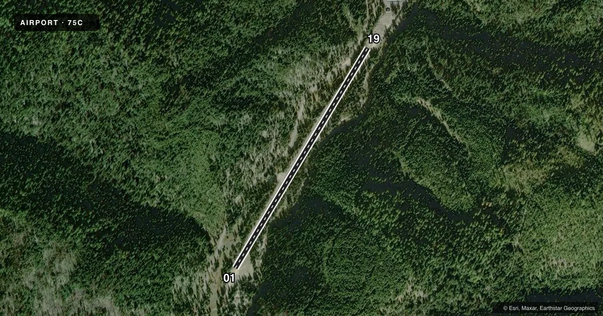
Airport sketch
Runways drawn to scale from FAA survey coordinates, rendered over satellite imagery. Not for navigation.
Approaches & charts
Services on the field
Fuel grades, oxygen, maintenance, ramp storage and lighting — as declared to the FAA by the airport operator.
Fuel & services
- Fuel
- Not available
Ramp & ground
- Transient storage
- Not published
- Wind indicator
- Yes
- Segmented circle
- Yes
Fuel & FBOs
Cheapest 100LL and Jet A on the field and nearby. Always confirm with the FBO before taxi.
Airport notes
Surface conditions, obstructions, local procedures, lighting outages and other notes published with each FAA cycle.
General notes
- BIG GAME ANIMALS ON AND INVOF ARPT.
- VEHICLES HAVE ACCESS TO RUNWAY
- RECOMMENDED USE EARLY MORNING AND LATE EVENING IN SUMMER.
- +75 FT TREES ON APCH TO BOTH RWY ENDS.
- FOR CD CTC SEATTLE ARTCC AT 253-351-3694.
Runway surface & condition
- 01/19LAND RY 19; DEPART RY 01 WHEN WIND CONDITIONS PERMIT.
Approach & departure obstructions
- 01CONTROLLING OBSTRUCTION = 50 FT TREES IN CLOSE PROXIMITY TO RWY 19 END, 75 FT RIGHT OF RWY CNTRLN.
Other notes
- PRVDD VFR ONLY.
- NO TIE-DOWN CHAINS; ONLY 60 FT OF ABV GND STEELE CABLE AVBL AS TIE-DOWN/ANCHOR.
VFR map & nearby airports
VFR sectional. Tap any ICAO chip to open that airport.
Key facts · 75C
Answer card- ICAO
- 75C
- Name
- OROGRANDE
- Location
- OROGRANDE, IDAHO
- Elevation
- 4,419 ft MSL
- Traffic pattern altitude
- 5,419 ft MSL (1,000 AGL)
- Control tower
- Non-towered (use CTAF)
- Total runways
- 1
- Longest runway
- 01/19 · 2,800 ft
- Published ILS approaches
- 0
- Published frequencies
- 1
- Magnetic variation
- 17°
- Current flight rules
- VFR
- Current wind
- 050° at 7 kt
- Favored runway now
- RWY 01
OROGRANDE (75C) sits in OROGRANDE, Idaho at 4,419 ft MSL. It has one runway. Runway 01/19 is 2,800 ft long with a turf-dirt surface. This is a non-towered field, so CTAF is 122.9. No ILS approaches are published. The published pattern altitude is not listed, so use standard 1,000 ft AGL for light piston operations unless the current Chart Supplement says otherwise.
The field is VFR only. Trees are a real factor here. The published remarks call out 50-foot trees close to the runway 19 end, 75 feet right of centerline. Trees over 75 feet tall are also noted on approach to both runway ends. The remarks also say to land runway 19 and depart runway 01 when wind conditions permit. That is worth planning around before you go.
There are no on-field FBOs listed. Vehicles have access to the runway. No tie-down chains are available. Only 60 feet of above-ground steel cable is available for tie-down or anchor use. Big game animals are also reported on and near the airport. For clearance delivery, contact Seattle ARTCC at 253-351-3694. Check the current Chart Supplement before flight for any additional operational notes.