METAR & TAF 2U5
2U5 does not publish a METAR.
Showing the nearest reporting station: KHRF (RAVALLI COUNTY) · 33.9 NM away. Conditions at 2U5 may differ.
METAR · KHRF
Observed 05:15Z
KHRF 270515Z AUTO 36013KT 10SM CLR 21/08 A3002 RMK AO2
- Wind
- 360° @ 13 kt
- Visibility
- 10 SM
- Temp / Dew
- 21°C / 8°C
- Altimeter
- 30.02 inHg
- Clouds
- CLR
- Density alt
- 3,862 ft
- Ceiling
- Unlimited
- Rules
- VFR
Airport info & contacts
Manager on record, flight service, ARTCC, attendance schedule and pattern altitude — published by the FAA and refreshed every 28 days.
Location
- From city
- 0 NM S
- VFR sectional
- GREAT FALLS
- ARTCC
- ZLC · SALT LAKE CITY
- NOTAM facility
- BOI (NOTAM-D)
Airport manager
- Name
- NEZPERCE FOREST AIR OFFICER
- Phone
- 208-983-9571
- Address
- 104 AIRPORT RD, GRANGEVILLE ID 83530
Flight service · Hours
- FSS BOI
- BOISE1-800-WX-BRIEF
- Attendance
- Unattended
Frequencies
Tap any row to copy the frequency to your clipboard.
Runways & pattern
Full pagePattern entry · RWY 36
LEFT TRAFFICRunway end performance
| End | TORA | TODA | ASDA | LDA | VGSI | Approach lights | Obstruction |
|---|---|---|---|---|---|---|---|
| 18 | — | — | — | — | — | — | 500', hill, 1750' from thr, 0' R of cntrln, slope 3 |
| 36 | — | — | — | — | — | — | 85', trees, 200' from thr, 0' R of cntrln, slope 2 |
Declared distances in feet. TORA = takeoff run available, TODA = takeoff distance, ASDA = accelerate-stop, LDA = landing distance.
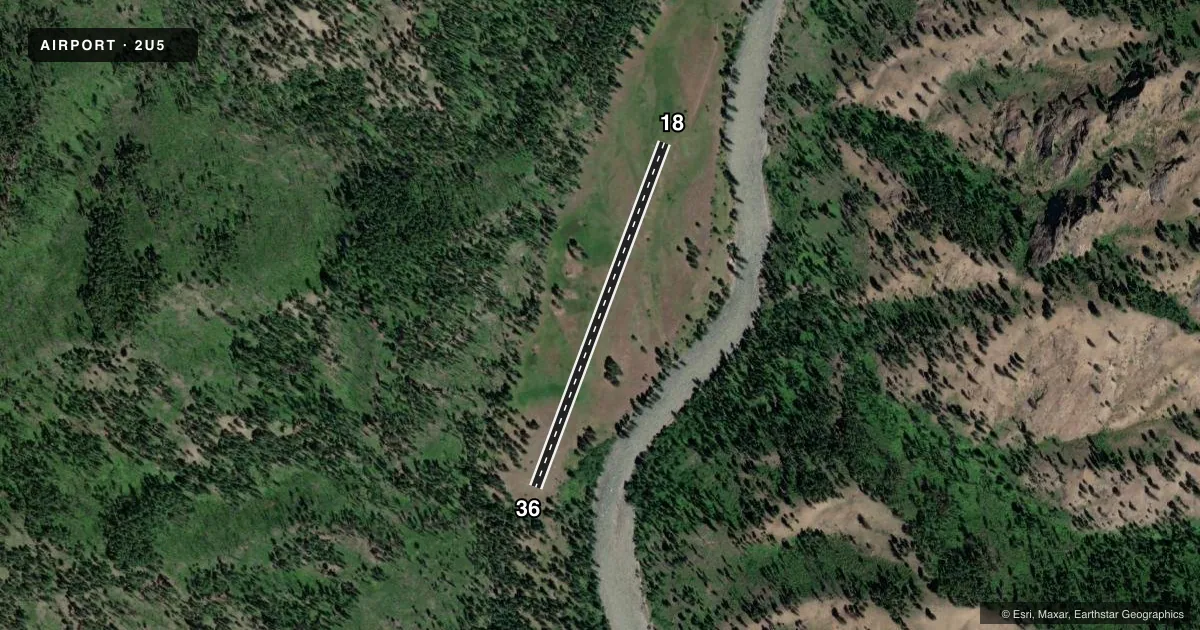
Airport sketch
Runways drawn to scale from FAA survey coordinates, rendered over satellite imagery. Not for navigation.
Approaches & charts
Services on the field
Fuel grades, oxygen, maintenance, ramp storage and lighting — as declared to the FAA by the airport operator.
Fuel & services
- Fuel
- Not available
- Oxygen (bottled)
- Not available
- Oxygen (bulk)
- Not available
- Airframe repair
- Not available
- Power plant repair
- Not available
Ramp & ground
- Transient storage
- Not published
- Landing fee
- No fee published
- Wind indicator
- Yes
- Segmented circle
- No
Fuel & FBOs
Cheapest 100LL and Jet A on the field and nearby. Always confirm with the FBO before taxi.
Airport notes
Surface conditions, obstructions, local procedures, lighting outages and other notes published with each FAA cycle.
General notes
- LCTD IN NARROW WINDING RIVER CANYON.
- BIG GAME ANIMALS ON & INVOF ARPT.
- BLIND APCH TO RWY 18; BEFORE LANDING/TAKE-OFF CALL ON FREQ 122.9; MONTR SAME.
- INEXPERIENCED PILOTS SHOULD USE FOR EMERGENCIES ONLY. RECOMMEND EARLY MORNING OR LATE EVENING OPERATIONS DURING SUMMER.
- RY MAY BE SOFT IN SPRING AND LATE FALL.
- FOR CD CTC SALT LAKE ARTCC AT 801-320-2568.
Runway surface & condition
- 18/36RECOMMEND LAND RY 18; TKOF RY 36.
Other notes
- EXISTED PRIOR TO 5/15/59.
- 18/36FIRST 300 FT OF RY 18 ROUGH WITH TALL GRASS.
VFR map & nearby airports
VFR sectional. Tap any ICAO chip to open that airport.
Key facts · 2U5
Answer card- ICAO
- 2U5
- Name
- SHEARER /USFS/
- Location
- SHEARER, IDAHO
- Elevation
- 2,634 ft MSL
- Traffic pattern altitude
- 3,634 ft MSL (1,000 AGL)
- Control tower
- Non-towered (use CTAF)
- Total runways
- 1
- Longest runway
- 18/36 · 2,000 ft
- Published ILS approaches
- 0
- Published frequencies
- 1
- Magnetic variation
- 18°
- Current flight rules
- VFR
- Current wind
- 360° at 13 kt
- Favored runway now
- RWY 36
SHEARER /USFS/ sits in Shearer, Idaho at 2,634 ft MSL. It has one runway, 18/36, which is 2,000 ft long and turf. There is no control tower. CTAF is 122.9. No ILS approaches are published here. The pattern altitude is not published, so use the standard 1,000 ft AGL for light piston operations unless the current Chart Supplement says otherwise.
This is a canyon field. The published remarks say it is in a narrow winding river canyon. Big game animals are also on and near the airport. The runway may be soft in spring and late fall. The first 300 ft of runway 18 is rough with tall grass. The remarks also recommend landing on runway 18 and taking off from runway 36. There is a blind approach to runway 18, so call on 122.9 before landing or takeoff and monitor the same frequency.
There are no on-field FBOs listed. Check with the airport operator or the FBO directly by phone if you need current services. For clearance delivery, contact Salt Lake ARTCC at 801-320-2568. Inexperienced pilots should treat this as an emergency-use field only. Summer early morning or late evening operations are recommended.