METAR & TAF KHRF
Current METAR
Observed 11:15Z
KHRF 271115Z AUTO 15004KT 10SM SCT080 11/08 A3010 RMK AO2
- Wind
- 150° @ 4 kt
- Visibility
- 10 SM
- Temp / Dew
- 11°C / 8°C
- Altimeter
- 30.10 inHg
- Clouds
- SCT
- Density alt
- 3,805 ft
- Ceiling
- Unlimited
- Rules
- VFR
Airport info & contacts
Manager on record, flight service, ARTCC, attendance schedule and pattern altitude — published by the FAA and refreshed every 28 days.
Location
- From city
- 1 NM E
- VFR sectional
- GREAT FALLS
- Pattern altitude
- 800 ft AGL · 4,436 ft MSL
- ARTCC
- ZLC · SALT LAKE CITY
- NOTAM facility
- GTF (NOTAM-D)
Airport manager
- Name
- TIM SMEAD
- Phone
- 406-375-6639
- Address
- 215 S. 4TH STREET, SUITE A, HAMILTON MT 59840
Flight service · Hours
- FSS GTF
- GREAT FALLS1-800-WX-BRIEF
- Attendance
- 0800-1700
Frequencies
Tap any row to copy the frequency to your clipboard.
Runways & pattern
Full pagePattern entry · RWY 17
LEFT TRAFFICRunway end performance
| End | TORA | TODA | ASDA | LDA | VGSI | Approach lights | Obstruction |
|---|---|---|---|---|---|---|---|
| 17 | — | — | — | — | PAPI 2-box left(3°) | — | — |
| 35 | — | — | — | — | PAPI 2-box left(3°) | — | — |
Declared distances in feet. TORA = takeoff run available, TODA = takeoff distance, ASDA = accelerate-stop, LDA = landing distance.
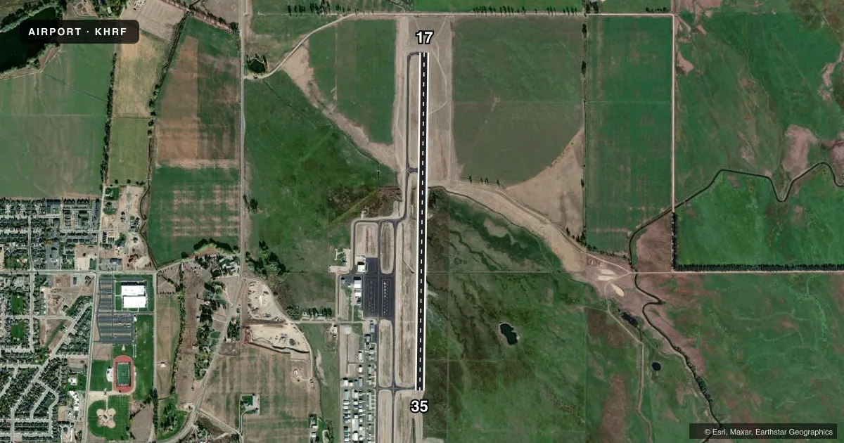
Airport sketch
Runways drawn to scale from FAA survey coordinates, rendered over satellite imagery. Not for navigation.
Approaches & charts
Services on the field
Fuel grades, oxygen, maintenance, ramp storage and lighting — as declared to the FAA by the airport operator.
Fuel & services
- Fuel
- 100LLAA+
- Airframe repair
- Major
- Power plant repair
- Major
- Other services
- AMB,CHTR,INSTR,PAJA,RNTL,SALES
Ramp & ground
- Transient storage
- Tie-down
- Hangar
- Landing fee
- Yes
- Customs
- Not available
- Lighting schedule
- SEE RMK
- Beacon schedule
- SS-SR
- Beacon
- White / Green (civil land)(WG)
- Wind indicator
- Lighted
- Segmented circle
- Yes
Fuel & FBOs
Cheapest 100LL and Jet A on the field and nearby. Always confirm with the FBO before taxi.
Airport notes
Surface conditions, obstructions, local procedures, lighting outages and other notes published with each FAA cycle.
General notes
- FOR CD CTC SALT LAKE ARTCC AT 801-320-2568.
- RWY 17/35 IS LTD BY THE ARPT OPR TO ACFT MAX GWT TKOF 40000 LBS SW AND 53000 LBS DW WO PPR.
Lighting notes
- ACTVT PAPI RWY 17, 35; MIRL RWY 17/35 - CTAF. FOR MIRL RWY 17/35 DRG DALGT HRS CTC AP MGR 406-375-9149.
- ULTRALIGHT ACTIVITY ON & INVOF ARPT.
Other notes
- LDG FEE FOR ACFT OVR 17000 LBS.
VFR map & nearby airports
VFR sectional. Tap any ICAO chip to open that airport.
Key facts · KHRF
Answer card- ICAO
- KHRF
- Name
- RAVALLI COUNTY
- Location
- HAMILTON, MONTANA
- Elevation
- 3,635.6 ft MSL
- Traffic pattern altitude
- 4,435.6 ft MSL (800 AGL)
- Control tower
- Non-towered (use CTAF)
- Total runways
- 1
- Longest runway
- 17/35 · 5,200 ft
- Published ILS approaches
- 0
- Published frequencies
- 2
- Magnetic variation
- 13°
- Current flight rules
- VFR
- Current wind
- 150° at 4 kt
- Favored runway now
- RWY 17
Ravalli County Airport sits in Hamilton, Montana. The field elevation is 3,635.6 ft MSL. It has one runway. Runway 17/35 is 5,200 ft of asphalt, which is the longest runway on the field. There is no control tower. CTAF and UNICOM are both 122.8.
Pattern altitude is 800 ft AGL, which puts the traffic pattern at 4,435.6 ft MSL. No ILS approaches are published here, so plan with the current charted procedures and weather minimums in mind. Ascension FBO is on the field. It carries AVGAS 100LL, JET A and JET A Prist. Ultralight activity occurs on and near the airport, so keep a sharp scan in the pattern and on departure.
The published remarks also note runway use limits tied to aircraft maximum gross weight on 17/35. Aircraft over 17,000 pounds pay a landing fee. The runway lights and PAPI are pilot-controlled on CTAF. For medium intensity runway lights during daylight hours, contact the airport manager. This is a mountain valley airport with a high field elevation, so performance planning matters. Check density altitude, climb out options and current weather before you go. For clearance delivery, contact Salt Lake ARTCC.