METAR & TAF 32S
32S does not publish a METAR.
Showing the nearest reporting station: KHRF (RAVALLI COUNTY) · 16.4 NM away. Conditions at 32S may differ.
METAR · KHRF
Observed 12:35Z
KHRF 271235Z AUTO 00000KT 9SM CLR 11/08 A3011 RMK AO2
- Wind
- 000° @ 0 kt
- Visibility
- 9 SM
- Temp / Dew
- 11°C / 8°C
- Altimeter
- 30.11 inHg
- Clouds
- CLR
- Density alt
- 3,765 ft
- Ceiling
- Unlimited
- Rules
- VFR
Airport info & contacts
Manager on record, flight service, ARTCC, attendance schedule and pattern altitude — published by the FAA and refreshed every 28 days.
Location
- From city
- 2 NM NE
- VFR sectional
- GREAT FALLS
- Pattern altitude
- 800 ft AGL · 4,414 ft MSL
- ARTCC
- ZLC · SALT LAKE CITY
- NOTAM facility
- GTF (NOTAM-D)
Airport manager
- Name
- BRIAN GERMANE
- Phone
- 406-880-3361
- Address
- PO BOX 30, STEVENSVILLE MT 59870
Flight service · Hours
- FSS GTF
- GREAT FALLS1-800-WX-BRIEF
- Attendance
- Unattended
Frequencies
Tap any row to copy the frequency to your clipboard.
Runways & pattern
Full pagePattern entry · RWY 12
LEFT TRAFFICRunway end performance
| End | TORA | TODA | ASDA | LDA | VGSI | Approach lights | Obstruction |
|---|---|---|---|---|---|---|---|
| 12 | — | — | — | — | PAPI 2-box left(3°) | — | — |
| 30 | — | — | — | — | — | — | 90', tree, 1700' from thr, 0' R of cntrln, slope 16 |
Declared distances in feet. TORA = takeoff run available, TODA = takeoff distance, ASDA = accelerate-stop, LDA = landing distance.
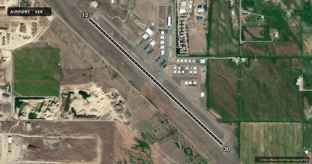
Airport sketch
Runways drawn to scale from FAA survey coordinates, rendered over satellite imagery. Not for navigation.
Approaches & charts
Services on the field
Fuel grades, oxygen, maintenance, ramp storage and lighting — as declared to the FAA by the airport operator.
Fuel & services
- Fuel
- 100LL
- Oxygen (bottled)
- Low pressure
- Airframe repair
- Major
- Power plant repair
- Major
- Other services
- AMB,CHTR,INSTR,RNTL
Ramp & ground
- Transient storage
- Tie-down
- Landing fee
- No fee published
- Customs
- Not available
- Lighting schedule
- SEE RMK
- Beacon schedule
- SS-SR
- Beacon
- White / Green (civil land)(WG)
- Wind indicator
- Lighted
- Segmented circle
- Yes
Fuel & FBOs
Cheapest 100LL and Jet A on the field and nearby. Always confirm with the FBO before taxi.
Airport notes
Surface conditions, obstructions, local procedures, lighting outages and other notes published with each FAA cycle.
General notes
- SN REMOVAL IREG; COND - AMGR.
- FOR CD CTC SPOKANE APCH AT 509-742-2522, WHEN APCH CLSD CTC SALT LAKE ARTCC AT 801-320-2568
Lighting notes
- ACTVT PAPI RWY 12: MIRL RWY 12/30 - CTAF.
Runway surface & condition
- 12/30LND RWY 12; TKOFF RWY 30.
Other notes
- EXISTED PRIOR TO 1959.
- CALM WIND.
VFR map & nearby airports
VFR sectional. Tap any ICAO chip to open that airport.
Key facts · 32S
Answer card- ICAO
- 32S
- Name
- STEVENSVILLE
- Location
- STEVENSVILLE, MONTANA
- Elevation
- 3,613.5 ft MSL
- Traffic pattern altitude
- 4,413.5 ft MSL (800 AGL)
- Control tower
- Non-towered (use CTAF)
- Total runways
- 1
- Longest runway
- 12/30 · 3,809 ft
- Published ILS approaches
- 0
- Published frequencies
- 4
- Magnetic variation
- 16°
- Current flight rules
- VFR
- Current wind
- 000° at 0 kt
- Favored runway now
- –
Stevensville Airport sits in Stevensville, Montana. The field elevation is 3,613.5 ft MSL. It has one runway, 12/30, which is 3,809 ft long and asphalt. There is no control tower. Pattern altitude is 800 ft AGL, which puts the traffic pattern at 4,413.5 ft MSL.
No ILS approaches are published here. CTAF and UNICOM are both 122.8. Spokane Approach handles 124.9 and 298.95. The on-field FBO is Stevensville Airport. It carries AVGAS 100LL. Call (406) 777-5271 for current service details.
A few remarks matter for planning. Snow removal is irregular, so runway condition can change with the airport manager’s availability. The published lighting note says PAPI is active on runway 12. Medium intensity runway lights are on both runway ends. The remarks also say to land on runway 12 and take off from runway 30. This is an unattended field, so use CTAF for position reports and get your clearance details from Spokane Approach or Salt Lake ARTCC if approach is closed. The elevation is high enough that density altitude can matter on warm days. Check performance carefully before departure.