METAR & TAF 4U7
4U7 does not publish a METAR.
Showing the nearest reporting station: KHRF (RAVALLI COUNTY) · 24.0 NM away. Conditions at 4U7 may differ.
METAR · KHRF
Observed 04:15Z
KHRF 240415Z AUTO 01006KT 10SM CLR 20/06 A3011 RMK AO2
- Wind
- 010° @ 6 kt
- Visibility
- 10 SM
- Temp / Dew
- 20°C / 6°C
- Altimeter
- 30.11 inHg
- Clouds
- CLR
- Density alt
- 5,633 ft
- Ceiling
- Unlimited
- Rules
- VFR
Airport info & contacts
Manager on record, flight service, ARTCC, attendance schedule and pattern altitude — published by the FAA and refreshed every 28 days.
Location
- From city
- 5 NM SW
- VFR sectional
- GREAT FALLS
- ARTCC
- ZLC · SALT LAKE CITY
- NOTAM facility
- GTF (NOTAM-D)
Airport manager
- Name
- TEX IRWIN
- Phone
- (831) 884-3602
- Address
- 5855 WEST FORK ROAD, DARBY MT 59829
Flight service · Hours
- FSS GTF
- GREAT FALLS1-800-WX-BRIEF
- Attendance
- UNATTNDD
Frequencies
Tap any row to copy the frequency to your clipboard.
Runways & pattern
Full pagePattern entry · RWY 02
LEFT TRAFFICRunway end performance
| End | TORA | TODA | ASDA | LDA | VGSI | Approach lights | Obstruction |
|---|---|---|---|---|---|---|---|
| 02 | — | — | — | — | — | — | 10', road, 0' from thr, 0' R of cntrln, slope 0 |
| 20 | — | — | — | — | — | — | 10', road, 5' from thr, 0' R of cntrln, slope 0 |
Declared distances in feet. TORA = takeoff run available, TODA = takeoff distance, ASDA = accelerate-stop, LDA = landing distance.
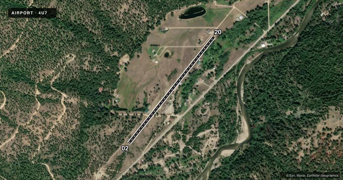
Airport sketch
Runways drawn to scale from FAA survey coordinates, rendered over satellite imagery. Not for navigation.
Approaches & charts
Services on the field
Fuel grades, oxygen, maintenance, ramp storage and lighting — as declared to the FAA by the airport operator.
Fuel & services
- Fuel
- Not available
- Oxygen (bottled)
- Not available
- Oxygen (bulk)
- Not available
- Airframe repair
- Not available
- Power plant repair
- Not available
Ramp & ground
- Transient storage
- Tie-down
- Landing fee
- No fee published
- Customs
- Not available
- Wind indicator
- Yes
- Segmented circle
- No
Fuel & FBOs
Cheapest 100LL and Jet A on the field and nearby. Always confirm with the FBO before taxi.
Airport notes
Surface conditions, obstructions, local procedures, lighting outages and other notes published with each FAA cycle.
General notes
- TREES & STRUCTURES IN TRANSITIONAL SFC FULL LENGTH BOTH SIDES OF RY.
- RWY 02 +70 FT TREES 600 FT FM RWY END & MTN 2700 FT FM THLD; RWY 20 +135 FT TREE 80 FT RIGHT & 120 FT FM RWY END; +115 FT TREES BEGINNING 91 FT RIGHT PENTG APCH SFC.
- LIVESTOCK; BIRDS; & WILDLIFE INVOF APRT.
- STEEP TERRAIN SURROUNDING AIRPORT.
- FOR CD CTC SALT LAKE ARTCC AT 801-320-2568.
- NO SN PLOWING IN WINTER.
Approach & departure obstructions
- 02CTLG OBSTN EXCEEDS A 45 DEG SLP.
Other notes
- 02/20OCNL GRVL DOWN CNTR OF RWY - SML DIP 600 FT FM RWY 20 END.
VFR map & nearby airports
VFR sectional. Tap any ICAO chip to open that airport.
Key facts · 4U7
Answer card- ICAO
- 4U7
- Name
- WEST FORK LODGE
- Location
- CONNER, MONTANA
- Elevation
- 4,249 ft MSL
- Traffic pattern altitude
- 5,249 ft MSL (1,000 AGL)
- Control tower
- Non-towered (use CTAF)
- Total runways
- 1
- Longest runway
- 02/20 · 2,600 ft
- Published ILS approaches
- 0
- Published frequencies
- 1
- Magnetic variation
- 17°
- Current flight rules
- VFR
- Current wind
- 010° at 6 kt
- Favored runway now
- RWY 02
West Fork Lodge Airport (4U7) sits near Conner, Montana. The field elevation is 4,249 ft MSL. It has one runway. Runway 02/20 is 2,600 ft long and surfaced turf-gravel. The airport is non-towered. CTAF is 122.9.
No ILS approaches are published here. Pattern altitude is not published, so use standard traffic pattern planning for light piston aircraft unless the current FAA Chart Supplement says otherwise. The field sits in steep terrain. That matters here. Runway 02 has trees close to the departure end and a mountain farther out. Runway 20 has tall trees near the approach path. Trees and structures also sit in the transitional surface along both sides of the runway. Wildlife is also reported in the area.
Published remarks also note no snow plowing in winter. Runway 02 has a cataloged obstruction that exceeds a 45 degree slope. The runway surface can have occasional gravel down the center. There is also a small dip about 600 feet from the Runway 20 end. No on-field FBOs are listed. Contact the airport operator directly or call the field on CTAF for current local support before you go.