METAR & TAF 1U1
1U1 does not publish a METAR.
Showing the nearest reporting station: KHRF (RAVALLI COUNTY) · 34.1 NM away. Conditions at 1U1 may differ.
METAR · KHRF
Observed 05:55Z
KHRF 270555Z AUTO 36012KT 10SM CLR 20/09 A3004 RMK AO2
- Wind
- 360° @ 12 kt
- Visibility
- 10 SM
- Temp / Dew
- 20°C / 9°C
- Altimeter
- 30.04 inHg
- Clouds
- CLR
- Density alt
- 3,494 ft
- Ceiling
- Unlimited
- Rules
- VFR
Airport info & contacts
Manager on record, flight service, ARTCC, attendance schedule and pattern altitude — published by the FAA and refreshed every 28 days.
Location
- From city
- 0 NM SW
- VFR sectional
- GREAT FALLS
- ARTCC
- ZLC · SALT LAKE CITY
- NOTAM facility
- BOI (NOTAM-D)
Airport manager
- Name
- NEZPERCE FOREST AIR OFFICER
- Phone
- 208-983-9571
- Address
- 104 AIRPORT RD, GRANGEVILLE ID 83530
Flight service · Hours
- FSS BOI
- BOISE1-800-WX-BRIEF
- Attendance
- Unattended
Frequencies
Tap any row to copy the frequency to your clipboard.
Runways & pattern
Full pagePattern entry · RWY 01
LEFT TRAFFICRunway end performance
| End | TORA | TODA | ASDA | LDA | VGSI | Approach lights | Obstruction |
|---|---|---|---|---|---|---|---|
| 01 | — | — | — | — | — | — | 90', trees, 0' from thr, 100' R of cntrln, slope 0 |
| 19 | — | — | — | — | — | — | 100', trees, 150' from thr, 250' R of cntrln, slope 1 |
Declared distances in feet. TORA = takeoff run available, TODA = takeoff distance, ASDA = accelerate-stop, LDA = landing distance.
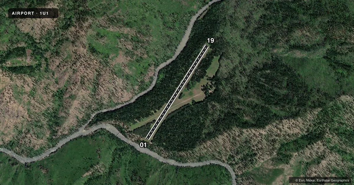
Airport sketch
Runways drawn to scale from FAA survey coordinates, rendered over satellite imagery. Not for navigation.
Approaches & charts
Services on the field
Fuel grades, oxygen, maintenance, ramp storage and lighting — as declared to the FAA by the airport operator.
Fuel & services
- Fuel
- Not available
- Oxygen (bottled)
- Not available
- Oxygen (bulk)
- Not available
- Airframe repair
- Not available
- Power plant repair
- Not available
Ramp & ground
- Transient storage
- Not published
- Landing fee
- No fee published
- Customs
- Not available
- Wind indicator
- Yes
- Segmented circle
- No
Fuel & FBOs
Cheapest 100LL and Jet A on the field and nearby. Always confirm with the FBO before taxi.
Airport notes
Surface conditions, obstructions, local procedures, lighting outages and other notes published with each FAA cycle.
General notes
- NO WINTER MAINTENANCE.
- RYS 01/19 & 04/22 MAY NOT BE MOWED TO FULL WIDTH.
- RY 01/19 MUDDY SPRING & WINTER. USE RY 04/22 EARLY SPRING & LATE FALL/WINTER WHEN PSBL DUE TO BETTER DRAINAGE & FIRMER SFC. RYS SUBJECT TO TEMP CLOSURES.
- BIG GAME ANIMALS ON & INVOF OF ARPT.
- CALL 208-983-9677 FOR RY CONDITIONS.
- FOR CD CTC SALT LAKE ARTCC AT 801-320-2568.
- RWY 19: 100 FT TREES & RISING TRRN AT 150 FT ON EXTDD CNTRLN, 250 FT LEFT.
Runway surface & condition
- 01/19RCMD ARR RWY 19; DEP RWY 01 WHEN WIND CONDS PERMIT.
- 04/22ARR RWY 04; DEP RWY 22; CTN: GO-AROUND NOT RCMDD.
Approach & departure obstructions
- 0190 FT TREES 110 FT LEFT & RIGHT OF THR.
- 0490 FT TREES 100 FT RIGHT OF RWY THR.
- 19100 FT TREES & RISING TRRN AT 150 FT ON EXTDD CNTRLN, 250 FT LEFT.
- 22130 FT TREES 175 FT ON EXTDD CNTRLN.
Other notes
- ESTABD PRIOR TO 1959.
VFR map & nearby airports
VFR sectional. Tap any ICAO chip to open that airport.
Key facts · 1U1
Answer card- ICAO
- 1U1
- Name
- MOOSE CREEK /USFS/
- Location
- MOOSE CREEK RANGER STATION, IDAHO
- Elevation
- 2,454 ft MSL
- Traffic pattern altitude
- 3,454 ft MSL (1,000 AGL)
- Control tower
- Non-towered (use CTAF)
- Total runways
- 1
- Longest runway
- 01/19 · 4,100 ft
- Published ILS approaches
- 0
- Published frequencies
- 1
- Magnetic variation
- 18°
- Current flight rules
- VFR
- Current wind
- 360° at 12 kt
- Favored runway now
- RWY 01
Moose Creek /USFS/ (1U1) sits at the Moose Creek Ranger Station in Idaho. Field elevation is 2,454 ft MSL. The airport has one runway, 01/19, which is 4,100 ft of turf. There is no control tower. CTAF is 122.9. No ILS approaches are published.
Pattern altitude is not published. Use 1,000 ft AGL for light piston operations unless the current FAA Chart Supplement says otherwise. The field is in a mountain setting. Expect terrain, trees and wildlife to matter more here than at a typical valley strip. Big game animals are reported on and near the airport.
Published remarks say runway conditions can change, so call 208-983-9677 before you go. Runway 01/19 may not be mowed to full width. It can be muddy in spring and winter. No winter maintenance is provided. Temporary closures are possible. There are trees near both runway ends, with the more serious notes on runway 19 and runway 01. Arrivals use runway 04 and departures use runway 22 on the crosswind strip. Use caution because a go-around is not recommended there. If you need clearance delivery, contact Salt Lake ARTCC at 801-320-2568. No on-field FBOs are listed.