METAR & TAF S73
S73 does not publish a METAR.
Showing the nearest reporting station: KGIC (IDAHO COUNTY) · 17.2 NM away. Conditions at S73 may differ.
METAR · KGIC
Observed 12:15Z
KGIC 271215Z AUTO 00000KT 7SM CLR 12/05 A3011 RMK AO1
- Wind
- 000° @ 0 kt
- Visibility
- 7 SM
- Temp / Dew
- 12°C / 5°C
- Altimeter
- 30.11 inHg
- Clouds
- CLR
- Density alt
- 900 ft
- Ceiling
- Unlimited
- Rules
- VFR
Airport info & contacts
Manager on record, flight service, ARTCC, attendance schedule and pattern altitude — published by the FAA and refreshed every 28 days.
Location
- From city
- 1 NM SE
- VFR sectional
- GREAT FALLS
- ARTCC
- ZSE · SEATTLE
- NOTAM facility
- BOI (NOTAM-D)
Airport manager
- Name
- CLEARWATER VALLEY AERO CLUB
- Phone
- 208-935-0089
- Address
- 121 AIRPORT ROAD, KAMIAH ID 83536
Flight service · Hours
- FSS BOI
- BOISE1-800-WX-BRIEF
- Attendance
- IRREG
Frequencies
Tap any row to copy the frequency to your clipboard.
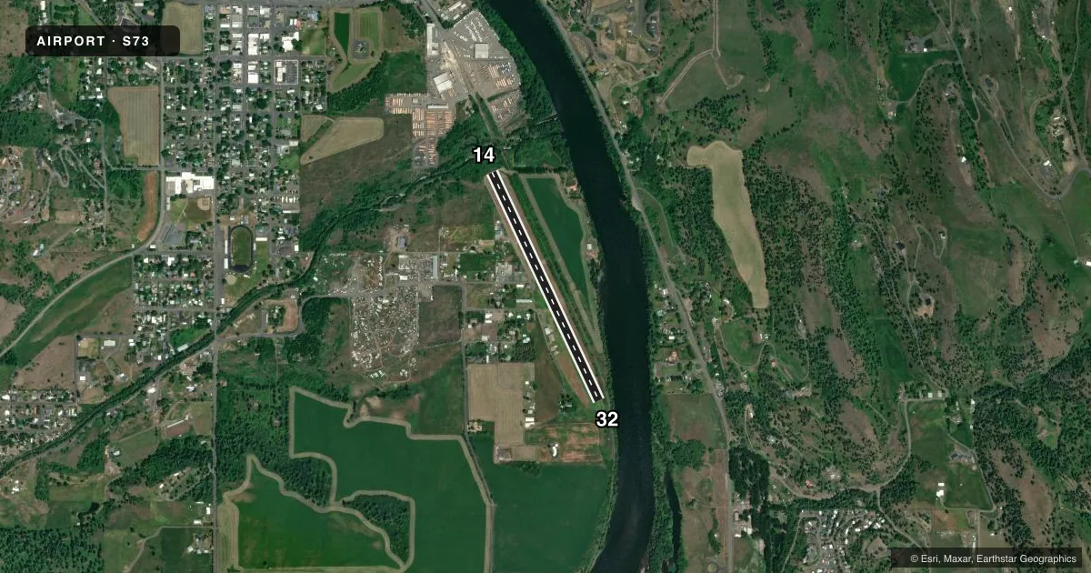
Runways & pattern
Full pagePattern entry · RWY 14
RIGHT TRAFFICRunway end performance
| End | TORA | TODA | ASDA | LDA | VGSI | Approach lights | Obstruction |
|---|---|---|---|---|---|---|---|
| 14 | — | — | — | — | — | — | 50', trees, 300' from thr, 0' R of cntrln, slope 6 |
| 32 | — | — | — | — | — | — | 30', trees, 175' from thr, 100' R of cntrln, slope 5 |
Declared distances in feet. TORA = takeoff run available, TODA = takeoff distance, ASDA = accelerate-stop, LDA = landing distance.
Airport sketch
Runways drawn to scale from FAA survey coordinates, rendered over satellite imagery. Not for navigation.
Approaches & charts
Services on the field
Fuel grades, oxygen, maintenance, ramp storage and lighting — as declared to the FAA by the airport operator.
Fuel & services
- Fuel
- 100LL
- Oxygen (bottled)
- Not available
- Oxygen (bulk)
- Not available
- Other services
- INSTR
Ramp & ground
- Transient storage
- Tie-down
- Landing fee
- No fee published
- Customs
- Not available
- Lighting schedule
- SEE RMK
- Wind indicator
- Lighted
- Segmented circle
- No
Fuel & FBOs
Cheapest 100LL and Jet A on the field and nearby. Always confirm with the FBO before taxi.
Airport notes
Surface conditions, obstructions, local procedures, lighting outages and other notes published with each FAA cycle.
General notes
- FOR RWY CONDS DRG WINT MONTHS CALL AMGR 208-935-0089.
- NUMEROUS OBSTNS ON BOTH RY APCHS; DOWNDRAFTS PREVALENT OVER RIVER ON RY 32 APCH.
- CANADIAN GEESE ON AND INVOF ARPT. DEER MAY BE PRSNT ON RWY AT NGT.
- NOT RCMD TSNT PILOTS LAND AFT DARK WO FIRST BCMG FAM WITH ARPT DUE TO HI TRRN .5 MI FM RWY.
- FOR CD CTC SEATTLE ARTCC AT 253-351-3694.
Lighting notes
- ACTIVATE LIRL RY 14/32 - CTAF.
Runway surface & condition
- 14/32NSTD LIRL BGN 500 FT FM EACH APCH END - 500 FT UNLGTD DTHR AT BOTH RWY ENDS.
Approach & departure obstructions
- 32YELLOW/BLACK PANEL MARKERS ON RWY 32 THR FENCE.
Other notes
- ESTABD PRIOR TO 5/15/59.
- MANAGERALT NMBR: NICK GRACHANIN (MGR) - 208-935-8061 OR GEORGE HUNT 208-935-2940.
VFR map & nearby airports
VFR sectional. Tap any ICAO chip to open that airport.
Key facts · S73
Answer card- ICAO
- S73
- Name
- KAMIAH MUNI
- Location
- KAMIAH, IDAHO
- Elevation
- 1,206 ft MSL
- Traffic pattern altitude
- 2,206 ft MSL (1,000 AGL)
- Control tower
- Non-towered (use CTAF)
- Total runways
- 1
- Longest runway
- 14/32 · 3,000 ft
- Published ILS approaches
- 0
- Published frequencies
- 1
- Magnetic variation
- 18°
- Current flight rules
- VFR
- Current wind
- 000° at 0 kt
- Favored runway now
- –
Kamiah Muni is in Kamiah, Idaho. The field elevation is 1,206 ft MSL. It has one runway, 14/32, which is 3,000 ft of turf. There is no control tower. CTAF is 122.9. No ILS approaches are published. The pattern altitude is not published, so use the standard 1,000 ft AGL for light piston operations unless the current Chart Supplement says otherwise.
Clearwater Valley Aero Club is on the field. It carries 100LL. Call (208) 926-4829 for current fuel or service status. Published remarks matter here. Low intensity runway lights on 14/32 are activated by radio on the CTAF. The first 500 ft from each runway end is unlighted. The runway 32 approach has yellow and black panel markers at the threshold fence. Winter runway conditions should be checked with the airport manager before you go. The Chart Supplement also warns about high terrain close in. It notes numerous obstructions on both approaches. It also mentions downdrafts over the river on the runway 32 side. Deer may be on the runway at night. Canadian geese are also reported on and near the airport. This is not a field to rush into after dark without local familiarity.