METAR & TAF 61S
61S does not publish a METAR.
Showing the nearest reporting station: KEUG (MAHLON SWEET FLD) · 20.8 NM away. Conditions at 61S may differ.
METAR · KEUG
Observed 09:54Z
KEUG 120954Z AUTO 06004KT 10SM CLR 08/07 A3008 RMK AO2 SLP186 T00780067 $
- Wind
- 060° @ 4 kt
- Visibility
- 10 SM
- Temp / Dew
- 8°C / 7°C
- Altimeter
- 30.08 inHg
- Clouds
- CLR
- Density alt
- -239 ft
- Ceiling
- Unlimited
- Rules
- VFR
Airport info & contacts
Manager on record, flight service, ARTCC, attendance schedule and pattern altitude — published by the FAA and refreshed every 28 days.
Location
- From city
- 1 NM E
- VFR sectional
- KLAMATH FALLS
- ARTCC
- ZSE · SEATTLE
- NOTAM facility
- MMV (NOTAM-D)
Airport manager
- Name
- ANTHONY BEACH
- Phone
- 503-378-4880
- Address
- 3040 25TH ST SE, SALEM OR 97302-1125
Flight service · Hours
- FSS MMV
- MC MINNVILLE1-800-WX-BRIEF
- Attendance
- MON-SAT · 1000-1900
Frequencies
Tap any row to copy the frequency to your clipboard.
Runways & pattern
Full pagePattern entry · RWY 33
RIGHT TRAFFICRunway end performance
| End | TORA | TODA | ASDA | LDA | VGSI | Approach lights | Obstruction |
|---|---|---|---|---|---|---|---|
| 15 | — | — | — | — | PAPI 4-box left(3°) | — | 56', trees, 881' from thr, 125' R of cntrln, slope 12 |
| 33 | — | — | — | — | PAPI 4-box right(4.2°) | — | 52', trees, 894' from thr, 100' R of cntrln, slope 13 |
Declared distances in feet. TORA = takeoff run available, TODA = takeoff distance, ASDA = accelerate-stop, LDA = landing distance.
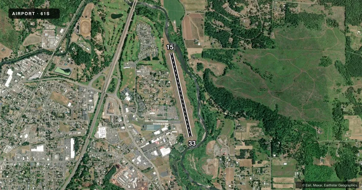
Airport sketch
Runways drawn to scale from FAA survey coordinates, rendered over satellite imagery. Not for navigation.
Approaches & charts
Services on the field
Fuel grades, oxygen, maintenance, ramp storage and lighting — as declared to the FAA by the airport operator.
Fuel & services
- Fuel
- 100LL
- Oxygen (bottled)
- Not available
- Oxygen (bulk)
- Not available
- Airframe repair
- Minor
- Power plant repair
- Minor
Ramp & ground
- Transient storage
- Tie-down
- Landing fee
- No fee published
- Customs
- Not available
- Lighting schedule
- SEE RMK
- Beacon schedule
- SS-SR
- Beacon
- White / Green (civil land)(WG)
- Wind indicator
- Lighted
- Segmented circle
- Yes
Fuel & FBOs
Cheapest 100LL and Jet A on the field and nearby. Always confirm with the FBO before taxi.
Airport notes
Surface conditions, obstructions, local procedures, lighting outages and other notes published with each FAA cycle.
General notes
- HIGH CONCENTRATION OF BIRDS ON & INVOF ARPT.
- DEER ON & INVOF ARPT ALL HRS.
- TWYS 25 FT WIDE, MKD WITH BLUE REFLECTORS.
- FOR CD CTC CASCADE APCH AT 541-607-4674/4675, WHEN APCH CLSD CTC SEATTLE ARTCC AT 253-351-3694.
Lighting notes
- ACTVT MIRL RY 15/33, PAPI RY 15 & RY 33 - CTAF.
Fuel notes
- 100LLFUEL AVBL 24 HR SELF SERVE CARDLOCK.
Other notes
- UNICOM MNTD M-F 0700-1800 LST
VFR map & nearby airports
VFR sectional. Tap any ICAO chip to open that airport.
Key facts · 61S
Answer card- ICAO
- 61S
- Name
- COTTAGE GROVE STATE
- Location
- COTTAGE GROVE, OREGON
- Elevation
- 644.7 ft MSL
- Traffic pattern altitude
- 1,644.7 ft MSL (1,000 AGL)
- Control tower
- Non-towered (use CTAF)
- Total runways
- 1
- Longest runway
- 15/33 · 3,201 ft
- Published ILS approaches
- 0
- Published frequencies
- 2
- Magnetic variation
- 19°
- Current flight rules
- VFR
- Current wind
- 060° at 4 kt
- Favored runway now
- RWY 33
Cottage Grove State Airport sits in Cottage Grove, Oregon. Field elevation is 644.7 ft MSL. The airport has one runway. Runway 15/33 is 3,201 ft long. There is no control tower. UNICOM is monitored Monday through Friday from 0700 to 1800 local standard time. CTAF is 122.8.
No ILS approaches are published here. Pattern altitude is not published, so use the standard 1,000 ft AGL for light piston traffic unless the current FAA Chart Supplement says otherwise. The field has medium intensity runway lights on 15/33. PAPI is installed for both runway ends. Taxiways are 25 feet wide and marked with blue reflectors.
Cottage Grove State Airport has one on-field FBO. Cottage Grove State Airport carries AVGAS 100LL. Fuel is available 24 hours via self-serve cardlock. For clearance delivery, contact Cascade Approach. When approach is closed, contact Seattle ARTCC. First-time pilots should watch for deer and birds on and near the airport at all hours. That matters here more than most places. If you are planning a night arrival or a low-visibility departure, verify current procedures with the airport operator or the FBO directly by phone before you go.