METAR & TAF KYKM
Current METAR
Observed 16:53Z
KYKM 271653Z 00000KT 10SM CLR 23/08 A3003 RMK AO2 SLP162 T02330078
- Wind
- 000° @ 0 kt
- Visibility
- 10 SM
- Temp / Dew
- 23°C / 8°C
- Altimeter
- 30.03 inHg
- Clouds
- CLR
- Density alt
- 2,186 ft
- Ceiling
- Unlimited
- Rules
- VFR
Airport info & contacts
Manager on record, flight service, ARTCC, attendance schedule and pattern altitude — published by the FAA and refreshed every 28 days.
Location
- From city
- 3 NM S
- VFR sectional
- SEATTLE
- ARTCC
- ZSE · SEATTLE
- NOTAM facility
- YKM (NOTAM-D)
Airport manager
- Name
- CHRISTOPHER HOPKINS
- Phone
- 509-575-6149
- Address
- 2406 WEST WASHINGTON AVE, SUITE B, YAKIMA WA 98903
Flight service · Hours
- FSS SEA
- SEATTLE1-800-WX-BRIEF
- Attendance
- 0600 - 2000
Frequencies
Tap any row to copy the frequency to your clipboard.
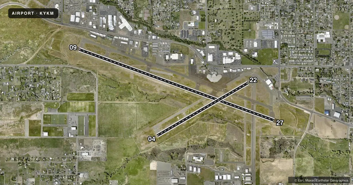
Runways & pattern
Full pagePattern entry · RWY 09
LEFT TRAFFIC| Runway | Heading (°M) | Length | Surface | Traffic |
|---|---|---|---|---|
| 09/27 | 94° / 274° | 7,604 ft | ASPH | Standard L |
| 04/22 | 44° / 224° | 3,835 ft | ASPH | Standard L |
Runway end performance
| End | TORA | TODA | ASDA | LDA | VGSI | Approach lights | Obstruction |
|---|---|---|---|---|---|---|---|
| 09 | 7,604' | 7,604' | 7,604' | 7,604' | VASI 4-box left(3°) | — | — |
| 27 | 7,604' | 7,604' | 7,604' | 7,604' | PAPI 4-box left(3°) | MALSR | — |
| 04 | 3,835' | 3,835' | 3,835' | 3,835' | PAPI 4-box left(3°) | — | — |
| 22 | 3,835' | 3,835' | 3,835' | 3,835' | PAPI 4-box left(3°) | — | — |
Declared distances in feet. TORA = takeoff run available, TODA = takeoff distance, ASDA = accelerate-stop, LDA = landing distance.
Airport sketch
Runways drawn to scale from FAA survey coordinates, rendered over satellite imagery. Not for navigation.
Approaches & charts
ILS · 1
Services on the field
Fuel grades, oxygen, maintenance, ramp storage and lighting — as declared to the FAA by the airport operator.
Fuel & services
- Fuel
- 100LLA
- Oxygen (bottled)
- High pressure
- Oxygen (bulk)
- High pressure
- Airframe repair
- Major
- Power plant repair
- Major
- Other services
- AFRT,AMB,AVNCS,CHTR,INSTR,RNTL,SALES
Ramp & ground
- Transient storage
- Tie-down
- Landing fee
- No fee published
- Lighting schedule
- SEE RMK
- Beacon schedule
- SS-SR
- Beacon
- White / Green (civil land)(WG)
- Wind indicator
- Lighted
- Segmented circle
- Yes
Fuel & FBOs
Cheapest 100LL and Jet A on the field and nearby. Always confirm with the FBO before taxi.
Airport notes
Surface conditions, obstructions, local procedures, lighting outages and other notes published with each FAA cycle.
General notes
- BE ALERT: BIRDS IN VICINTY OF YAKIMA RIVER 5 NM E OF APCH TO 27.
- TWY B FM APCH END OF RY 22 TO TWY A RESTRICTED TO ACFT WITH WINGSPANS OF 79 FT OR LESS.
- RWY 4/22 MIRL, REILS AND PAPIS OTS WHEN TWR CLOSED.
- TWY B1 AND TWY B2 TWY LIGHTS OTS WHEN TWR CLOSED.
- TWY B LIGHTS SOUTH OF RWY 9/27 OTS WHEN TWR CLOSED.
- REFLECTORS ON TWY C ONLY.
- MAIN TERMINAL RAMP RESTRICTED TO AIR CARRIER AIRCRAFT ONLY. RESTRICTED AREA OUTLINED WITH RED MARKINGS.
- FOR CD IF UNA TO CTC ON FSS FREQ, CTC SEATTLE ARTCC AT 253-351-3694.
- SURF CONDS UNMON 2400-0500L
Lighting notes
- WHEN ATCT CLSD ACTVT HIRL RY 09/27; MALSR RY 27 - CTAF.
Runway surface & condition
- 04/22PCR VALUE: 282/F/D/X/T
- 09/27PCR VALUE: 814/F/C/X/T
Other notes
- ESTABD PRIOR TO 15 MAY 1959.
- PPR FOR UNSKED ACR OPNS WITH MORE THAN 30 PSGR SEATS CALL AMGR 509-575-6149/6150.
- 04/22RY 04/22 SOME SPALLING AND RAVELING.
VFR map & nearby airports
VFR sectional. Tap any ICAO chip to open that airport.
Key facts · KYKM
Answer card- ICAO
- KYKM
- Name
- YAKIMA AIR TRML/MCALLISTER FLD
- Location
- YAKIMA, WASHINGTON
- Elevation
- 1,098.8 ft MSL
- Traffic pattern altitude
- 2,098.8 ft MSL (1,000 AGL)
- Control tower
- Towered · 0600-2200
- Total runways
- 2
- Longest runway
- 09/27 · 7,604 ft
- Published ILS approaches
- 1
- Published frequencies
- 11
- Magnetic variation
- 16°
- Current flight rules
- VFR
- Current wind
- 000° at 0 kt
- Favored runway now
- –
Yakima Air Trml/McAllister Fld sits in Yakima, Washington at 1,098.8 ft MSL. It has two asphalt runways. The longest is 09/27 at 7,604 ft. Runway 04/22 is 3,835 ft. The field is towered from 0600 to 2200 local. One ILS is published for runway 27. Pattern altitude is not published in the facts, so verify the current Chart Supplement before you go.
McCormick Air Center is on the field. It carries 100LL, Jet A and Jet A Prist. McAllister Museum of Aviation is also on the field. It carries 100LL. For a first-time arrival, pay attention to the terminal ramp restriction. The main terminal ramp is for air carrier aircraft only. Surface conditions are not monitored from 2400 to 0500 local. Bird activity is called out near the Yakima River about 5 NM east of the runway 27 approach. When the tower is closed, runway 09/27 lighting can be activated on CTAF. Some runway 04/22 lighting items are out of service when the tower is closed. Taxiway B lights south of runway 9/27 are also out of service when the tower is closed. Check the current Chart Supplement for any noise or curfew restrictions before flying into the field.