METAR & TAF KWAY
KWAY does not publish a METAR.
Showing the nearest reporting station: KAFJ (WASHINGTON COUNTY) · 15.9 NM away. Conditions at KWAY may differ.
METAR · KAFJ
Observed 08:56Z
KAFJ 120856Z AUTO 22007KT 10SM FEW095 23/22 A2987 RMK AO2 SLP105 T02330217 56019 $
- Wind
- 220° @ 7 kt
- Visibility
- 10 SM
- Temp / Dew
- 23°C / 22°C
- Altimeter
- 29.87 inHg
- Clouds
- FEW
- Density alt
- 2,347 ft
- Ceiling
- Unlimited
- Rules
- VFR
Airport info & contacts
Manager on record, flight service, ARTCC, attendance schedule and pattern altitude — published by the FAA and refreshed every 28 days.
Location
- From city
- 2 NM E
- VFR sectional
- CINCINNATI
- ARTCC
- ZOB · CLEVELAND
- NOTAM facility
- AOO (NOTAM-D)
Airport manager
- Name
- MARIO BARCHIESI
- Phone
- 724-998-5042
- Address
- 107 FAIRGROUNDS RD, WAYNESBURG PA 15370
Flight service · Hours
- FSS AOO
- ALTOONA1-800-WX-BRIEF
- Attendance
- Unattended
Frequencies
Tap any row to copy the frequency to your clipboard.
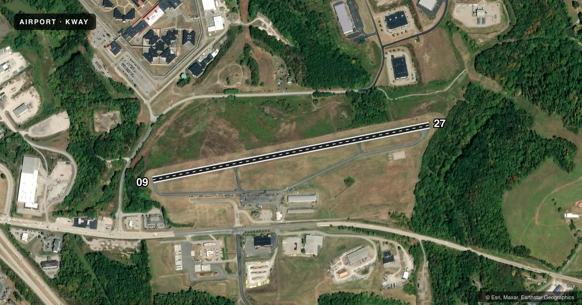
Runways & pattern
Full pagePattern entry · RWY 27
LEFT TRAFFICRunway end performance
| End | TORA | TODA | ASDA | LDA | VGSI | Approach lights | Obstruction |
|---|---|---|---|---|---|---|---|
| 09 | — | — | — | — | — | — | 17', trees, 257' from thr, 116' R of cntrln, slope 3 |
| 27 | — | — | — | — | — | — | 28', trees, 285' from thr, 84' R of cntrln, slope 3 |
Declared distances in feet. TORA = takeoff run available, TODA = takeoff distance, ASDA = accelerate-stop, LDA = landing distance.
Airport sketch
Runways drawn to scale from FAA survey coordinates, rendered over satellite imagery. Not for navigation.
Approaches & charts
Services on the field
Fuel grades, oxygen, maintenance, ramp storage and lighting — as declared to the FAA by the airport operator.
Fuel & services
- Fuel
- 100LL
- Oxygen (bottled)
- Not available
- Airframe repair
- Major
- Power plant repair
- Major
- Other services
- GLD
Ramp & ground
- Transient storage
- Tie-down
- Hangar
- Landing fee
- No fee published
- Customs
- Not available
- Wind indicator
- Yes
- Segmented circle
- Yes
Fuel & FBOs
Cheapest 100LL and Jet A on the field and nearby. Always confirm with the FBO before taxi.
Airport notes
Surface conditions, obstructions, local procedures, lighting outages and other notes published with each FAA cycle.
General notes
- GROUND DROPS OFF SHARPLY EAST END RY 09/27.
- DEER AND BIRDS ON & INVOF RY.
- 290 FT HIGH TERRAIN 1,900 FT SOUTH OF RY.
- FOR CD CTC CLARKSBURG APCH AT 304-842-2011, WHEN APCH CLSD CTC CLEVELAND ARTCC AT 440-774-0226.
- EXTSV GLIDER OPS WKENDS.
- DALGT OPNS ONLY.
Approach & departure obstructions
- 0915 FT TREES, 128 FT FM RWY END, 166 FT R; 19 FT TREES, 95 FT FM RWY END 180 FT L.
- 09RWY NRS AND CL MRKGS IN POOR COND.
- 27RWY NRS AND CL MRKGS IN POOR COND.
- 09RY 09 TWO 10 FT BY 120 FT CONCRETE PATCHES LCTD APPRXLY 570 FT DOWN THE RY ON EACH SIDE OF THE CNTRLN.
Other notes
- ESTAB PRIOR TO 1959.
- 4FOR SVC AFT HOURS CTC 724-993-2190.
VFR map & nearby airports
VFR sectional. Tap any ICAO chip to open that airport.
Key facts · KWAY
Answer card- ICAO
- KWAY
- Name
- GREENE COUNTY
- Location
- WAYNESBURG, PENNSYLVANIA
- Elevation
- 1,068.6 ft MSL
- Traffic pattern altitude
- 2,068.6 ft MSL (1,000 AGL)
- Control tower
- Non-towered (use CTAF)
- Total runways
- 1
- Longest runway
- 09/27 · 3,500 ft
- Published ILS approaches
- 0
- Published frequencies
- 4
- Magnetic variation
- 9°
- Current flight rules
- VFR
- Current wind
- 220° at 7 kt
- Favored runway now
- RWY 27
Greene County Airport sits in Waynesburg, Pennsylvania. The field elevation is 1,068.6 ft MSL. It has one runway, 09/27, which is 3,500 ft long and asphalt. There is no control tower. Approach services are listed through Clarksburg. CTAF and UNICOM are both on 122.8. No ILS approaches are published. The pattern altitude is not published, so a light piston pilot should plan on the standard 1,000 ft AGL unless the current FAA Chart Supplement says otherwise.
Greene County Airport has one on-field FBO, Greene County Airport. It carries 100LL. For after-hours service, the published remarks give a phone number to call. The remarks also note daylight operations only. That matters here. The field also has extensive glider activity on weekends. Expect mixed traffic and stay sharp on the radio.
There are a few runway items to know before you go. The east end drops off sharply. There is high terrain south of the field. Runway numbers and centerline markings are in poor condition on both ends. Deer and birds are also reported on and near the runway. If you are planning a first trip in, get the current FAA Chart Supplement and brief the runway condition, terrain and daylight-only note before departure.