METAR & TAF KTYS
Current METAR
Observed 15:53Z
KTYS 271553Z 02003KT 10SM FEW013 BKN040 OVC200 27/22 A2996 RMK AO2 SLP132 T02670217
- Wind
- 020° @ 3 kt
- Visibility
- 10 SM
- Temp / Dew
- 27°C / 22°C
- Altimeter
- 29.96 inHg
- Clouds
- OVC
- Density alt
- 2,614 ft
- Ceiling
- 4,000 ft AGL
- Rules
- VFR
Airport info & contacts
Manager on record, flight service, ARTCC, attendance schedule and pattern altitude — published by the FAA and refreshed every 28 days.
Location
- From city
- 10 NM S
- VFR sectional
- ATLANTA
- ARTCC
- ZTL · ATLANTA
- NOTAM facility
- TYS (NOTAM-D)
Airport manager
- Name
- PATRICK WILSON
- Phone
- 865-342-3088
- Address
- P.O. BOX 15600, KNOXVILLE TN 37901
Flight service · Hours
- FSS BNA
- NASHVILLE1-800-WX-BRIEF
- Attendance
- ALL
Frequencies
Tap any row to copy the frequency to your clipboard.
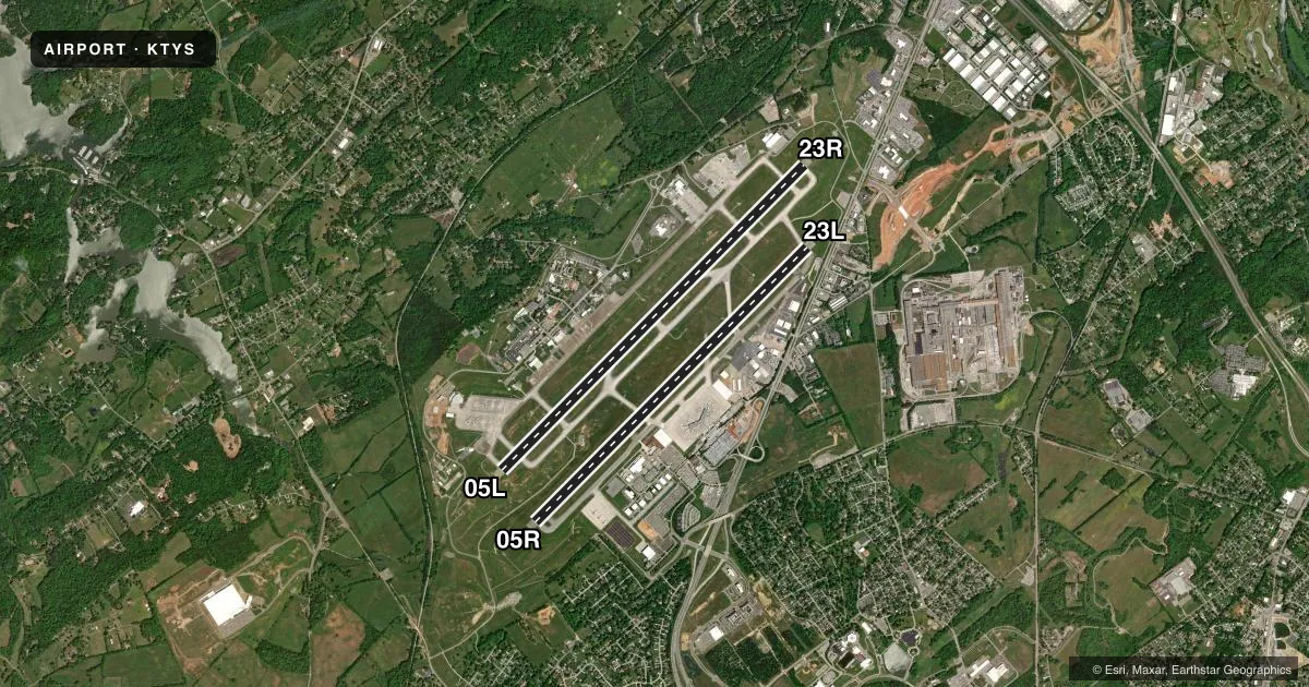
Runways & pattern
Full pagePattern entry · RWY 05L
LEFT TRAFFIC| Runway | Heading (°M) | Length | Surface | Traffic |
|---|---|---|---|---|
| 05L/23RFavored | 39° / 219° | 10,000 ft | CONC | 23R R |
| 05R/23L | 39° / 219° | 9,000 ft | ASPH | 05R R |
Runway end performance
| End | TORA | TODA | ASDA | LDA | VGSI | Approach lights | Obstruction |
|---|---|---|---|---|---|---|---|
| 05L | 10,000' | 10,000' | 10,000' | 9,508' | PAPI 4-box left(3°) | MALSR | — |
| 23R | 10,000' | 10,000' | 10,000' | 9,495' | PAPI 4-box left(3°) | ALSF2 | — |
| 05R | 9,000' | 9,000' | 8,600' | 8,600' | PAPI 4-box left(3°) | — | — |
| 23L | 9,000' | 9,000' | 9,000' | 8,600' | PAPI 4-box left(3°) | — | — |
Declared distances in feet. TORA = takeoff run available, TODA = takeoff distance, ASDA = accelerate-stop, LDA = landing distance.
Airport sketch
Runways drawn to scale from FAA survey coordinates, rendered over satellite imagery. Not for navigation.
Approaches & charts
ILS · 3
Services on the field
Fuel grades, oxygen, maintenance, ramp storage and lighting — as declared to the FAA by the airport operator.
Fuel & services
- Fuel
- 100LLAA++
- Oxygen (bulk)
- High pressure
- Airframe repair
- Major
- Power plant repair
- Major
- Other services
- AFRT,AVNCS,CARGO,CHTR,INSTR,RNTL,SALES,SURV
Ramp & ground
- Transient storage
- Tie-down
- Hangar
- Landing fee
- No fee published
- Customs
- Not available
- Lighting schedule
- SS-SR
- Beacon schedule
- SS-SR
- Beacon
- White / Green (civil land)(WG)
- Wind indicator
- Lighted
- Segmented circle
- Yes
Fuel & FBOs
Cheapest 100LL and Jet A on the field and nearby. Always confirm with the FBO before taxi.
Airport notes
Surface conditions, obstructions, local procedures, lighting outages and other notes published with each FAA cycle.
General notes
- BIRDS ON & INVOF OF ARPT; INCRD OCT-APR.
- CIVIL PPR TO USE TWYS G1, G2, G3 & G SOUTH OF TWY G4 - ANG 865-336-4371.
- RWY 23L & 23R DEP MNTN RWY HDG UNTIL PASSING RESIDENTIAL AREA S OF EXTDD CNTRLN UNLESS INSTRD BY ATC.
- WIDE BODY USE CTN TURNING ONTO TWY A FM RAMP 4, 5 & 6.
- CTN: PTN OF TWY A NEAR RWY 05R APCH END NOT VSB FM TWR.
- ANG OPS CTC SODA CTL 303.025.
- ANG: COMD POST H24 - D266-4371/ C865-336-4371. AMGR DOES NOT ISSUE OR STORE COMSEC FOR TSNT. TMPRY STOR OF CLASSIFIED MATERIALS UP TO TOP SECRET AT COMD POST.
- ANG: PPR 24 HR PN RQR, LTD TO OFFL BUS ONLY, CTC AIRFIELD MGMT DSN 266-4404/4419, C865-336-4404/4419. OPR 0700-1630 MON-FRI (CLSD EV OTH MON), FAC CLSD SAT, SUN AND HOL.
- CTN: HOLD SHORT LINE FOR RWY 23L SLIGHTLY N OF TWY A-8.
- ANG: ARNG RAMP NOT SUITABLE FOR AMC ACFT EXC C-21.
- CSTMS/AG/IMG: MIL CUSTOMS 72 HR PPR.
- RWY 5L/23R & 5R/23L WT BRG CPTY FOR 2S LNDG GEAR IS 175.
- ACFT DESIGN GROUP V OR LRGR USING TRML RAMP RQR PPR 865-342-3177.
- GA RAMP NOT AVBL FOR ACR OPS.
- ARNG: BASEOPS OPR 0700-1630 MON-FRI (CLSD EV OTH MON), FAC CLSD SAT, SUN AND HOL. C629-332-8765/8809, DSN 312-683-8765/8809.
- RWY 05R/23L DIST RMNG SIGNS ARE REMOVED.
Fuel notes
- 100LLMIL CONTR FUEL AVBL.
Runway surface & condition
- 05L/23RPCR VALUE: 761/R/B/W/T
- 05R/23LPCR VALUE: 492/F/B/X/U
VFR map & nearby airports
VFR sectional. Tap any ICAO chip to open that airport.
Key facts · KTYS
Answer card- ICAO
- KTYS
- Name
- MC GHEE TYSON
- Location
- KNOXVILLE, TENNESSEE
- Elevation
- 986.4 ft MSL
- Traffic pattern altitude
- 1,986.4 ft MSL (1,000 AGL)
- Control tower
- Towered · 24
- Total runways
- 2
- Longest runway
- 05L/23R · 10,000 ft
- Published ILS approaches
- 3
- Published frequencies
- 18
- Magnetic variation
- 6°
- Current flight rules
- VFR
- Current wind
- 020° at 3 kt
- Favored runway now
- RWY 05L
Mc Ghee Tyson Airport sits in Knoxville, Tennessee. Field elevation is 986.4 ft MSL. The airport has two runways. The longest is runway 05L/23R at 10,000 ft. Runway 05R/23L is 9,000 ft. The control tower is open 24 hours.
ILS service is available on three runway ends. Those are 05L, 23L and 23R. Pattern altitude is not published in the facts. Use the standard 1,000 ft AGL pattern unless ATC gives you something different. That works out to about 1,986 ft MSL at this field.
Signature Aviation is on the field. It carries 100LL, Jet A and Jet A Prist. Call (865) 970-9000 for current ramp and service details. Published remarks also note bird activity on and near the airport. Expect more of that from October through April. There is also a note that runway 23L departures should hold runway heading until past the residential area south of the extended centerline unless ATC says otherwise.
This is a busy Class C field. Check current ATC instructions before arrival. The field also has ANG prior permission requirements for some use. It also has restricted access to certain taxiways. If you are planning a first visit, verify the current Chart Supplement and coordinate with the airport operator or FBO before you launch.