METAR & TAF KTUL
Current METAR
Observed 16:53Z
KTUL 121653Z 07006KT 10SM BKN018 BKN030 27/22 A3002 RMK AO2 SLP156 T02670217
- Wind
- 070° @ 6 kt
- Visibility
- 10 SM
- Temp / Dew
- 27°C / 22°C
- Altimeter
- 30.02 inHg
- Clouds
- BKN
- Density alt
- 2,156 ft
- Ceiling
- 1,800 ft AGL
- Rules
- MVFR
Airport info & contacts
Manager on record, flight service, ARTCC, attendance schedule and pattern altitude — published by the FAA and refreshed every 28 days.
Location
- From city
- 5 NM NE
- VFR sectional
- KANSAS CITY
- ARTCC
- ZKC · KANSAS CITY
- NOTAM facility
- TUL (NOTAM-D)
Airport manager
- Name
- ALEXIS HIGGINS
- Phone
- 918-838-5000
- Address
- PO BOX 581838, TULSA OK 74158
Flight service · Hours
- FSS MLC
- MC ALESTER1-800-WX-BRIEF
- Attendance
- ALL
Frequencies
Tap any row to copy the frequency to your clipboard.
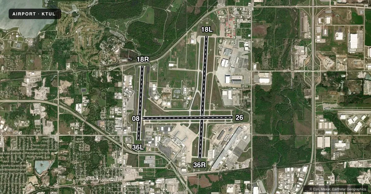
Runways & pattern
Full pagePattern entry · RWY 08
LEFT TRAFFIC| Runway | Heading (°M) | Length | Surface | Traffic |
|---|---|---|---|---|
| 18L/36R | 180° / 0° | 10,000 ft | CONC | 36R R |
| 08/26Favored | 86° / 266° | 7,376 ft | CONC | Standard L |
| 18R/36L | 180° / 0° | 6,101 ft | ASPH | 18R R |
Runway end performance
| End | TORA | TODA | ASDA | LDA | VGSI | Approach lights | Obstruction |
|---|---|---|---|---|---|---|---|
| 18L | 10,000' | 10,000' | 10,000' | 10,000' | PAPI 4-box left(2.75°) | MALSR | 41', tree, 1894' from thr, 471' R of cntrln, slope 41 |
| 36R | 10,000' | 10,000' | 10,000' | 10,000' | PAPI 4-box left(3°) | ALSF2 | 29', tree, 1593' from thr, 127' R of cntrln, slope 48 |
| 08 | 7,376' | 7,376' | 7,376' | 7,376' | PAPI 4-box left(3°) | — | 36', tree, 1775' from thr, 430' R of cntrln, slope 43 |
| 26 | 7,376' | 7,376' | 7,376' | 7,376' | PAPI 4-box left(3°) | MALSR | — |
| 18R | 6,101' | 6,101' | 5,741' | 5,141' | PAPI 4-box left(2.75°) | — | — |
| 36L | 6,101' | 6,101' | 5,101' | 5,101' | PAPI 4-box left(3°) | — | 10', road, 200' from thr, 419' R of cntrln, slope 1 |
Declared distances in feet. TORA = takeoff run available, TODA = takeoff distance, ASDA = accelerate-stop, LDA = landing distance.
Airport sketch
Runways drawn to scale from FAA survey coordinates, rendered over satellite imagery. Not for navigation.
Approaches & charts
ILS · 3
Services on the field
Fuel grades, oxygen, maintenance, ramp storage and lighting — as declared to the FAA by the airport operator.
Fuel & services
- Fuel
- 100LLA
- Oxygen (bottled)
- HIGH/LOW
- Oxygen (bulk)
- HIGH/LOW
- Airframe repair
- Major
- Power plant repair
- Major
- Other services
- AFRT,AMB,AVNCS,CARGO,CHTR,INSTR,RNTL,SALES
Ramp & ground
- Transient storage
- Tie-down
- Hangar
- Landing fee
- No fee published
- Customs
- Not available
- Lighting schedule
- SS-SR
- Beacon schedule
- SS-SR
- Beacon
- White / Green (civil land)(WG)
- Wind indicator
- Lighted
- Segmented circle
- No
Fuel & FBOs
Cheapest 100LL and Jet A on the field and nearby. Always confirm with the FBO before taxi.
Airport notes
Surface conditions, obstructions, local procedures, lighting outages and other notes published with each FAA cycle.
General notes
- CTN: 4000 FT BLACKTOP TRACK 1.5 NM E RWY 26; DO NOT MISTAKE FOR RWY.
- WT RSTRD AREAS: TWY JJ S-35; TWY M2 S-81/D-140/DT-186; TWY HH S-55/D-60; TWY L NORTH OF RWY 08/26 S-93/D-140/DT 209; TWY L BTN TWY C & TWY L2 S-120/D-250/DT 372; TWY L2 S-70/D-100/DT-166.
- NOISE ABATEMENT ALL RWYS: CLIMB TO 3000 FT ASAP AFT TKOF.
- TXLS LA, LB, NN & QQ NOT VSB FM ATCT.
- BIRDS ON & INVOF ARPT.
- APVD ACFT RUN UP AREA: 2300-0600 N END TWY J ACFT ORIENTATION N & S. 24 HR APCH END RWY 26 ACFT ORIENTATION E & W. 0600-2300 N END TWY L ACFT ORIENTATION N & S.
- TWY L SOUTH OF TWY L3 NOT VSB TO ATCT.
- TXL LB NOT VSB TO ATCT.
Runway surface & condition
- 08/26PCR VALUE: 626/R/B/W/T
- 18L/36RPCR VALUE: 1175/R/C/W/T
- 18R/36LPCR VALUE: 427/F/D/X/T
Approach & departure obstructions
- 18RIREG WIND PAT.
- 08PAPI UNUSBL BYD 8 DEGS LEFT & RIGHT OF RWY CNTRLN.
- 26PAPI UNUSBL BYD 7 DEGS RIGHT & 9 DEGS LEFT OF CNTRLN.
Arresting gear
- 08_BAK-14BAK-14 BAK-12A(B) (1500 FT).
- 18L_BAK-14BAK-14 BAK-12A(B) (1500 FT).
- 26_BAK-14BAK-14 BAK-12A(B) (1500 FT).
- 36R_BAK-14BAK-14 BAK-12A(B) (1500 FT).
VFR map & nearby airports
VFR sectional. Tap any ICAO chip to open that airport.
Key facts · KTUL
Answer card- ICAO
- KTUL
- Name
- TULSA INTL
- Location
- TULSA, OKLAHOMA
- Elevation
- 677.8 ft MSL
- Traffic pattern altitude
- 1,677.8 ft MSL (1,000 AGL)
- Control tower
- Towered · 24
- Total runways
- 3
- Longest runway
- 18L/36R · 10,000 ft
- Published ILS approaches
- 3
- Published frequencies
- 22
- Magnetic variation
- 3°
- Current flight rules
- MVFR
- Current wind
- 070° at 6 kt
- Favored runway now
- RWY 08
Tulsa Intl is in Tulsa, Oklahoma. Field elevation is 677.8 ft MSL. The airport has 3 runways. The longest is 18L/36R at 10,000 ft. Tower service is available 24 hours. Three ILS approaches are published for runway ends 18L, 18R and 36R.
Pattern altitude is not published in the facts. Use the standard 1,000 ft AGL for light piston work unless the current FAA Chart Supplement says otherwise. This is a busy Class C field, so expect a lot of radio traffic and coordinated sequencing. Noise abatement is published for all runways. Climb to 3,000 ft as soon as practical after takeoff.
On the field, Sparks Aviation Center carries 100LL and Jet A Prist. Atlantic Aviation carries 100LL and Jet A. United States Aviation carries Jet A and Jet A Prist. Runway 08 and runway 26 both have arresting systems covering 1,500 ft. Watch the published taxiway weight restrictions. Taxiway L south of taxiway L3 is not visible to the tower. Birds are reported on and near the airport. There is also a 4,000 ft blacktop track 1.5 NM east of runway 26 that should not be mistaken for a runway.